

Winter 2026-27 Outlook: How much snow will Michigan get?
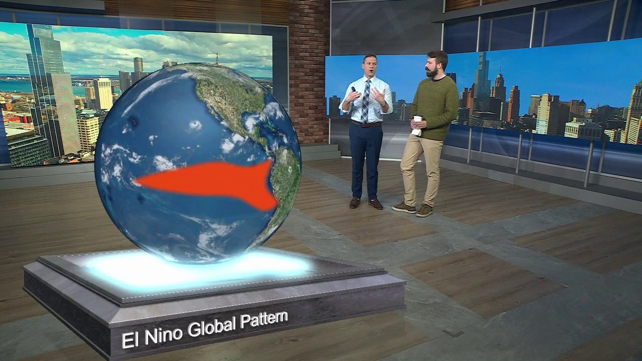
Explaining this year's Super El Niño
What is behind the massive weather event expected to impact the entire globe? FOX 2's Derek Kevra talks the Super El Niño taking aim at the Earth this winter.
(FOX 2) - As winter approaches, the question on everyone's mind is always the same: What kind of winter are we looking at? Will we be spending our weekends shoveling snow, or will the snowblower spend most of the season collecting dust in the garage?
It's a great question, and this year we have a particularly interesting weather pattern developing that could play a major role in what winter looks like across Metro Detroit and Southeast Michigan.
We're heading into what could be one of the strongest El Niño events on record. You may have heard the term "Super El Niño" thrown around recently, and while it sounds dramatic, there's some legitimate science behind it. The last few times we experienced an El Niño of this magnitude, Michigan had some remarkably mild winters with significantly less snow than average.
So, does that mean we're in for another easy winter? Let's look at what history tells us.
What is a Super El Niño?
Looking abroad:
To understand what could happen this winter, we first need to look thousands of miles away from Michigan, toward the equatorial Pacific Ocean — think off the coast of Peru.
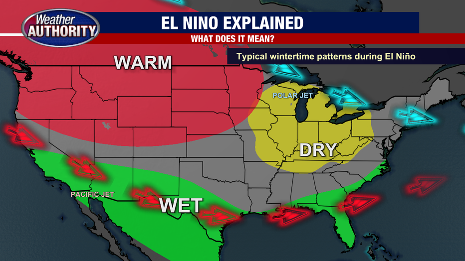
El Niño occurs when ocean temperatures in the central and eastern Pacific become warmer than average. That warmer water influences atmospheric circulation and can alter the position of the jet stream, which plays a major role in steering storms and determining where cold air settles across North America.
During a typical El Niño winter, the northern United States often experiences warmer-than-average temperatures, while a more active southern jet stream brings additional precipitation to portions of the southern United States.
But not all El Niño events are created equal. Some are relatively weak, while others become extremely strong. When Pacific Ocean temperatures climb well above average, we sometimes refer to the event as a Super El Niño.
According to NOAA's October outlook, there is an 83% chance this El Niño reaches historic strength during the October through December period. That means we could be dealing with one of the strongest El Niño events observed since modern records began in 1950.
The last Super El Niño
In history:
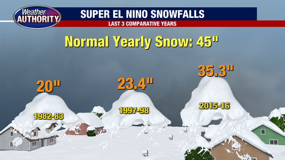
The last Super El Niño occurred during the winter of 2015-2016. Two other particularly strong events occurred during the winters of 1997-1998 and 1982-1983. All three give us an idea of how Michigan's winter weather has responded to similar global patterns in the past.
During the winter of 1982-1983, Detroit received just 20 inches of snow for the entire season. The winter of 1997-1998 wasn't much snowier, with only 23.4 inches. Even the 2015-2016 winter produced below-average snowfall, with approximately 35 inches.
To put that into perspective, Detroit normally receives around 45 inches of snow during an entire season. The two earlier Super El Niño winters produced roughly half of what we would typically expect.
Of course, that doesn't mean every Super El Niño will produce the same result. We only have a handful of comparable events, and there are plenty of other factors that influence our weather. Still, those numbers certainly get our attention.
How will El Niño affect Michigan this winter?
Local perspective:
The biggest influence of a strong El Niño across the Great Lakes is typically a shift toward warmer-than-average temperatures.
That doesn't mean every day will be warm, and it certainly doesn't mean winter disappears. We're still in Michigan, after all, and cold air outbreaks and snowstorms are inevitable. What changes is the overall pattern, with more frequent breaks from the cold and fewer prolonged stretches of bitterly cold weather.
Even a difference of just a few degrees can have a tremendous impact on what kind of precipitation we receive.
Think about a storm system moving through Southeast Michigan with temperatures around 29 or 30 degrees. That could produce several inches of accumulating snow. Raise those temperatures to 35 or 36 degrees, and that same storm could produce mostly rain instead.
That's one of the biggest reasons strong El Niño winters can feature considerably less snowfall, even when storm systems continue moving through the region.
More rain and less snow?
Big picture view:
A warmer winter doesn't necessarily mean we're going to receive more precipitation overall. In fact, El Niño winters can favor somewhat drier conditions across portions of the Great Lakes as the primary storm track shifts farther south.
But the precipitation that does reach us has a better opportunity to fall as rain rather than snow. We could see more winter rain events, mixed precipitation and storms where the rain-snow line sets up somewhere across Southeast Michigan.
There's also the potential for more frequent melting between snow events. Even when we get a decent snowfall, warmer temperatures could make it difficult to maintain a significant snowpack for extended periods.
For those of you who enjoy skiing, snowboarding or snowmobiling, that might not be the news you were hoping to hear. For everyone else who dreads clearing the driveway at 6 a.m., it might sound pretty good.
So, what will this winter be like?
What's next:
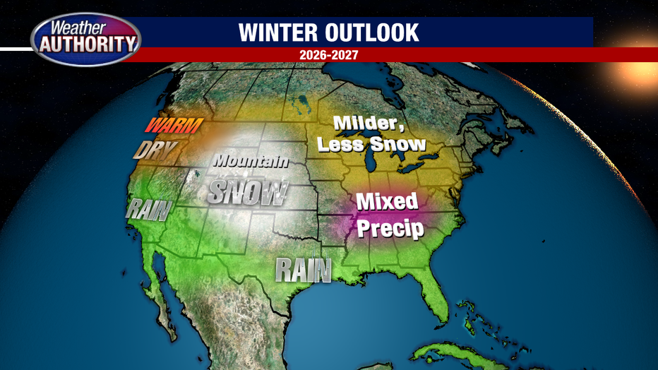
Putting all of this together, I'm leaning toward a warmer-than-average winter across Metro Detroit and Southeast Michigan, with below-average snowfall for the season.
The strength of the developing El Niño, the historical comparisons and NOAA's seasonal temperature outlook all point in that general direction. I also think we'll have more opportunities for winter rain instead of snow, particularly when storm systems bring milder air northward into the Great Lakes.
However, I wouldn't put the snow shovel away just yet. Even the warmest winters can produce significant snowstorms, and one or two well-timed systems can dramatically change our seasonal snowfall totals. And melting snow could refreeze during the overnight hours meaning more icy conditions at times.
We’ll be watching either way!
The Source: FOX 2's meteorology team was cited for this story.