

Metro Detroit Weather: Nasty system of sleet to affect commuters on Wednesday, Thursday

DETROIT (FOX 2) - A freezing weather system is heading into Metro Detroit on Wednesday night into Thursday morning that can affect commuters and make things slick.
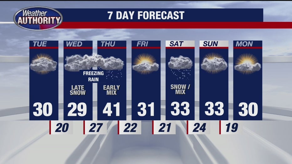
The next weather system will bring a round of sleet and freezing rain to the area.
This may make roads slippery at around midnight on Wednesday.
Timeline:
Around 8 p.m., some snow moves in.
That snow is forecast to transition to freezing rain around midnight and fall until about 7 a.m.
The area is expected to get around 1/10 of an inch of ice, with areas in the southern part of Southeast Michigan possibly receiving a bit more. Though 1/10 doesn't seem like a lot, it is enough to coat roads and create dangerous conditions. The Thursday morning commute is predicted to be slick.
Additionally, that ice will coat power lines, too, creating a chance for power outages.
Forecast:
Here is what the next few days look like:
- Wednesday: Clouds thicken throughout the day, with a late-night wintry mix expected. Low around 26°F.
- Thursday: Early morning wintry mix ending, leading to a milder afternoon. Cloudy with a high near 40°F.
- Friday: Sun and clouds, with a high of 30°F.
- Saturday: Cloudy with some afternoon snow, and some accumulation likely. High around 32°F.
- Sunday: Mostly cloudy, cool, and dry, with a high of 32°F.
- Monday: Partly sunny, with a high of 30°F.
What's next:
Temperature will have an impact on how much impact the ice has.
Keep an eye on weather forecasts to see the latest updates and what to expect as prediction models become clearer.
For the latest forecast, live radar, and more, download the FOX 2 Weather app.