

Future Great Lakes trail to offer unbroken passage along entire shoreline
Plan revealed for a single continuous trail around the Great Lakes
The U.S. Great Lakes Waterfront Trail will one day offer an unbroken path along the entirety of our shorelines that touch the lakes in the U.S. While a good chunk of the proposed path is complete, a lot of work remains.
(FOX 2) - Ferry crossings, international bridges, and thousands of miles of shoreline are all part of what will one day be a continuous trail spanning the entire Great Lakes.
Years of collaboration with the National Parks Service, the Council of State Governments, and coordination with students with the University of Michigan are part of the undertaking that will one day be the U.S. Great Lakes Waterfront Trail.
What exists currently is a patchwork of trails along parts of each state that touch the Great Lakes. But once complete, people moving by bike or by foot will have an unbroken journey awaiting them, from the St. Lawrence River in northern New York all the way up northern Minnesota's shoreline along Lake Superior.
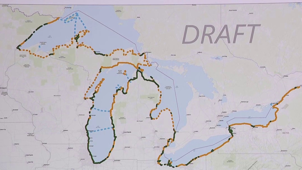
Mapping the Great Lakes Waterfront Trail
Mapping the entire trail has been overseen by the Service Rivers, Trails and Conservation Assistance Program through the National Park.
Canada has a similar version on the other side of the border, which is already mostly complete.
Jess Leinhardt, the Great Lakes Program Director with the Council of State Governments' Midwest Office, said the U.S. network will one day connect with Canada's.
"This is part of a larger project that would connect into Canada's existing Great Lakes Waterfront Trail, which covers their side of the Great Lakes throughout the province of Ontario," she said.
Canada's trail has been in the works for more than 30 years, serving as an inspiration for the U.S. side, said John Hartig, a naturalist and environmental author.
"Canada's version of the Great Lakes Waterfront trail has been around for more than 3 decades, so they are an inspiration to us, and of course then we want to connect to each other," he said.
He estimates the total length of the trail in both countries will span over 6,000 miles — approximately 3,700 on the U.S. side and 2,250 on the Canadian side.

The U.S. Great Lakes Waterfront Trail will eventually link up with a similar network in Canada.
In addition to the Gordie Howe Bridge, international crossings in Messina, New York, Sault Ste. Marie and Port Huron will offer passage over shared river systems, as well as a land crossing in Minnesota near Grand Portage.
It will also make use of already-built networks, including the Iron Belle Trail and the Joe Louis Greenway in Detroit, Hamtramck, and Highland Park.
Dig deeper:
According to the National Park Service's rendering, the green lines designate existing off-road paths for walking and cycling, while the solid yellow lines are for existing designated bike routes for cyclists.
The yellow dotted lines mark potential routes that could be installed in the future, but don't currently exist.
Blue lines designate ferry crossings that allow travelers to bring their bikes.
Creating a roadmap for trail building
Constructing the pathway involves working with every community that finds itself along the network's proposed route.
Graduate students from the University of Michigan crafted a roadmap that can serve as a template for any community interested in linking up with existing parts of the future trail.
Over several months, a team from the School for Environment and Sustainability spent their capstone project coming up with a starter guide to give communities a starting place to help them design a trail.
Using Erie County, Pennsylvania as a test case, they deployed their guide in January 2026 to figure out the best paths through the trail sections in that state.
The full guide can be found here.
The Source: The University of Michigan, the National Parks Service, and Council of State Governments' Midwest Office were cited for this story.