

Hurricane Lee becomes Cat. 3, expected to remain powerful storm through next week: Live updates
Stream FOX 35 News below
Sept. 10 updates below:
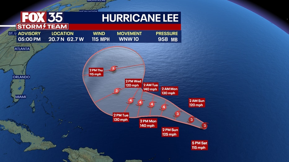
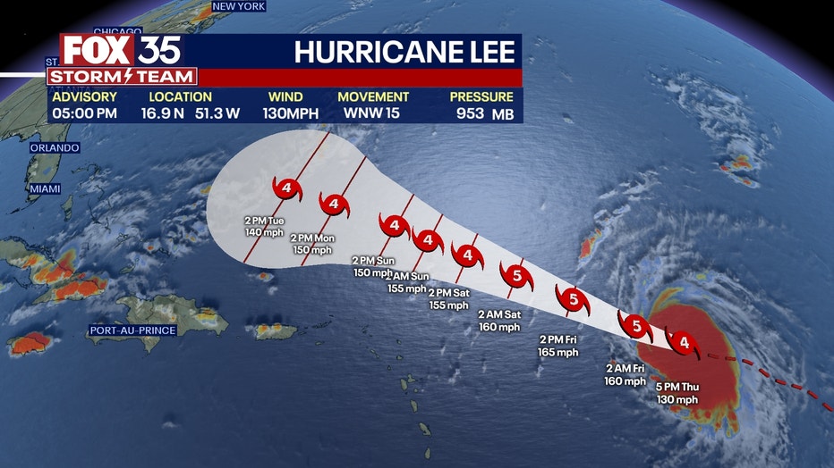
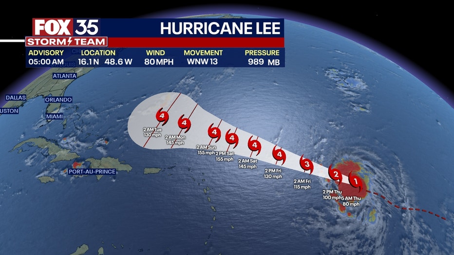
5 p.m. advisory | Hurricane Lee has ramped up again to a Category 3 storm in the Atlantic. Lee is 285 miles north-northeast of the Northern Leeward Islands with sustained winds of 120 mph.
Lee is forecast to strengthen again in the next day or so with fluctuations in intensity possible on Monday and Tuesday.
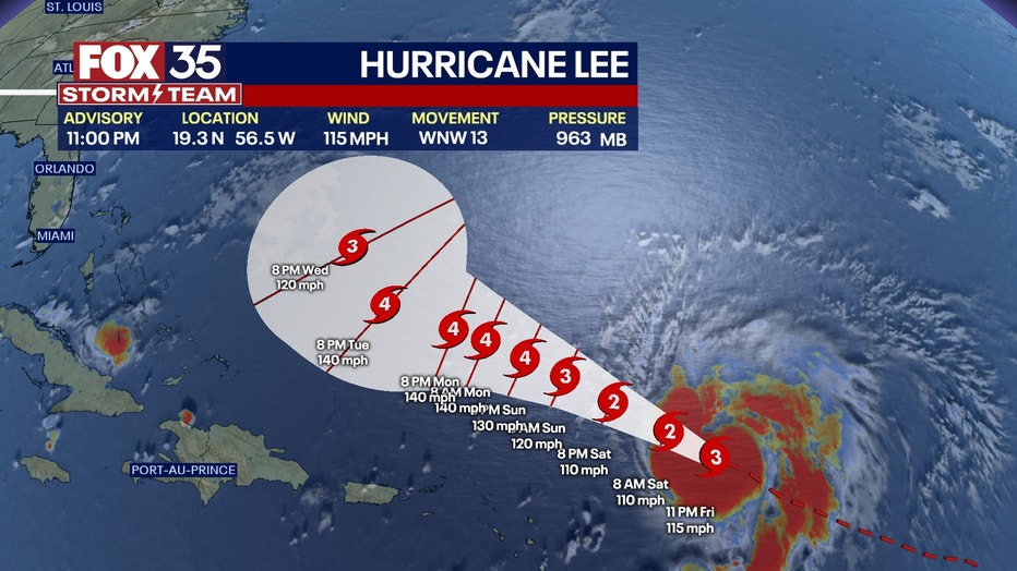
11 a.m advisory | Hurricane Lee is moving in a slow west-northwestward motion and is 270 miles north-northeast of the Northern Leeward Islands. Lee's maximum sustained winds have increased to near 110 mph with higher gusts.
Strengthening is expected during the next couple of days.
Sept. 9 updates below:
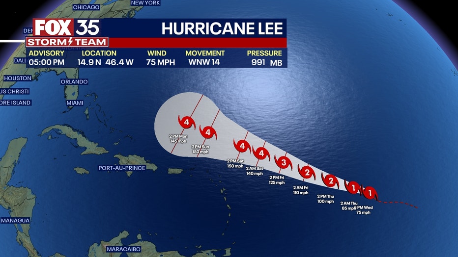
5 p.m. advisory | Hurricane Lee is 310 miles northeast of the Northern Leeward Islands with maximum sustained winds of 115 mph.
Lee is expected to pass well north of the Leeward Islands during the next day, the National Hurricane Center said.
11 a.m. advisory | Lee is maintaining its strength as a Category 3 hurricane it is about 350 miles east-northeast of the Northern Leeward Islands with maximum sustained winds of 115 mph.
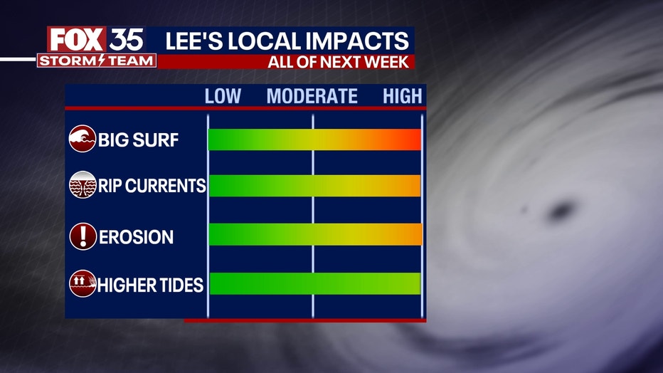
Hazardous beach conditions are expected to develop around the western Atlantic through next week.
Sept. 8 updates below:
11 p.m. advisory | Hurricane Lee has weakened to a category 3 storm but it is still a major hurricane. Hazardous beach conditions are expected to develop around the western Atlantic through next week.
Lee is about 440 miles east of the Northern Leeward Islands with maximum sustained winds of 115 mph.
5 p.m. advisory | Category 4 Hurricane Lee is about 500 miles east of the Northern Leeward Islands with maximum sustained winds of 150 mph.
Lee is moving toward the west-northwest near 13 mph and is expected to pass well to the north of the northern Leeward Islands, the Virgin Islands, and Puerto Rico over the weekend into early next week.
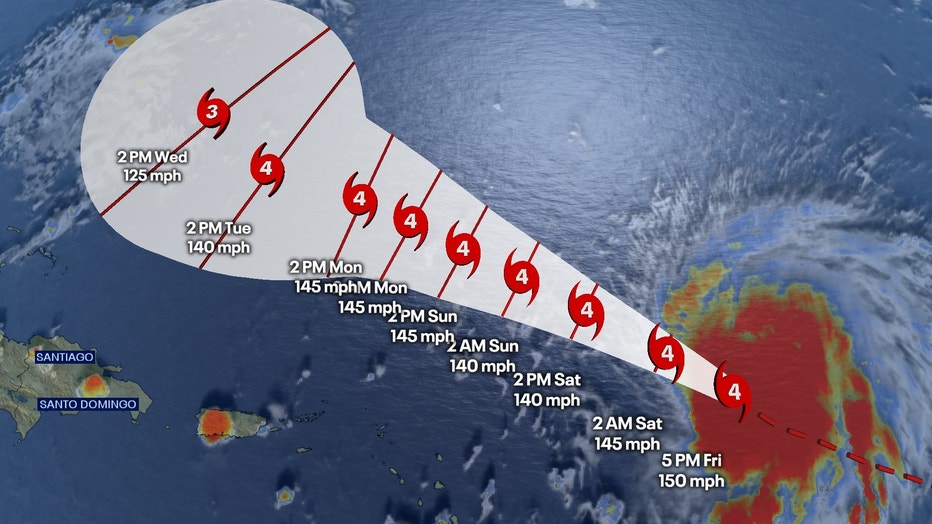
11 a.m. advisory | Hurricane Lee dropped slightly to a Category 4 hurricane with 155 mph sustained winds (Cat. 5 is 157 mph winds or higher), and is expected to remain a "powerful hurricane" as it makes its way across the Atlantic, the National Hurricane Center said.
As of 11 a.m., Lee was about 565 miles east of the northern Leeward Islands with maximum sustained winds of 155 mph – a Cat. 4 hurricane – and was moving west-northwest at 13 mph.
DOWNLOAD THE FOX 35 NEWS APP FOR WEATHER AND NEWS UPDATES
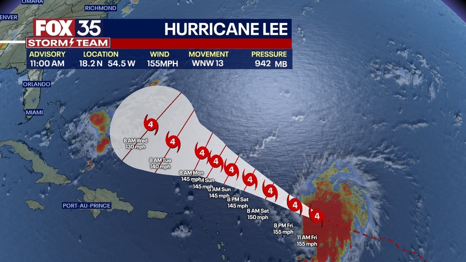
Hurricane Lee is expected to continue to move west-northwest through the weekend and into next week, while also significantly slowing down in speed. The storm will fluctuate in intensity over the next few days, but should remain a powerful storm.
Ocean swells are expected to reach the Lesser Antilles later Friday, and the British and U.S. Virgin Islands, Puerto Rico, Hispaniola, Turks and Caicos, Bahamas, and Bermuda this weekend. Life-threatening surf and deadly rip currents are possible in those areas, as well as along the U.S. eastern coast beginning on Sunday.
Hurricane-force winds extend outward up to 35 miles from the center, while tropical-storm-force winds extend up to 140 miles from Lee's center.
Could Hurricane Lee impact Florida?
It's still too early to know exactly where Hurricane Lee will end up. Most models have Hurricane Lee shifting north as it approaches Florida.
Regardless, as early as Sunday, the National Hurricane Center said it expects those along Florida's coastlines to see increases in surf, waves, and dangerous rip currents, which means people visiting the beaches will need to be extra cautious.
9:42 a.m. | The Hurricane Hunters flew through the eye of Hurricane Lee Thursday night, and shared video and images of that flight on Friday morning.
The video shows several flashes of lightning throughout the storm, as well as the storm's forming eye wall.
5 a.m. advisory | Hurricane Lee is expected to maintain its Cat. 5 intensity.
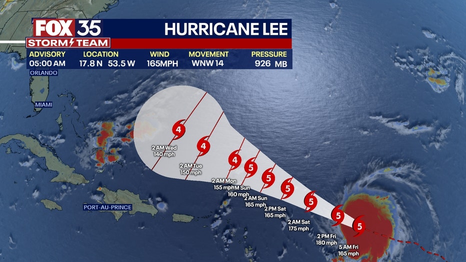
Fluctuations in intensity are likely over the next few days, but Lee is expected to remain a major hurricane through early next week", the National Hurricane Center said.

Sept. 7 updates below:
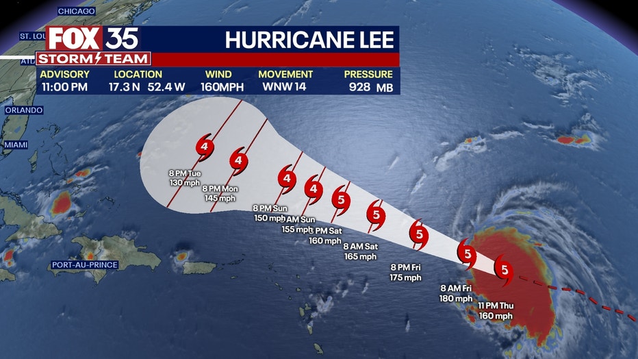
11 p.m. advisory | Hurricane Lee has become a Category 5 hurricane with dangerous beach conditions expected to develop around the western Atlantic through early next week.
Lee is about 705 miles east of the Northern Leeward Islands with maximum sustained winds of 160 mph.
Additional strengthening is expected overnight.
5 p.m. advisory | Hurricane Lee has strengthened to a Category 4 hurricane and had maximum sustained winds of 130 mph. Lee is about 780 miles east of the Northern Leeward Islands.
Lee is moving west-northwest at 15 mph and will be moving in this direction for the next several days while gradually slowing down its forward speed, the NHC said.
Additional strengthening is expected Thursday night with Lee forecast to remain a powerful major hurricane into next week.
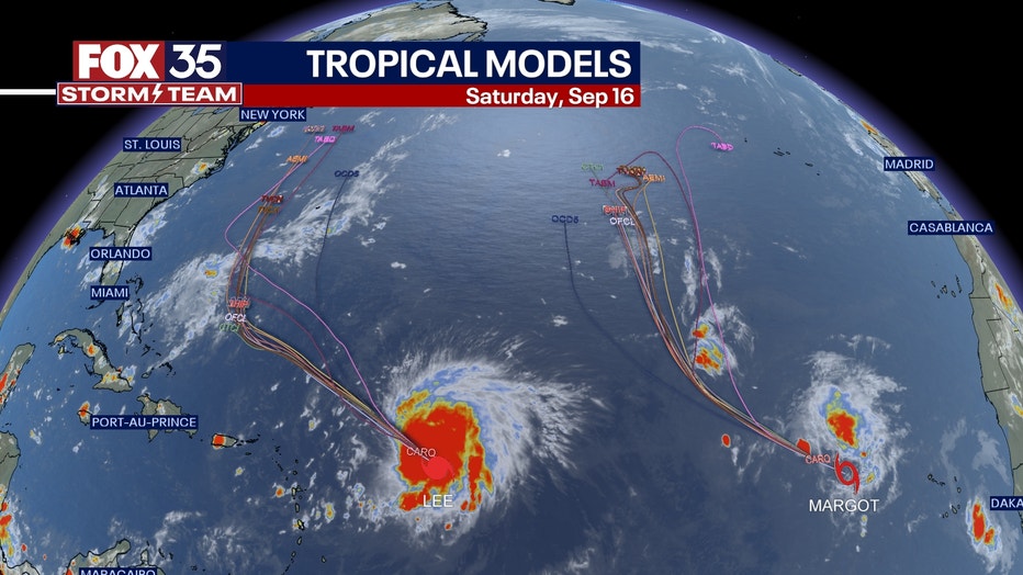
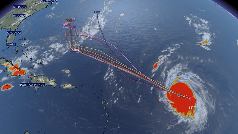
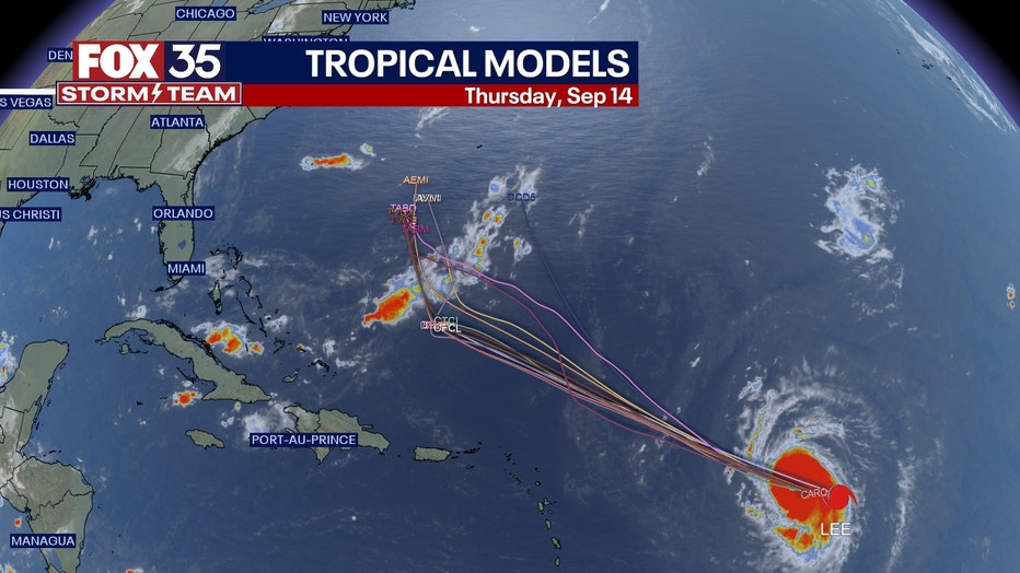
Hurricane Lee spaghetti models
11 a.m. advisory | Hurricane Lee strengthened to a Category 2 hurricane and has maximum sustained winds of 105 mph, the National Hurricane Center said. It's forecast to become a monster Category 5 hurricane by Friday, before weakening to a still-dangerous Category 4 storm.
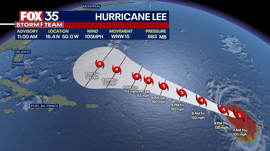
Hurricane Lee is expected to rapidly strengthen later Thursday and Friday, becoming a major hurricane, which is considered to be a Category 3 storm or higher. It's expected to "remain a very strong major hurricane through the weekend."
Lee is located about 870 miles east of the northern Leeward Islands and is moving west-northwest at 15 mph. The minimum central pressure is 983 mb.
5 a.m. advisory | Hurricane Lee will undergo rapid intensification later today and is forecast to become a major hurricane by early Friday.
Lee is located about 965 miles east of the northern Leeward Islands with maximum sustained winds of 80 mph.
Lee is moving toward the west-northwest near 14 mph and this motion is expected to continue through Friday.
Forecast models show a sweeping northerly turn with Hurricane Lee by next week, roughly around Wednesday into Thursday. Nearly all models show this. The future steering of Lee will depend on Atlantic high pressure and a front that will stage along the Atlantic seaboard.
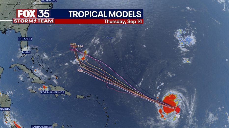
Lee should find a path between these two features longer term. Still advising everyone from Florida, all the way up the Atlantic States to remain updated through the duration of Lee's passage.
Sept. 6 updates below:
11 p.m. advisory | Hurricane Lee is located about 1035 miles east of the northern Leeward Islands with maximum sustained winds that have increased to almost 80 mph.
Lee is moving toward the west-northwest near 14 mph with a slower motion toward the west-northwest expected over the weekend.
Additional strengthening is expected and rapid intensification is expected to begin on Thursday, the NHC said.
Swells generated by Hurricane Lee are expected to reach parts of the Lesser Antilles on Friday and reach the British and U.S. Virgin Islands, Puerto Rico, Hispaniola, the Bahamas, and Bermuda this weekend.
The NCH said the swells are likely to cause life-threatening surf and rip current conditions.
Lee could become a major hurricane by early Friday.
Hurricane Lee forms
Hurricane Lee formed early Wednesday in the Atlantic, where it is expected to rapidly strengthen into an "extremely dangerous" Category 4 hurricane as early as this weekend, according to the National Hurricane Center.
While it's not known where exactly Hurricane Lee will ultimately travel, it's expected to bring large ocean wells and life-threatening rip currents to portions of the Lesser Antilles islands, the British and U.S. Virgin Islands, and Puerto Rico this weekend. Here are live updates on Hurricane Lee's path, cone, direction, spaghetti models, and potential impacts to Florida or the U.S. eastern coast.

Hurricane Lee forms in the Atlantic
Hurricane Lee has formed in the Atlantic and is expected to intensify into a category 4 hurricane
5 p.m. advisory | Hurricane Lee was located about 1,130 miles east of the Northward Leeward Islands with maximum sustained winds of 75 mph, making it a Category 1 hurricane.
The storm is moving west-northwest at 14 mph and this motion is expected to continue for the next few days, the NHC said. It's then expected to intensify into an "extremely dangerous" category 4 hurricane – minimum 135 mph sustained winds – by early Saturday.
It's expected to bring life-threatening ocean swell and rip currents to portions of the Lesser Antilles Islands, U.S. and British Virgin Islands, and Puerto Rico by this weekend.
Hurricane Lee track: Where is Hurricane Lee right now?
Where is Hurricane Lee expected to hit? Is it headed towards Florida?
It's still too soon to tell exactly where Hurricane Lee will ultimately end up. However, the FOX 35 Storm Team is continuing to track its developments.
Potential impacts right now could include a rise in seas and surf, as well as dangerous rip currents along the eastern coast and beaches.