


Warm and muggy with chance of storms for Tuesday
Rich Luterman has the forecast.
Rich Luterman has the forecast.

A muggier and wetter week lies ahead of us!
Scattered showers and an isolated thunderstorm return to today's forecast.
Scattered showers and an isolated thunderstorm return to today's forecast.

Hot and Dry Sunday
Expect highs this afternoon to surge into the upper 80s and low 90s. Thankfully we will keep things dry this afternoon. More humidity and better rain and storm chances are back by midweek.
Expect highs this afternoon to surge into the upper 80s and low 90s. Thankfully we will keep things dry this afternoon. More humidity and better rain and storm chances are back by midweek.

90s For Sunday
Air Quality Alert is on again for Sunday. Limit outdoor activities if you have respiratory concerns. Above average temperatures continue this week with increasing chances for rain. Meteorologist Lori Pinson has your forecast
Air Quality Alert is on again for Sunday. Limit outdoor activities if you have respiratory concerns. Above average temperatures continue this week with increasing chances for rain. Meteorologist Lori Pinson has your forecast

Hotter Sunday
Warmer temperatures tomorrow, near 90. Still dry with the next chance for rain Monday. Meteorologist Lori Pinson has your forecast.
Warmer temperatures tomorrow, near 90. Still dry with the next chance for rain Monday. Meteorologist Lori Pinson has your forecast.

Bark on Biddle 6
FOX 2 News at 6
FOX 2 News at 6

Bark on Biddle 5
FOX 2 News at 6
FOX 2 News at 6

Bark on Biddle 4
FOX 2 News at 5
FOX 2 News at 5

Bark on Biddle 3
FOX 2 News at 5
FOX 2 News at 5

Bark on Biddle 2
FOX 2 News at 5
FOX 2 News at 5

Bark on Biddle 1
FOX 2 News at 5
FOX 2 News at 5

Sunny and Warm Saturday
Highs should top out near 90 degrees this afternoon with a southwest breeze between 10 to 20 mph.
Highs should top out near 90 degrees this afternoon with a southwest breeze between 10 to 20 mph.

Air Quality Alert Saturday
Ground level ozone cooking under a strong June sun with warmer than average temperatures has prompted an Air Quality Alert Saturday. Limit time outdoors if you have respiratory concerns. Meteorologist Lori Pinson has your forecast
Ground level ozone cooking under a strong June sun with warmer than average temperatures has prompted an Air Quality Alert Saturday. Limit time outdoors if you have respiratory concerns. Meteorologist Lori Pinson has your forecast

A few Friday showers with a summer weekend on tap!
Mostly dry Friday -- totally dry this weekend!
Mostly dry Friday -- totally dry this weekend!

Getting warmer with the heat hitting this weekend
Rich Luterman has the forecast.
Rich Luterman has the forecast.

Showers over today... hot this weekend
A heat wave is on the way for SE MI.
A heat wave is on the way for SE MI.

The warm up is coming! But first, a bit of rain lingers.
High temps make it back into the 70's this afternoon.
High temps make it back into the 70's this afternoon.
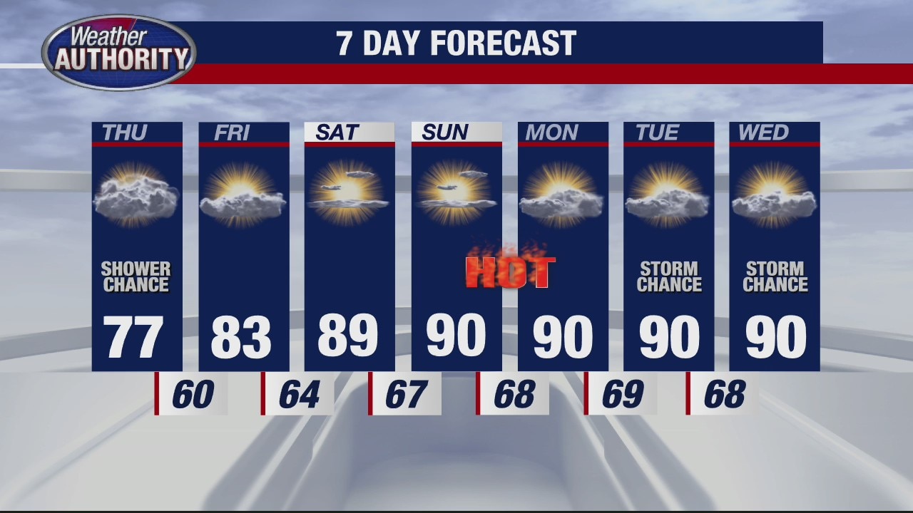
Chance of rain Thursday before heat up happens
Rich Luterman has the forecast.
Rich Luterman has the forecast.

A brief midweek cool down with a hot weekend on the way!
Rain moves in this afternoon
Rain moves in this afternoon

Comfy temps with a chance for rain Wednesday
Rich Luterman has the forecast.
Rich Luterman has the forecast.