


Inside the Better Made Chips Factory in Detroit
FOX 2 News Weekend
FOX 2 News Weekend

Meet Zeus!
FOX 2 News Weekend
FOX 2 News Weekend

Breezy and Warm Sunday
Expect another breezy and warm day today with winds at times gusting over 20 mph. After a mostly sunny start this morning, expect clouds to quickly increase into the afternoon and evening with highs topping out in the upper 70s and low 80s. After sunset, our rain chances will also start to increase. Scattered rain is expected overnight into Monday. Have your umbrellas ready to go to start the workweek just to be safe. Highs temperatures will only make it into the upper 60s on Monday with cooler air expected as we round out the week.
Expect another breezy and warm day today with winds at times gusting over 20 mph. After a mostly sunny start this morning, expect clouds to quickly increase into the afternoon and evening with highs topping out in the upper 70s and low 80s. After sunset, our rain chances will also start to increase. Scattered rain is expected overnight into Monday. Have your umbrellas ready to go to start the workweek just to be safe. Highs temperatures will only make it into the upper 60s on Monday with cooler air expected as we round out the week.

Cooler, Rainy Weather On The Way
Meteorologist Lori Pinson has your forecast
Meteorologist Lori Pinson has your forecast

Meet Toby!
FOX 2 News Weekend
FOX 2 News Weekend

Meet Miles!
FOX 2 News Weekend
FOX 2 News Weekend

Warm Weekend
Expect temperatures this weekend to soar into the low 80s for highs with lots of sunshine on Saturday. More clouds and a few rain chances move in on Sunday. Much cooler air is on the way into the next workweek with highs slipping and falling into the 60s before bottoming out by week's end in the 50s for highs.
Expect temperatures this weekend to soar into the low 80s for highs with lots of sunshine on Saturday. More clouds and a few rain chances move in on Sunday. Much cooler air is on the way into the next workweek with highs slipping and falling into the 60s before bottoming out by week's end in the 50s for highs.

Nice warm weekend ahead
Big changes coming next week!
Big changes coming next week!

Meet Razzy!
The Nine
The Nine

Warm Fall Weekend Ahead
If you like the warm air, you are going to love everything about today and this weekend. Temperatures are expected to surge to near 80 today and into the 80s both Saturday and Sunday. Enjoy it while it lasts because much cooler, fall air will pour into southeast Michigan by next week. High temperatures are forecast in the 60s to start the week with temperatures plummeting into the 50s for highs by the end of next week.
If you like the warm air, you are going to love everything about today and this weekend. Temperatures are expected to surge to near 80 today and into the 80s both Saturday and Sunday. Enjoy it while it lasts because much cooler, fall air will pour into southeast Michigan by next week. High temperatures are forecast in the 60s to start the week with temperatures plummeting into the 50s for highs by the end of next week.

Friday forecast perfection. The warm stuff keeps coming!
Near 80? weather through the weekend.
Near 80? weather through the weekend.

Still warm but a cool down is coming
Rich Luterman has the forecast.
Rich Luterman has the forecast.

Warm weather takes us into the weekend!
Rain stays away for a while too.
Rain stays away for a while too.

Warm trend continues
Rich Luterman has the forecast.
Rich Luterman has the forecast.

Nice week continues
High temps near 80 and dry to end the work week
High temps near 80 and dry to end the work week

The midweek warm up is here! Near 80 this afternoon.
The warmth will stick through the week.
The warmth will stick through the week.
Warm temps continue during pleasant stretch
Rich Luterman has the forecast.
Rich Luterman has the forecast.

First Day of Fall Forecast
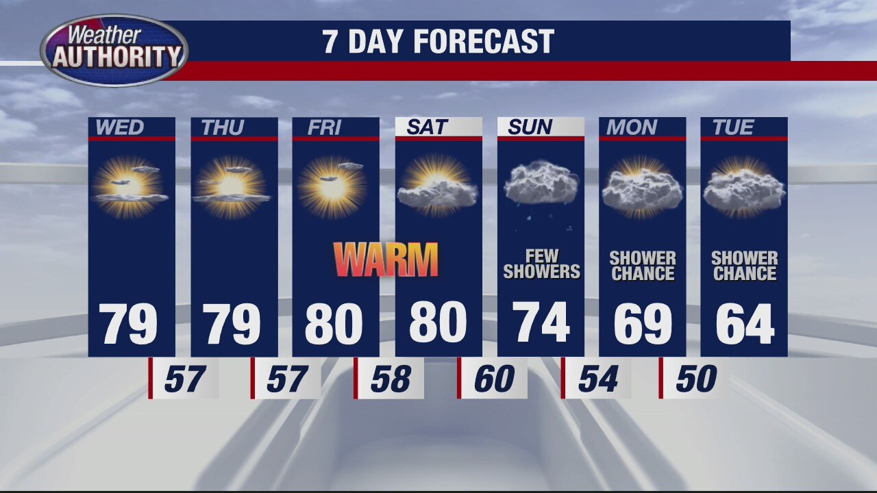
Autumn officially begins today and with it, you will notice that fall like coolness to the air this morning. Into this afternoon, we are expecting more sunshine with some haziness due to the wildfires out west. High temperatures should top out in the mid 70s. We will fall into the low and mid 50s overnight. Near 80 degree heat is back by Wednesday, Thursday, Friday and Saturday. Our next best chance for showers rolls in late weekend on Sunday.
Autumn officially begins today and with it, you will notice that fall like coolness to the air this morning. Into this afternoon, we are expecting more sunshine with some haziness due to the wildfires out west. High temperatures should top out in the mid 70s. We will fall into the low and mid 50s overnight. Near 80 degree heat is back by Wednesday, Thursday, Friday and Saturday. Our next best chance for showers rolls in late weekend on Sunday.

A nice warm start to the fall season! Temps make a run toward 80.
Fall begins at 9:31 am.
Fall begins at 9:31 am.
Meet Penney!
The Nine
The Nine