


Chilly Weekend
A cold start to your Saturday with below seasonal temperatures trending through the weekend. Warmer air by mid week. Meteorologist Lori Pinson has your forecast.
A cold start to your Saturday with below seasonal temperatures trending through the weekend. Warmer air by mid week. Meteorologist Lori Pinson has your forecast.

Rain on and off for weekend, but milder temps are coming
Lori Pinson has the forecast.
Lori Pinson has the forecast.
A chilly weekend with some showers
Temperature moderation expected next week.
Temperature moderation expected next week.

Morning Flurries and Breezy Friday
Temperatures will be much colder today than yesterday. Along with the cooler air will come a few flurries this morning. Little to no accumulation is expected. If you are traveling to northern Michigan, more accumulating snow is expected. Highs will only make it into the upper 30s and low 40s this afternoon. 40s with rain chances are in our forecast this weekend in Metro Detroit.
Temperatures will be much colder today than yesterday. Along with the cooler air will come a few flurries this morning. Little to no accumulation is expected. If you are traveling to northern Michigan, more accumulating snow is expected. Highs will only make it into the upper 30s and low 40s this afternoon. 40s with rain chances are in our forecast this weekend in Metro Detroit.
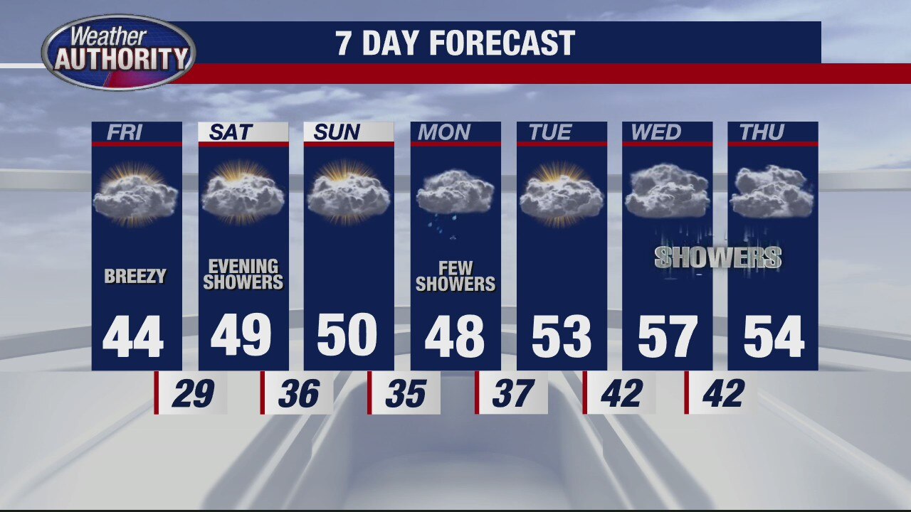
Cool and breezy for Friday
Rich Luterman has the forecast.
Rich Luterman has the forecast.

Strong winds continue until at least 2PM
Conditions stay breezy tonight as temps plummet.
Conditions stay breezy tonight as temps plummet.

Damaging Winds Possible Thursday Morning
Strong possibly damaging winds are possible this morning and early this afternoon in Metro Detroit. Wind gusts could exceed 40 to 50 mph along with light rain showers. Temperatures are also expected to fall through the day. You'll wake up to temperatures in the 50s and 60s but by your drive home from work, expect temperatures in the 40s. A few snowflakes are possible on Friday.
Strong possibly damaging winds are possible this morning and early this afternoon in Metro Detroit. Wind gusts could exceed 40 to 50 mph along with light rain showers. Temperatures are also expected to fall through the day. You'll wake up to temperatures in the 50s and 60s but by your drive home from work, expect temperatures in the 40s. A few snowflakes are possible on Friday.

Wind Advisory overnight with some rain Thursday
Rich Luterman has the forecast.
Rich Luterman has the forecast.
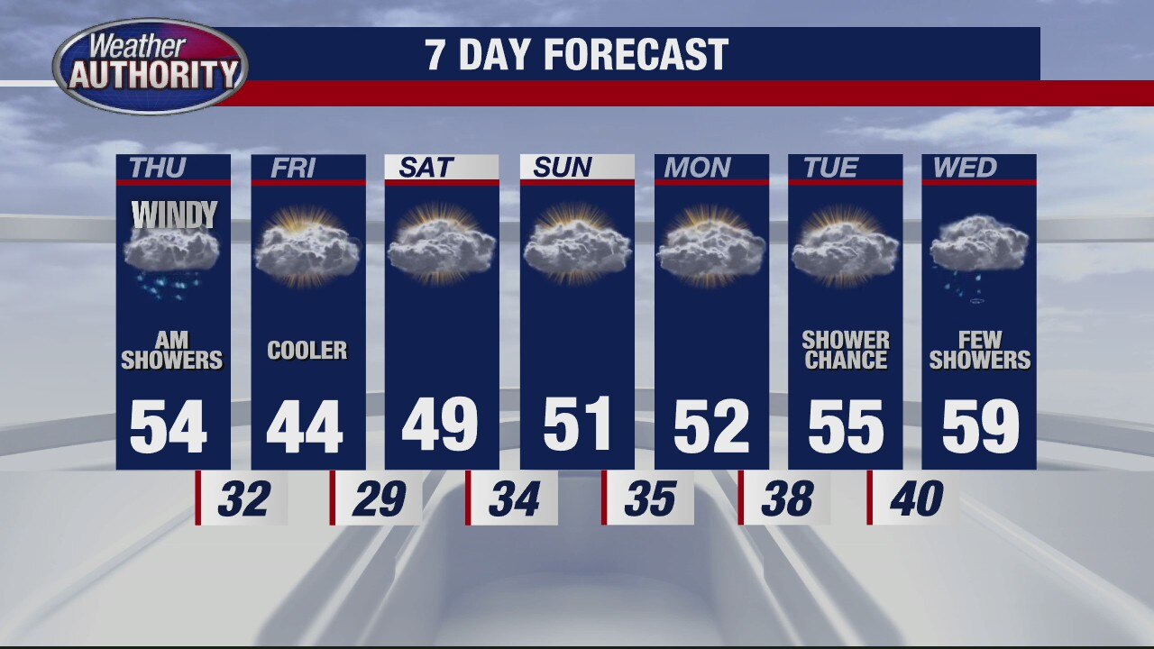
Blustery with some early rain Thursday
Rich Luterman has the forecast.
Rich Luterman has the forecast.

Warmer air coming our way
But the showers still stick around
But the showers still stick around

Slick Spots Wednesday Morning
Freezing Rain is possible this morning! That will lead to slick and slippery spots especially on bridges, overpasses, on-ramps and off-ramps. Temperatures will eventually warm above freezing by late morning. By this afternoon, highs will surge into the 50s before topping out near 60 degrees this evening. Rain and wind is expected tonight and through the day tomorrow.
Freezing Rain is possible this morning! That will lead to slick and slippery spots especially on bridges, overpasses, on-ramps and off-ramps. Temperatures will eventually warm above freezing by late morning. By this afternoon, highs will surge into the 50s before topping out near 60 degrees this evening. Rain and wind is expected tonight and through the day tomorrow.

Wintery mix overnight - then warmer temps
Rich Luterman has the forecast.
Rich Luterman has the forecast.

Cold temps stick around for one more day
Rich Luterman has the forecast.
Rich Luterman has the forecast.
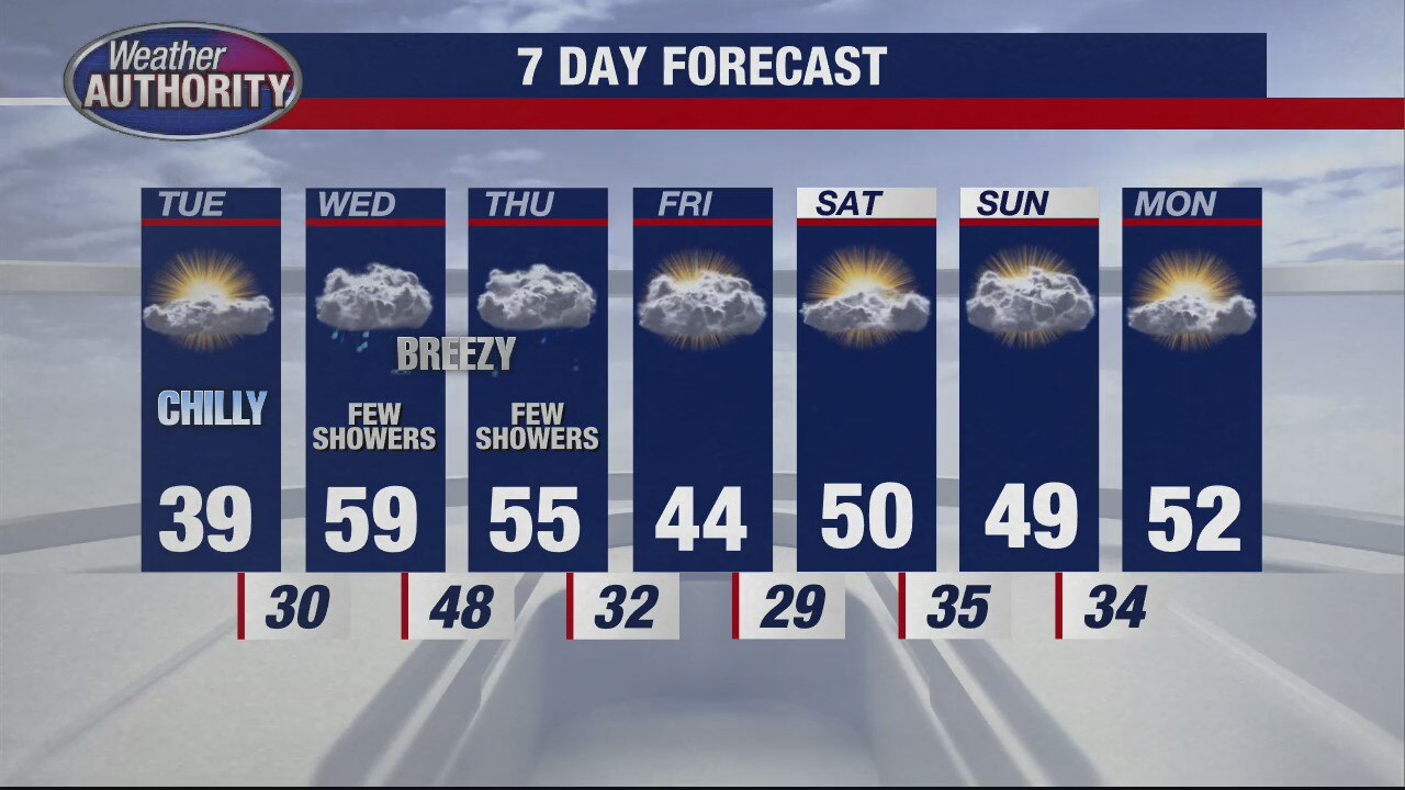
Still cold for Tuesday
Rich Luterman has the forecast.
Rich Luterman has the forecast.
Sunday Morning Snow Flurries
Although we're tracking snow flurries this morning, expect more clouds, more wind and more cold air this afternoon. The lake effect snow flurries should wind down around lunchtime today with highs only in the upper 20s and low 30s.
Although we're tracking snow flurries this morning, expect more clouds, more wind and more cold air this afternoon. The lake effect snow flurries should wind down around lunchtime today with highs only in the upper 20s and low 30s.

Preventing Ticks and Fleas this Spring Season
The one and only, Mike Palmer, from Premier Pet Supply joined us to talk about what we can do to help prevent ticks and fleas from jumping on our furry friends as we head into the spring and summer months.
The one and only, Mike Palmer, from Premier Pet Supply joined us to talk about what we can do to help prevent ticks and fleas from jumping on our furry friends as we head into the spring and summer months.
A cold weekend continues
More light snowflakes are possible too.
More light snowflakes are possible too.

Saturday Morning Snow Showers
Get your snow gear ready! More morning snow showers are on this way this morning. The snow should begin to taper by late morning. In total, we should pick up between a trace to 1" of snow with a couple spots picking up a little more than 1 inch. Bridges, overpasses, on-ramps and off-ramps could get slick and slippery.
Get your snow gear ready! More morning snow showers are on this way this morning. The snow should begin to taper by late morning. In total, we should pick up between a trace to 1" of snow with a couple spots picking up a little more than 1 inch. Bridges, overpasses, on-ramps and off-ramps could get slick and slippery.

Snow for Saturday
Rain moving in Friday night will transition to snow into Saturday morning. Meteorologist Lori Pinson has your forecast
Rain moving in Friday night will transition to snow into Saturday morning. Meteorologist Lori Pinson has your forecast
Light Snow Saturday
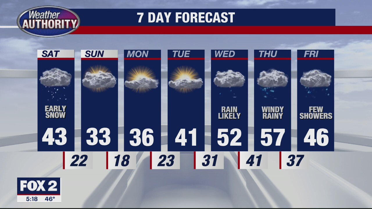
Although it's spring, we carry the threat of light snow Saturday with much colder air in place Sunday. Meteorologist Lori Pinson has your forecast
Although it's spring, we carry the threat of light snow Saturday with much colder air in place Sunday. Meteorologist Lori Pinson has your forecast