


Chilly Weekend Ahead
Have your hats, coats and scarfs ready to go this weekend. Though our normal high temperature is 40 degrees for this time of the year, expect temperatures stuck in the 30s in Metro Detroit this weekend. Thankfully, accumulating snow is not in our forecast, but a few flurries could be seen from time to time. We should top out in the mid to upper 30s today under partly cloudy skies before falling in to the upper 20s overnight. Check out the highlights on what is expected to be a major snowstorm up the east coast this weekend.
Have your hats, coats and scarfs ready to go this weekend. Though our normal high temperature is 40 degrees for this time of the year, expect temperatures stuck in the 30s in Metro Detroit this weekend. Thankfully, accumulating snow is not in our forecast, but a few flurries could be seen from time to time. We should top out in the mid to upper 30s today under partly cloudy skies before falling in to the upper 20s overnight. Check out the highlights on what is expected to be a major snowstorm up the east coast this weekend.

Colder Weekend, Warmer Mid Week
A cold front changes our wind direction allowing cooler air for the weekend. Meteorologist Lori Pinson has your forecast
A cold front changes our wind direction allowing cooler air for the weekend. Meteorologist Lori Pinson has your forecast
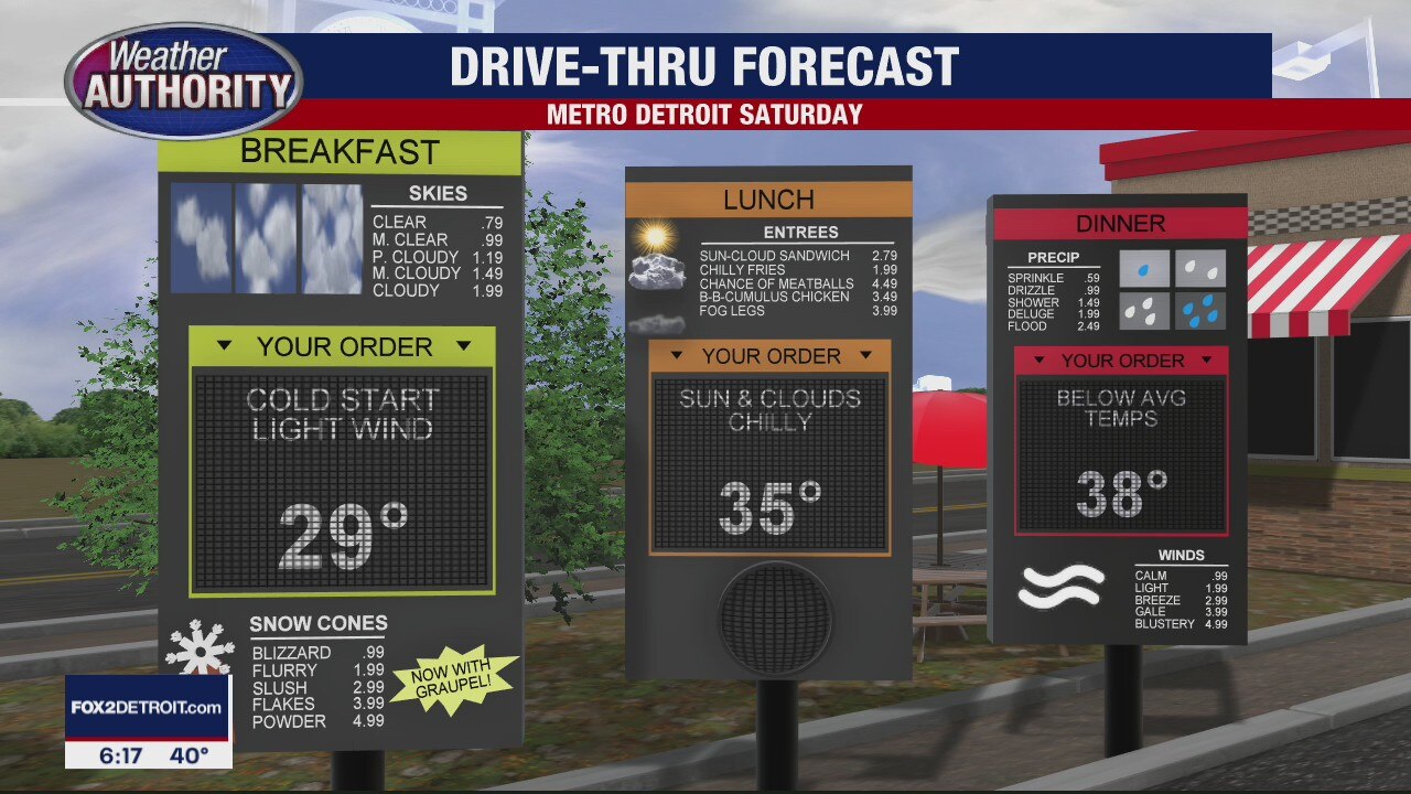
Colder Weekend Ahead
Meteorologist Lori Pinson has your forecast
Meteorologist Lori Pinson has your forecast

Friday flurries but a warm-up next week
Rich Luterman has the forecast.
Rich Luterman has the forecast.

Some flurries for Friday
Rich Luterman has the forecast.
Rich Luterman has the forecast.
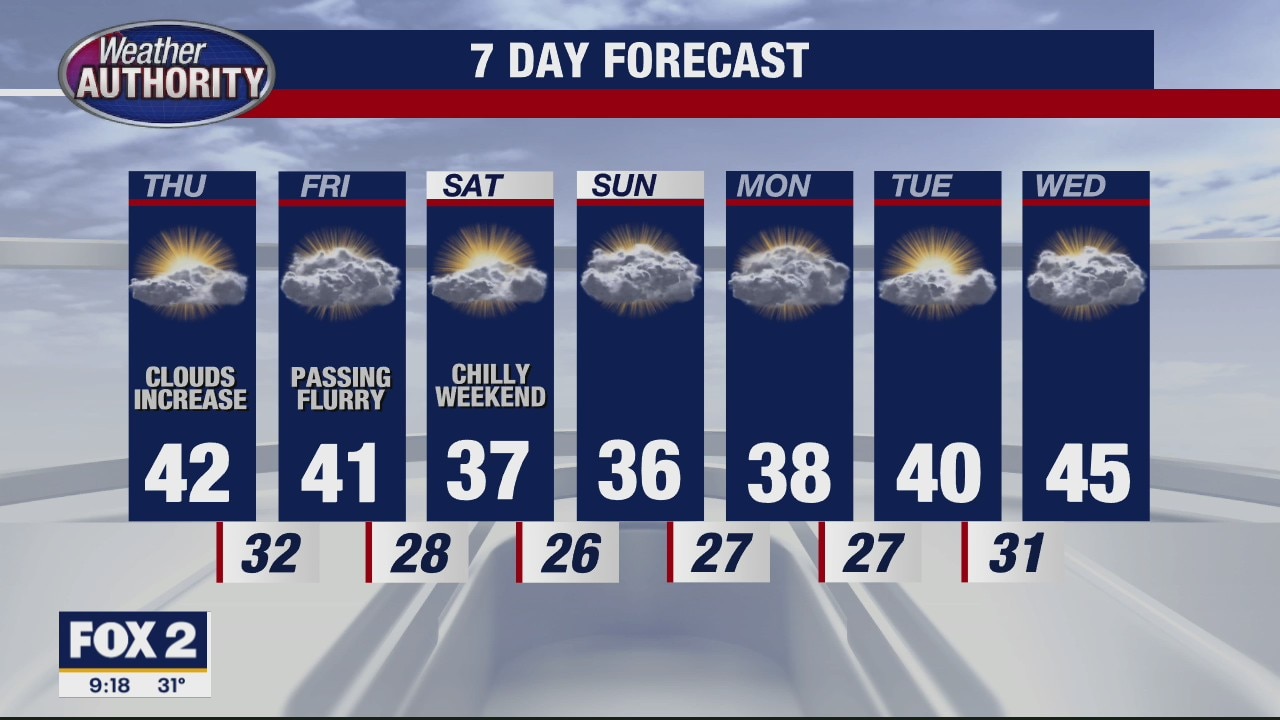
Clouds increasing today
We begin with more sunshine but end with more clouds.
We begin with more sunshine but end with more clouds.

Thursday skies start bright, finish cloudy. We'll go colder for the weekend.
High temps Saturday and Sunday fade into the 30's.
High temps Saturday and Sunday fade into the 30's.
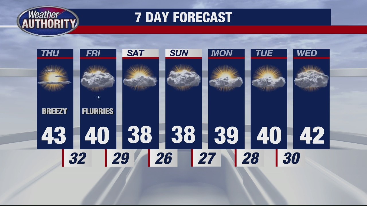
Partly cloudy and cool for Thursday
Rich Luterman has the forecast.
Rich Luterman has the forecast.

Sunny and cool trend continues
Rich Luterman has the forecast.
Rich Luterman has the forecast.

The snow's done and the sun's coming back!
Brighter skies and slightly milder temps are coming.
Brighter skies and slightly milder temps are coming.
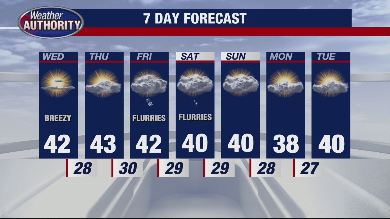
Still brisk and cool for Wednesday
Rich Luterman has the forecast.
Rich Luterman has the forecast.
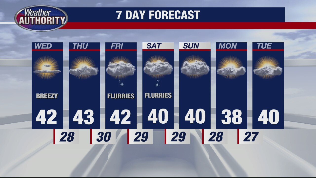
Getting a little warmer for mid-week
Rich Luterman has the forecast.
Rich Luterman has the forecast.
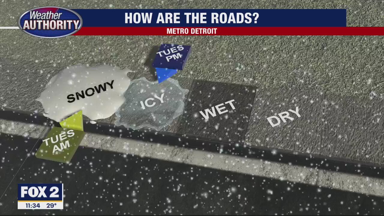
Icy Roads Tonight
Snowy roads coupled with below freezing temperatures tonight could bring icy conditions. Mini warmup is on the way. Meteorologist Lori Pinson has your forecast!
Snowy roads coupled with below freezing temperatures tonight could bring icy conditions. Mini warmup is on the way. Meteorologist Lori Pinson has your forecast!

Snow Tapering Off
As Low pressure moves away, the snow will recede. Expect at least another inch of snow, gusty winds and reduced visibility before it's all over. Meteorologist Lori Pinson has your forecast.
As Low pressure moves away, the snow will recede. Expect at least another inch of snow, gusty winds and reduced visibility before it's all over. Meteorologist Lori Pinson has your forecast.

We're not done with the snow just yet
A Winter Weather Advisory continues until noon for most of SE Michigan.
A Winter Weather Advisory continues until noon for most of SE Michigan.

Snowy Monday
Meteorologist Lori Pinson has your forecast
Meteorologist Lori Pinson has your forecast

Winter Weather Advisory: Rain changes to snow
Rain/snow will shift to snow by afternoon!
Rain/snow will shift to snow by afternoon!

Rare Views inside Detroit's Masonic Temple
FOX 2 News Weekend
FOX 2 News Weekend

Sunny Sunday with Snow on the way
Enjoy the upper 40s and low 50s along with the sunshine today because accumulating snowfall is expected Monday afternoon and through the day on Tuesday. At this point, we are expecting between 2 and 4 inches of snowfall by Tuesday night with localized higher amounts. Be on the lookout for a Winter Weather Advisory to be issued either later today or on Monday. Make sure you have your snow shovels, snow boots and salt ready to go.
Enjoy the upper 40s and low 50s along with the sunshine today because accumulating snowfall is expected Monday afternoon and through the day on Tuesday. At this point, we are expecting between 2 and 4 inches of snowfall by Tuesday night with localized higher amounts. Be on the lookout for a Winter Weather Advisory to be issued either later today or on Monday. Make sure you have your snow shovels, snow boots and salt ready to go.

Quiet Sunday, Changes Monday
Meteorologist Lori Pinson has your forecast
Meteorologist Lori Pinson has your forecast