


Rain Snow Mix Sunday
Expect a rain to snow mix through your Sunday with winds gusting at times over 30 mph. No significant accumulation is expected. Temperatures will tumble from the 40s in the morning through the 30s during the majority of the afternoon. A freezing cold night is ahead of us with lows in the 20s. 60s are in the 7 day.
Expect a rain to snow mix through your Sunday with winds gusting at times over 30 mph. No significant accumulation is expected. Temperatures will tumble from the 40s in the morning through the 30s during the majority of the afternoon. A freezing cold night is ahead of us with lows in the 20s. 60s are in the 7 day.

Bright Halloween. Rain and Snow Sunday
Enjoy the sunshine today along with the mid and upper 40s today. If you are taking the little ones trick or treating, it should be a great evening for it with temps in the 40s along with mostly clear skies. Rain and snow move in on Sunday. Temps should start in the in the 40s and will fall through the 30s during the afternoon.
Enjoy the sunshine today along with the mid and upper 40s today. If you are taking the little ones trick or treating, it should be a great evening for it with temps in the 40s along with mostly clear skies. Rain and snow move in on Sunday. Temps should start in the in the 40s and will fall through the 30s during the afternoon.

A chilly weekend but dry on Halloween
Some snow is possible on Sunday though
Some snow is possible on Sunday though

Windy Weekend Ahead
Expect more clouds and cool temps today with highs only in the mid 40s. After a freezing cold night with overnight lows in the mid and upper 20s, we are expecting more sunshine on Halloween Saturday with highs nearing 50 degrees. Rain chances do return on Sunday.
Expect more clouds and cool temps today with highs only in the mid 40s. After a freezing cold night with overnight lows in the mid and upper 20s, we are expecting more sunshine on Halloween Saturday with highs nearing 50 degrees. Rain chances do return on Sunday.

Cool stretch coming up
Rich Luterman has the forecast.
Rich Luterman has the forecast.

Brisk for Friday
Rich Luterman has the forecast.
Rich Luterman has the forecast.
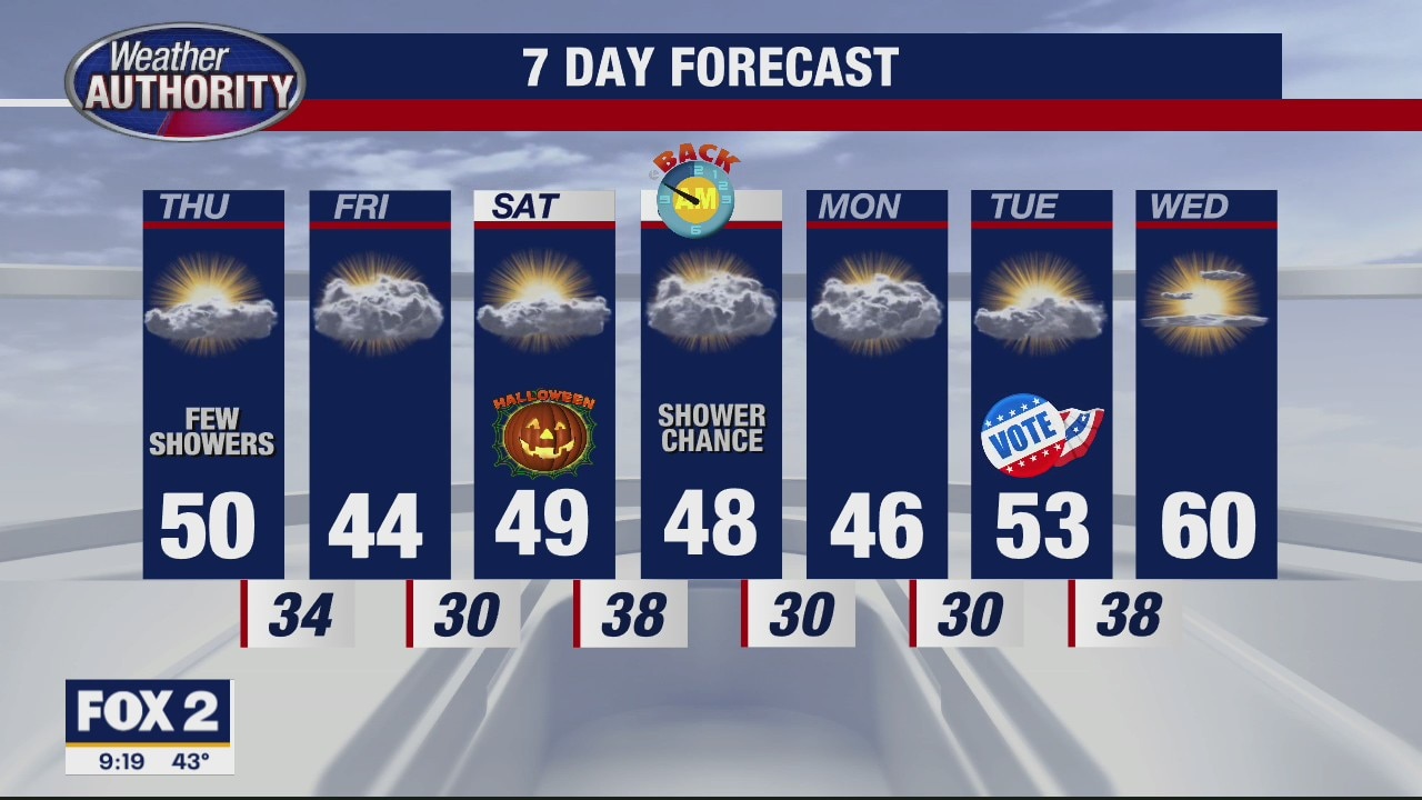
Most of us remain dry this Thursday
Halloween looks nice too (but cool)
Halloween looks nice too (but cool)

Clouds are coming back, with a few Thursday showers. Your Halloween forecast is still coming in A-OK!
Decent sun with highs near 50 Saturday.
Decent sun with highs near 50 Saturday.

No rain in sight during upcoming stretch
Rich Luterman has the forecast.
Rich Luterman has the forecast.

Clouds fade, sun returns! Halloween weather still looks dry.
Conditions are a little less harsh today.
Conditions are a little less harsh today.

Sunny and dry for Wednesday
Rich Luterman has the forecast.
Rich Luterman has the forecast.

Mild for Wednesday
Rich Luterman has the forecast.
Rich Luterman has the forecast.

Some light sprinkles today
A nicer, sunnier day tomorrow!
A nicer, sunnier day tomorrow!

More clouds and keeping it cool. Passing shower possible, but the sun's coming back tomorrow!
High temps in the 40's for another day.
High temps in the 40's for another day.

Trying Dunkin Donuts New Spicy Ghost Pepper Donut
FOX 2 News Weekend
FOX 2 News Weekend

Cloudy and Cool Monday
Watch out for a few pockets of mist and drizzle as you are heading out the door on Monday. We are expecting temperatures only in the mid and upper 40s this afternoon under cloudy skies. Through this afternoon, be on the lookout for a stray shower from time to time. Temperatures are expected to fall into the 30s overnight. Thankfully, more sun is in our forecast by Wednesday along with more mid temps. As we head toward the Halloween holiday, look for more sunshine and cooler air.
Watch out for a few pockets of mist and drizzle as you are heading out the door on Monday. We are expecting temperatures only in the mid and upper 40s this afternoon under cloudy skies. Through this afternoon, be on the lookout for a stray shower from time to time. Temperatures are expected to fall into the 30s overnight. Thankfully, more sun is in our forecast by Wednesday along with more mid temps. As we head toward the Halloween holiday, look for more sunshine and cooler air.

Cool Temps, Scattered Showers
Meteorologist Lori Pinson has your forecast
Meteorologist Lori Pinson has your forecast

Not As Cold Tonight
Meteorologist Lori Pinson has your forecast
Meteorologist Lori Pinson has your forecast

Heidelberg Project
Armed with a paintbrush, a local Detroit artist has transformed vacant lots and abandon homes into a world-renowned art project. Michael Estime introduces you to the Heidelberg Project?s Tyree Guyton.
Armed with a paintbrush, a local Detroit artist has transformed vacant lots and abandon homes into a world-renowned art project. Michael Estime introduces you to the Heidelberg Project?s Tyree Guyton.

Chilly Sunday Funday
Grab your jackets, hats, gloves and mask before you head out today. We will start this morning with temperatures around freezing. Light frost will be an issue in a few spots. Mostly cloudy skies should dominate not only this morning, but also this afternoon with highs only in the upper 40s. We should be in the upper 50s for this time of the year. We should stay dry during the day. There is a slight chance for a stray shower overnight into early Monday. The workweek looks cool, so make sure you have your winter coats ready to go.
Grab your jackets, hats, gloves and mask before you head out today. We will start this morning with temperatures around freezing. Light frost will be an issue in a few spots. Mostly cloudy skies should dominate not only this morning, but also this afternoon with highs only in the upper 40s. We should be in the upper 50s for this time of the year. We should stay dry during the day. There is a slight chance for a stray shower overnight into early Monday. The workweek looks cool, so make sure you have your winter coats ready to go.