


Cooler and less windy Thursday, 70's set to come back tomorrow!
A warm weekend is on the way.
A warm weekend is on the way.

Mild stretch coming up
Rich Luterman has the forecast.
Rich Luterman has the forecast.

Windy and warm Wednesday. Even warmer for the weekend!
A few showers early this morning will fade.
A few showers early this morning will fade.

Great week continues
Warm and dry for about 7 more days
Warm and dry for about 7 more days

Meet Ranger!
The Nine
The Nine

Mostly Sunny and Breezy Tuesday
Although we are off to a cool start this morning, expect more sunshine this afternoon with highs jumping into the mid and upper 60s. Winds could make things a little tricky out on the water as well. Wind gusts at times could exceed 20 to 25 MPH. Though a cold front is going to swing through today, it will be a dry front, so no rain is in our forecast locally. Temperatures will fall into the mid 50s overnight. Not only are we in the upper 60s for highs at the end of this workweek, but we are forecasting 70s just in time for this weekend.
Although we are off to a cool start this morning, expect more sunshine this afternoon with highs jumping into the mid and upper 60s. Winds could make things a little tricky out on the water as well. Wind gusts at times could exceed 20 to 25 MPH. Though a cold front is going to swing through today, it will be a dry front, so no rain is in our forecast locally. Temperatures will fall into the mid 50s overnight. Not only are we in the upper 60s for highs at the end of this workweek, but we are forecasting 70s just in time for this weekend.

Tuesday warm up!
Partly sunny skies and well into the 60's by afternoon.
Partly sunny skies and well into the 60's by afternoon.

A cool start to a dry week
Temps climb through the week getting into the 70s
Temps climb through the week getting into the 70s
Meet Grady!
The Nine
The Nine
Cool Monday Sunshine
After a foggy start this morning, we are expecting that sunshine to burn off by late morning and eventually warm up the temperatures into the upper 50s. We will tumble into the mid 40s overnight. Warmer temperatures are expected by tomorrow with highs in the mid to upper 60s. 70s are back by this upcoming weekend.
After a foggy start this morning, we are expecting that sunshine to burn off by late morning and eventually warm up the temperatures into the upper 50s. We will tumble into the mid 40s overnight. Warmer temperatures are expected by tomorrow with highs in the mid to upper 60s. 70s are back by this upcoming weekend.

A chilly start to the day but temps are moving up! Near 70 by Wednesday.
Rain stays away for a while.
Rain stays away for a while.

Light Rain Sunday
Grab an umbrella if you are up and out the door early this morning. We are tracking light rain showers throughout much of Metro Detroit. We will hang on to the light rain through mid afternoon before things begin to taper into the evening hours. Severe weather is not expected. It will be cool with highs today only in the mid 50s. Thankfully, more sunshine is in store on Monday with warmer air moving in by midweek.
Grab an umbrella if you are up and out the door early this morning. We are tracking light rain showers throughout much of Metro Detroit. We will hang on to the light rain through mid afternoon before things begin to taper into the evening hours. Severe weather is not expected. It will be cool with highs today only in the mid 50s. Thankfully, more sunshine is in store on Monday with warmer air moving in by midweek.
Showers For Sunday
Meteorologist Lori Pinson has your forecast
Meteorologist Lori Pinson has your forecast

Evening Update
Meteorologist Lori Pinson has your forecast
Meteorologist Lori Pinson has your forecast
Meet Archer!
FOX 2 News Weekend
FOX 2 News Weekend

Cool Saturday
You are waking up this morning to a few areas of patchy frost. It is one of the reasons why a Frost Advisory is in effect until 8 AM. By mid morning, we are expecting partly cloudy skies with temperatures eventually jumping from the 30s into the mid 50s by the afternoon. Below normal high temps are forecast today and Sunday. Rain will make a return to southeast Michigan during the overnight hours and more so into Sunday. Have your umbrella on standby if you plan on being out and about tomorrow. More mild air will finally return by the middle of next week.
You are waking up this morning to a few areas of patchy frost. It is one of the reasons why a Frost Advisory is in effect until 8 AM. By mid morning, we are expecting partly cloudy skies with temperatures eventually jumping from the 30s into the mid 50s by the afternoon. Below normal high temps are forecast today and Sunday. Rain will make a return to southeast Michigan during the overnight hours and more so into Sunday. Have your umbrella on standby if you plan on being out and about tomorrow. More mild air will finally return by the middle of next week.

Meet Rosco!
The Nine
The Nine
Cool Weekend Ahead
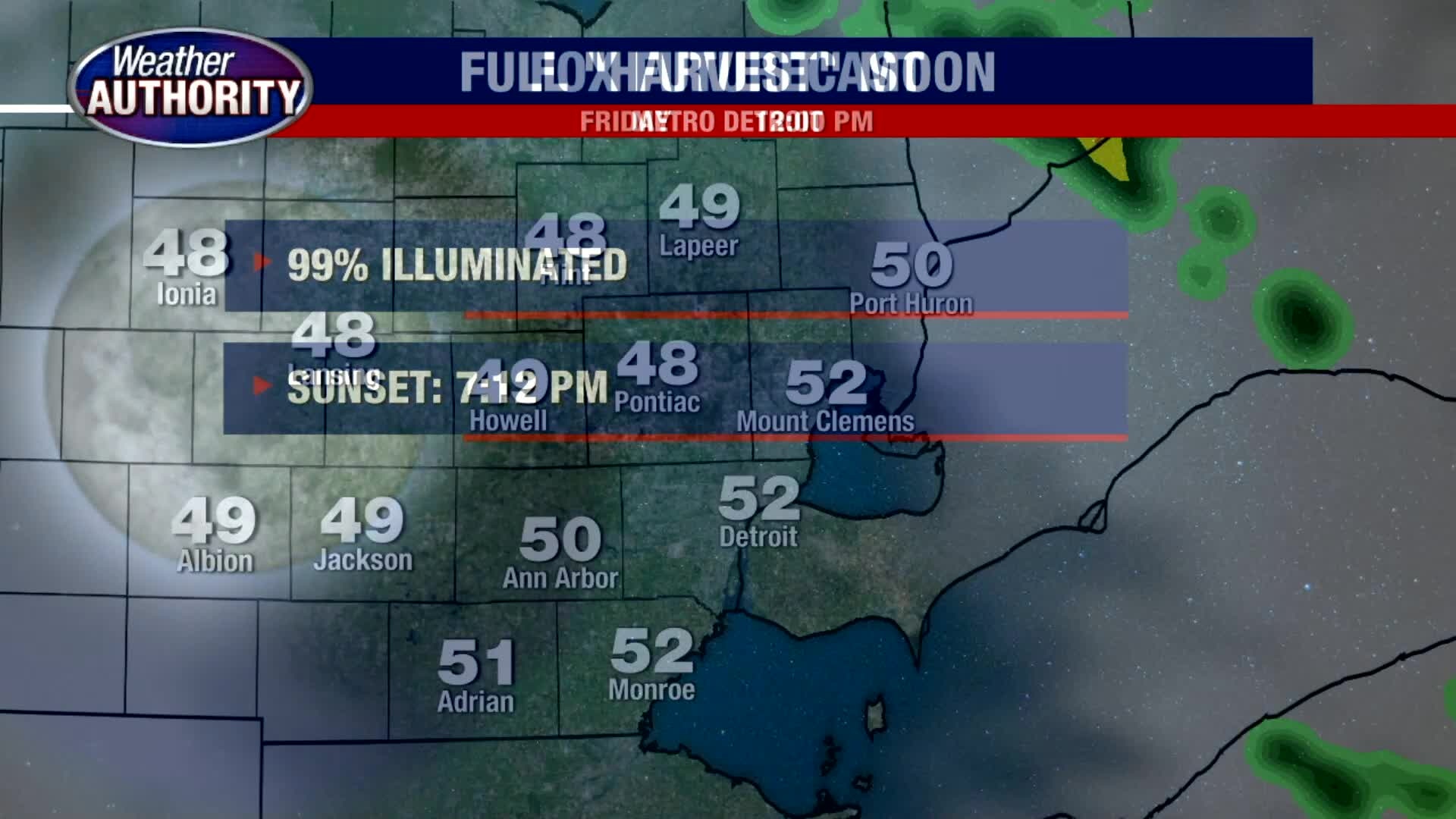
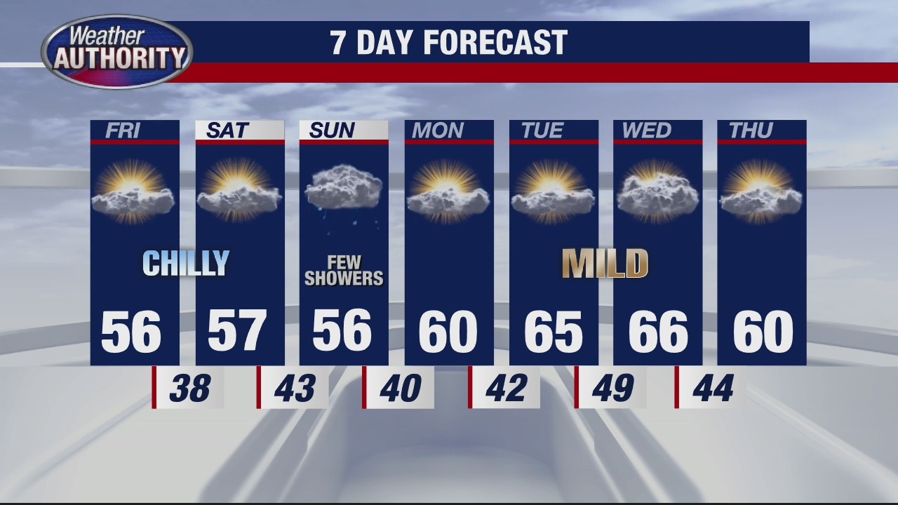
Expect a cool Friday and weekend ahead with temperatures only in the mid 50s for highs. Frost is possible overnight with temperatures tumbling into the upper 30s/low 40s in the city. Outside of the city, temperatures should fall to the mid 30s which could produce areas of frost. It might not be a bad idea to cover up your sensitive outdoor plants. Though we could see a few rain showers on Sunday, a pattern shift to warmer air will move in by the middle of next week with highs back in the mid 60s.
Expect a cool Friday and weekend ahead with temperatures only in the mid 50s for highs. Frost is possible overnight with temperatures tumbling into the upper 30s/low 40s in the city. Outside of the city, temperatures should fall to the mid 30s which could produce areas of frost. It might not be a bad idea to cover up your sensitive outdoor plants. Though we could see a few rain showers on Sunday, a pattern shift to warmer air will move in by the middle of next week with highs back in the mid 60s.

Friday chill! Temps are down through the weekend.
The 60's coming back next week!
The 60's coming back next week!
Cold overnight, but rain ends in time for Friday
Rich Luterman has the forecast.
Rich Luterman has the forecast.