

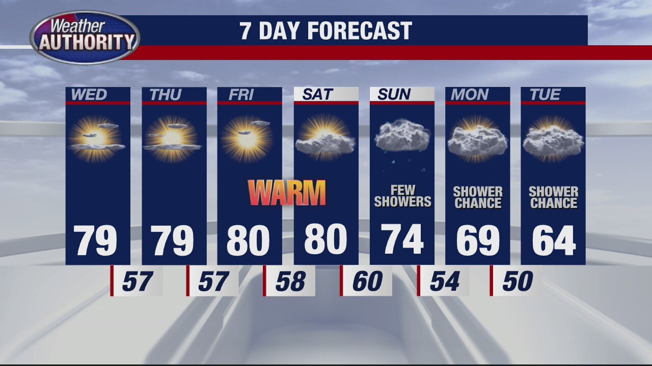
Warm Fall Weekend Ahead
If you like the warm air, you are going to love everything about today and this weekend. Temperatures are expected to surge to near 80 today and into the 80s both Saturday and Sunday. Enjoy it while it lasts because much cooler, fall air will pour into southeast Michigan by next week. High temperatures are forecast in the 60s to start the week with temperatures plummeting into the 50s for highs by the end of next week.
If you like the warm air, you are going to love everything about today and this weekend. Temperatures are expected to surge to near 80 today and into the 80s both Saturday and Sunday. Enjoy it while it lasts because much cooler, fall air will pour into southeast Michigan by next week. High temperatures are forecast in the 60s to start the week with temperatures plummeting into the 50s for highs by the end of next week.

Friday forecast perfection. The warm stuff keeps coming!
Near 80? weather through the weekend.
Near 80? weather through the weekend.

Still warm but a cool down is coming
Rich Luterman has the forecast.
Rich Luterman has the forecast.

Warm weather takes us into the weekend!
Rain stays away for a while too.
Rain stays away for a while too.

Warm trend continues
Rich Luterman has the forecast.
Rich Luterman has the forecast.

Nice week continues
High temps near 80 and dry to end the work week
High temps near 80 and dry to end the work week

The midweek warm up is here! Near 80 this afternoon.
The warmth will stick through the week.
The warmth will stick through the week.
Warm temps continue during pleasant stretch
Rich Luterman has the forecast.
Rich Luterman has the forecast.

First Day of Fall Forecast
Autumn officially begins today and with it, you will notice that fall like coolness to the air this morning. Into this afternoon, we are expecting more sunshine with some haziness due to the wildfires out west. High temperatures should top out in the mid 70s. We will fall into the low and mid 50s overnight. Near 80 degree heat is back by Wednesday, Thursday, Friday and Saturday. Our next best chance for showers rolls in late weekend on Sunday.
Autumn officially begins today and with it, you will notice that fall like coolness to the air this morning. Into this afternoon, we are expecting more sunshine with some haziness due to the wildfires out west. High temperatures should top out in the mid 70s. We will fall into the low and mid 50s overnight. Near 80 degree heat is back by Wednesday, Thursday, Friday and Saturday. Our next best chance for showers rolls in late weekend on Sunday.

A nice warm start to the fall season! Temps make a run toward 80.
Fall begins at 9:31 am.
Fall begins at 9:31 am.
Meet Penney!
The Nine
The Nine
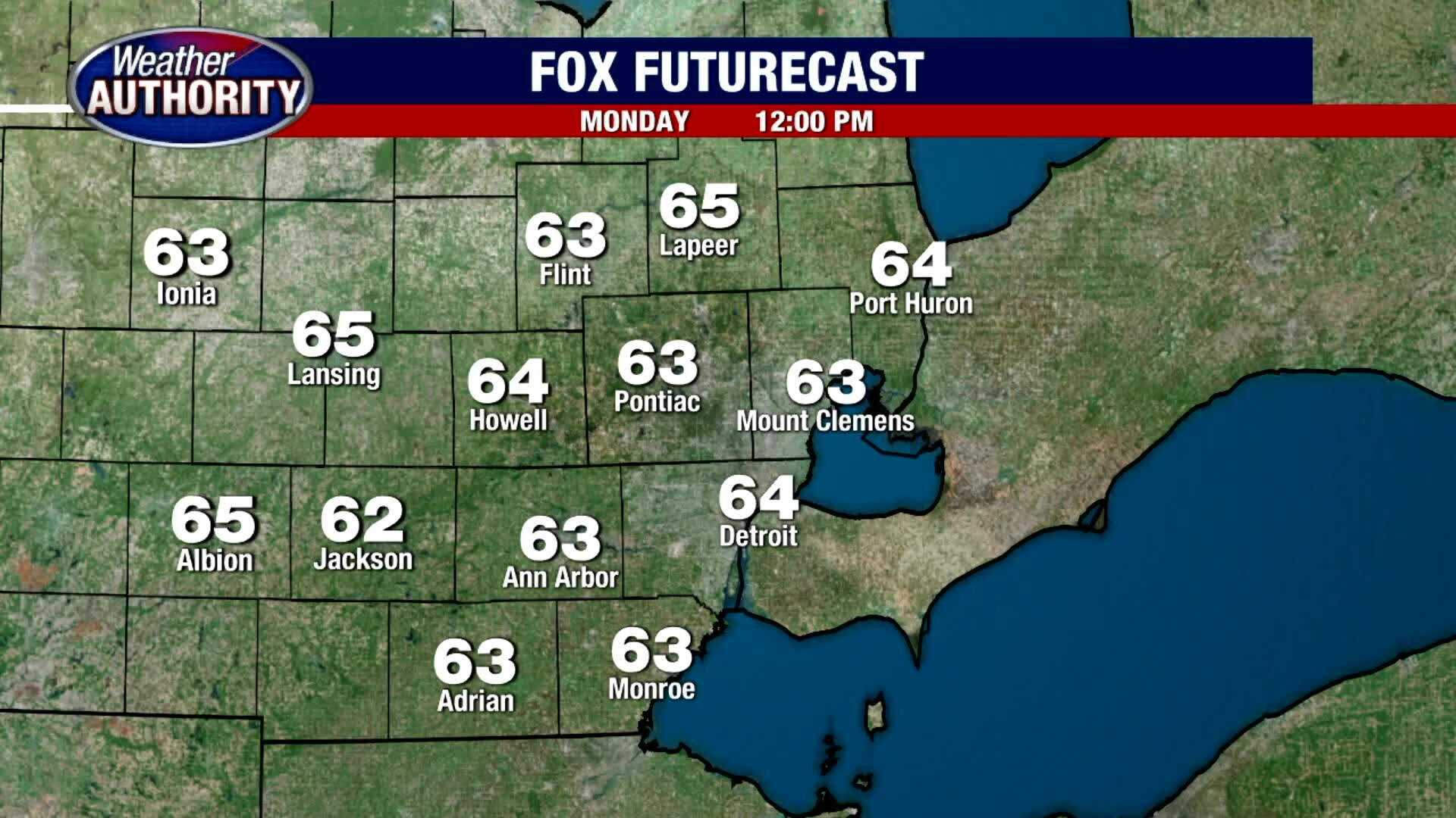
Crisp and Cool Monday
After a comfortably cool start this Monday morning, we are forecasting lots of sunshine and more mild air later this afternoon. Expect highs to eventually jump into the upper 60s to around 70 degrees later today under sunny skies. A little haziness may build in this evening compliments of the wildfires out west. Look for overnight lows to fall into the mid and upper 40s. Near 80 degree heat is back by midweek.
After a comfortably cool start this Monday morning, we are forecasting lots of sunshine and more mild air later this afternoon. Expect highs to eventually jump into the upper 60s to around 70 degrees later today under sunny skies. A little haziness may build in this evening compliments of the wildfires out west. Look for overnight lows to fall into the mid and upper 40s. Near 80 degree heat is back by midweek.

A warmer week on the way!
Closer to 80 midweek.
Closer to 80 midweek.

Meet Tasha!
FOX 2 News Weekend
FOX 2 News Weekend
Meet Nanook!
Meet Nanook!
Meet Nanook!

Meet Buckley!
FOX 2 News Weekend
FOX 2 News Weekend
DTE Expands Solar Parks in Michigan
FOX 2 News Weekend
FOX 2 News Weekend

Cool and Comfy Sunday
Frost Advisories are in place for some of our northern suburbs with temps this morning in the 30s and low 40s. That Frost Advisory will expire by 9am. Temperatures will then climb into the 60s by before topping out in the mid 60s this afternoon under sunny skies. We are expecting a mostly clear night with overnight lows in the upper 40s. Near 80 degree heat is back by the middle of the workweek.
Frost Advisories are in place for some of our northern suburbs with temps this morning in the 30s and low 40s. That Frost Advisory will expire by 9am. Temperatures will then climb into the 60s by before topping out in the mid 60s this afternoon under sunny skies. We are expecting a mostly clear night with overnight lows in the upper 40s. Near 80 degree heat is back by the middle of the workweek.

Patchy Frost Overnight
Meteorologist Lori Pinson has your forecast
Meteorologist Lori Pinson has your forecast

Cold and Frosty Start Saturday
It is a very cold and frosty start this Saturday morning with temperatures outside of the city in the 30s. Near freezing cold temperatures will eventually warm into the 50s by mid morning before topping out in the low 60s under mostly sunny skies. Thankfully, tonight does not look at cold with lows in the 40s. Saturday will be the coldest day of the next 7 with temperatures rising into the upper 70s by the middle of next week.
It is a very cold and frosty start this Saturday morning with temperatures outside of the city in the 30s. Near freezing cold temperatures will eventually warm into the 50s by mid morning before topping out in the low 60s under mostly sunny skies. Thankfully, tonight does not look at cold with lows in the 40s. Saturday will be the coldest day of the next 7 with temperatures rising into the upper 70s by the middle of next week.