

Southeast Michigan severe thunderstorm risk: Strong winds, hail, tornadoes possible this week

Some February severe weather is possible this week
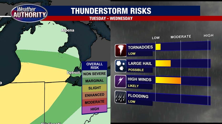
Strong winds, large hail and even the chance for an isolated tornado.
DETROIT (FOX 2) - A rare February severe weather event is possible in Southeast Michigan over the next 48 hours. Let's get right to it.
Typically, when tracking February storm systems, we're talking how many inches of snow, not the inclusion of thunder, lightning and severe weather elements... But such is the case in this rare year. A strong winter system is likely to impact us multiple ways starting early Tuesday morning and picking up again Tuesday evening through Wednesday morning. There will be a few distinct rounds of weather bringing different impacts.

As a warm front lifts through Tuesday morning, we will have atmospheric instability and the chance for a few spotty thunderstorms. These storms could bring gusty winds and medium hail through Tuesday morning hours. As the warm front drags across Michigan on Tuesday afternoon, we may have a brief window of quietness before the most dangerous weather strikes Tuesday evening and Wednesday morning.
It is this window that brings the highest probability for severe weather. Starting around 5 p.m. on Tuesday the possibility for winds gusting to 45 mph, hail up to 1 inch in diameter and an isolated tornado are the primary threats for Southeast Michigan. The window for this severe weather will last until roughly midnight Wednesday morning. The chance for lingering showers and storms, however, lasts through Wednesday morning.
The cold front will pass through in the late morning hours. Wednesday severely dropping our temperatures. Tuesday's highs will be in the low to possibly even middle 60s, and we plummet nearly 30 degrees for an afternoon temperature on Wednesday in the middle 30s.
Overnight lows will drop to 22. Flash freezing of any standing water from the storms is a possibility, creating an icy and slick situation Thursday morning.
Be careful and stay tuned in by watching us all day on Fox 2 or by downloading the Fox 2 Weather App.