

Southeast Michigan Tornado Watch canceled for all
(FOX 2) - The National Weather Service has canceled the tornado watch that was in place for much of Wednesday for southeast Michigan.
The NWS had put the southern portion of Michigan under a watch throughout the day on Wednesday until 4 p.m. But the watch was eventually scaled back to only include Washtenaw, Wayne, Lenawee, and Monroe counties.
By 3:20, the watch was canceled as the storm threat is pushing out of the area.
A watch means conditions are favorable for tornadoes and severe thunderstorms.
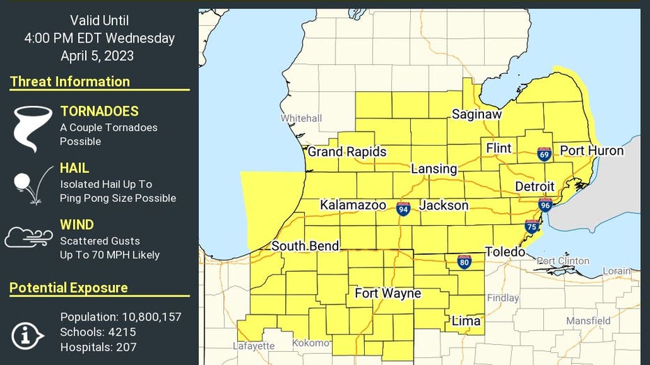
Credit: National Weather Service of Detroit
Temperatures are expected to climb to the warmest they've been all year - near 70 degrees by late afternoon.
MORE: From thunderstorms to tornados, Southeast Michigan facing potential severe weather Wednesday
The high temperatures are what's driving concerns about tornadoes since their formation happens when warm air collides with cooler air. As the two air patterns mix, energy is added to the atmosphere, becoming increasingly unstable.
A good way to think about it is when a latex balloon is inflated. Eventually it will pop. And the bigger the balloon, the bigger the pop.

Strong to severe thunderstorms expected Wednesday in Metro Detroit
There is a possibility of damaging wind gusts, hail, and severe storms Wednesday. Rich Luterman has what to expect.
Morning storms would help peel off some of that energy, and reduce the "pop" that could follow. Fortunately, some rain Wednesday morning had already fallen by the time the tornado watch was ordered.
RELATED: Evaluating Southeast Michigan's tornado risk Wednesday
When the atmosphere is energized by the mixing of warm moist air near the ground and cooler dry air above, an updraft forms from the instability. While most thunderstorms have the necessary ingredients for a tornado, they don't normally intensify to the point of turning violent.
MORE: Strong tornado in Missouri kills, injures multiple people, troopers say
You can also download the FOX 2 Weather app for live radar updates wherever you are. You'll get alerts and updates throughout the day to keep you and your family safe.
How you should prepare for a tornado
Know the difference between Tornado Watch, Tornado Warning
Watches and warnings are different levels of weather alerts.
If a Tornado Watch is issued, it means that you should prepare for tornadic weather. Pay close attention to the forecast.
If a Tornado Warning is issued, it means a tornado is imminent or happening now, and you should take action. In the case of tornadoes, it means you should immediately take shelter in your safe place.
Find your safe place
Before a storm strikes, you should determine the safest place to be in your home in the event of a tornado.
This would be a place on the lowest level, in the center of the floor and away from windows. You want to put as many walls between you and the tornado as possible. An interior closet or hall is best.
HERE'S WHERE TORNADOES ARE MOST LIKELY TO OCCUR IN EACH MONTH
If you live in a mobile home, you should leave well in advance and find a more sturdy building for shelter. If no shelter is nearby, the safest place to be is in a ditch or culvert.
Don’t forget to cover your head. Something like a helmet is best, but anything that can be used to protect your head from flying debris will work.
Check your emergency supplies
In the event of a tornado outbreak, you could lose power or water or both for several days.
The Federal Emergency Management Agency recommends keeping at least a three-day supply of food and water on hand in the event of an emergency.
Your emergency supplies should also include a first aid kit, flashlights, batteries and a whistle to signal for help.
Keep important documents safe
Make sure important documents are kept in a fire-proof and waterproof safe. These documents include birth certificates, titles, Social Security cards and insurance documents.