

Severe storm chances remain, active weather crossing south of Metro Detroit
Severe storms to the south of Metro Detroit, chances for active weather remain
Rich Luterman breaks down our chances for severe weather Tuesday tonight.
FOX 2 - A forecast of active weather remains for Metro Detroit, but some of the heaviest bands of storms are moving south of us.
The backstory:
A ground stop has been issued at Detroit Metropolitan Airport due to thunderstorms according to the FAA, as of 6:30 p.m.
Departure traffic is delayed until about 7:30 p.m. Arrival traffic is experiencing airborne delays of 15 minutes or less.
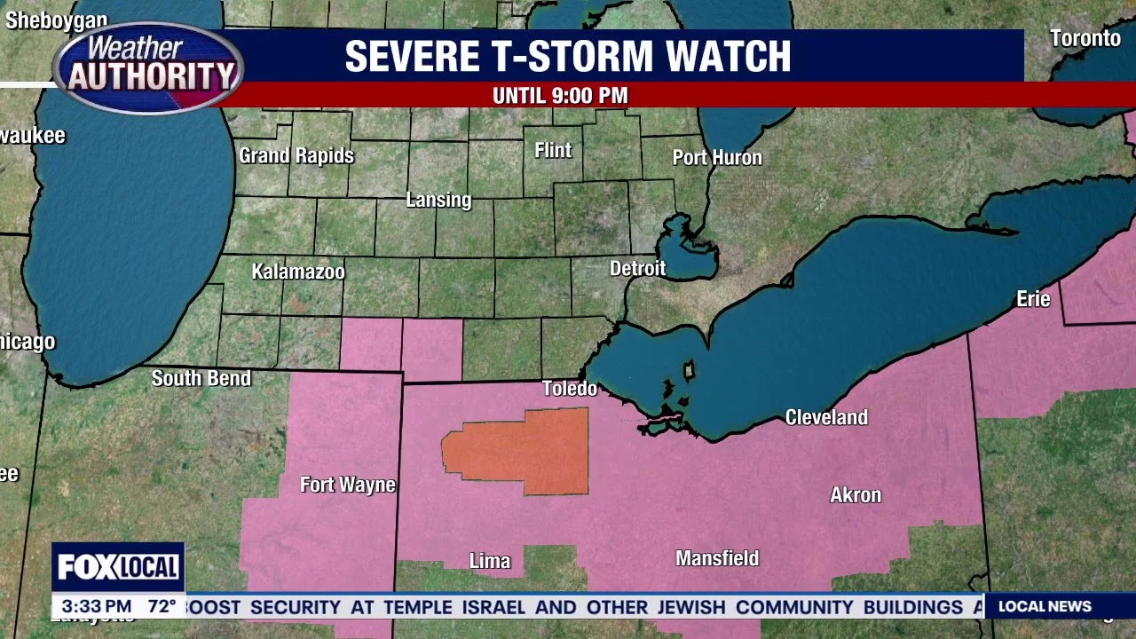
Weather Authority Rich Luterman said that one strong thunderstorm is moving across Monroe County as of 3:30 p.m. That same storm leads into northern Ohio which looks like it will get the brunt of it.
"For Toledo and a little bit south of Toledo, they are definitely going to get some downpours and heavy winds," Luterman said. "We are right on the northern flank - Monroe County is getting a bit of the heavy storms."
A cold front is expected to cross the area around midnight, which may lead to some brief active weather.
There is still a chance for STRONG thunderstorms this evening, then COOLER for Wednesday.
Expect a few thunderstorms with breezy conditions and some rain, Luterman said.
It will be mostly cloudy, with a high near 70. West southwest wind around 17 mph, with gusts as high as 26 mph. Chance of precipitation is 70%.
New rainfall amounts between a tenth and quarter of an inch, except higher amounts possible in thunderstorms.
Tonight: Showers and possibly a thunderstorm before 2 a.m., then a slight chance of showers between 2 a.m. and 3 a.m. Some of the storms could produce heavy rainfall.
The low will be around 40. West southwest wind will be 8 to 13 mph, becoming north after midnight. Winds could gust as high as 24 mph.
Chance of precipitation is 80%. New precipitation amounts between a half and three quarters of an inch possible.
The forecast for the Tigers Home Opener looks promising – Friday. Some showers are likely Saturday with COOLER air returning Easter Sunday.
For the rest of Tuesday evening/night. Occasional t-showers through midnight breeze, low 42
Wednesday: Cloudy and cooler with spotty showers and a high of 47.
Thursday: Mostly cloudy with a milder afternoon temperature. There is a chance for late-evening thunderstorms and a high of 72.
Friday - TIGERS HOME OPENER - partly cloudy and pleasant with a high of 72.
Saturday: Cloudy with rain showers and a high near 70.
Easter Sunday: Mostly cloudy, breezy and cooler with a high of 48
Monday: Sun and clouds and a high of 52.

The Source: Information for this report is from Weather Authority Rich Luterman and the National Weather Service.