

Weekly forecast: Temperatures in the 70s and some rain showers to start the week

Early week: Clouds hang tough another day as temperatures begin their upward climb.
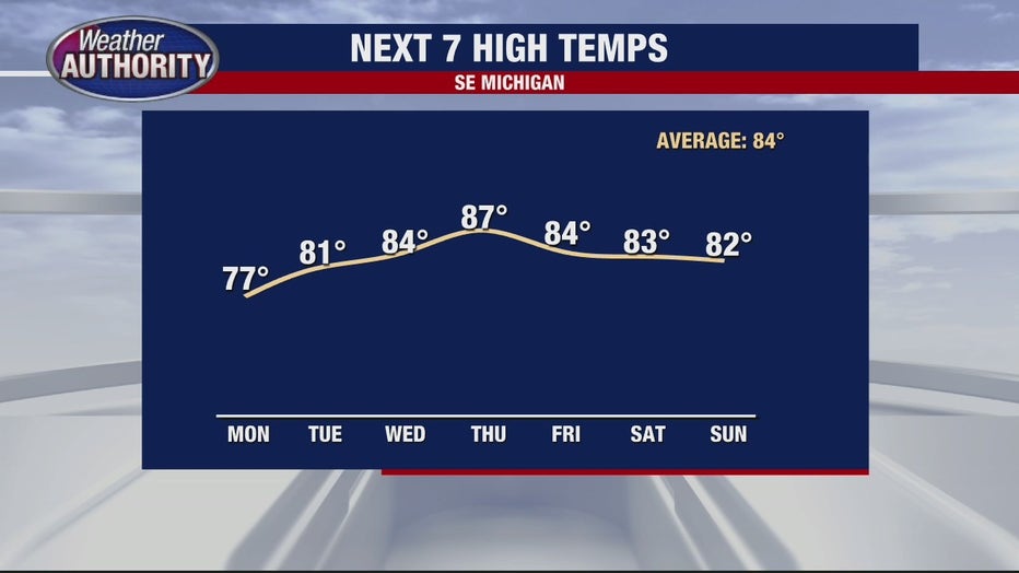
High temps today should settle into the mid 70's which is still below average (84°) but noticeably above our Sunday high temp of 68°.
We will catch some rain showers, but I think on more of an isolated to scattered basis so not everybody will get the wet weather which will include an isolated thunderstorm. Locally heavy rain and an isolated wind gust to 50 mph can't be ruled out with any storms that are able to get going this afternoon.
A few showers and storms will be around tonight and possibly even Tuesday morning with wider coverage of storms set to develop Tuesday afternoon/evening.
Midweek: By Wednesday our early-week system is east of us with our next weather maker approaching which should lead to a mainly if not totally dry day.
Late week: Thursday we should be off to a dry start with storms developing sometime Thursday afternoon or evening. The cold front that will spark those storms looks to be hung up over SE Michigan keeping storms in the forecast Friday.
Want breaking news straight to your phone? Curious about events happening this weekend? Download the FOX 2 News app and the FOX 2 Weather app for iOS and Android today.
Weekend: There are, of course, some differences looking at the long-range models with regard to the weekend's forecast, but at this point, I'm calling for dry weather both Saturday and Sunday with high temps in the 80's. which I think qualifies as a nice summer weekend.