


Paczki Run 2022 Part 3
FOX 2 News Weekend
FOX 2 News Weekend


Paczki Run 2022 Part 2
FOX 2 News Weekend
FOX 2 News Weekend


Paczki Run 2022
FOX 2 News Weekend
FOX 2 News Weekend
Few Flurries Saturday with Afternoon Sun
After a chilly start this Saturday morning along with a few flurries, partly sunny skies are expected this afternoon. Highs should top out in the low 30s with more sunshine on the way on Sunday.
After a chilly start this Saturday morning along with a few flurries, partly sunny skies are expected this afternoon. Highs should top out in the low 30s with more sunshine on the way on Sunday.

Back to the 30s
After a cold start, temperatures Saturday will moderate into the 30s. Still a bit below average but welcome after Friday's highs in the 20s. Meteorologist Lori Pinson has your forecast
After a cold start, temperatures Saturday will moderate into the 30s. Still a bit below average but welcome after Friday's highs in the 20s. Meteorologist Lori Pinson has your forecast

Slightly Milder Weekend
Snow showers are tapering off this evening, replaced by mostly cloudy skies. Slightly milder temperatures this weekend. Meteorologist Lori Pinson has the rest of your forecast
Snow showers are tapering off this evening, replaced by mostly cloudy skies. Slightly milder temperatures this weekend. Meteorologist Lori Pinson has the rest of your forecast

Snowy and Icy Friday Morning
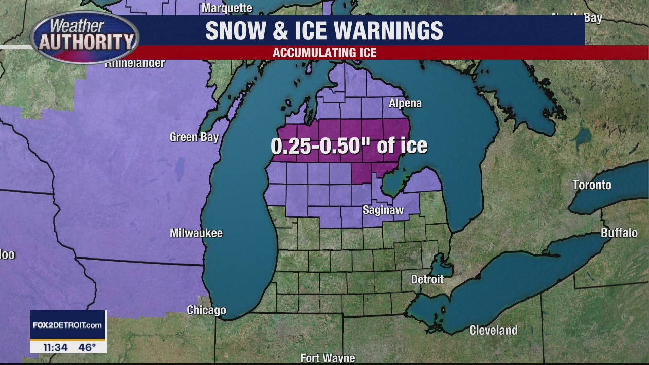
Friday, February 25, 2022: AM Snow & Freezing Drizzle Snow showers and freezing mist/drizzle is a big problem this Friday morning leading to lots of slick/slippery spots on our area roadways. In total, we should pick up between 1 to 3"+ of snowfall with a light layer of ice. That ice will make traveling slick and slippery. Thankfully, we're forecasting the snow and freezing mist/drizzle to come to an end by mid to late morning. Otherwise, we're mostly cloudy, cold and breezy this afternoon with highs only in the mid 20s. If all you want is sunshine, you'll enjoy it this weekend on both Saturday and especially on Sunday. Please take it slow, safe and easy as you're out on the roadways this Friday morning!
Friday, February 25, 2022: AM Snow & Freezing Drizzle Snow showers and freezing mist/drizzle is a big problem this Friday morning leading to lots of slick/slippery spots on our area roadways. In total, we should pick up between 1 to 3"+ of snowfall with a light layer of ice. That ice will make traveling slick and slippery. Thankfully, we're forecasting the snow and freezing mist/drizzle to come to an end by mid to late morning. Otherwise, we're mostly cloudy, cold and breezy this afternoon with highs only in the mid 20s. If all you want is sunshine, you'll enjoy it this weekend on both Saturday and especially on Sunday. Please take it slow, safe and easy as you're out on the roadways this Friday morning!

Winter Weather Advisory underway, 2-3 inches likely overnight
Rich Luterman has the forecast.
Rich Luterman has the forecast.

Snow overnight amid Winter Weather Advisory; 2-3 inches expected
Rich Luterman has the latest on the forecast.
Rich Luterman has the latest on the forecast.

Two to three inches of snow expected overnight into Friday
Rich Luterman has the forecast.
Rich Luterman has the forecast.

2-4" of snow accumulation on the way
Snow starts Thursday night and ends Friday morning
Snow starts Thursday night and ends Friday morning

Snow Moves in Tonight
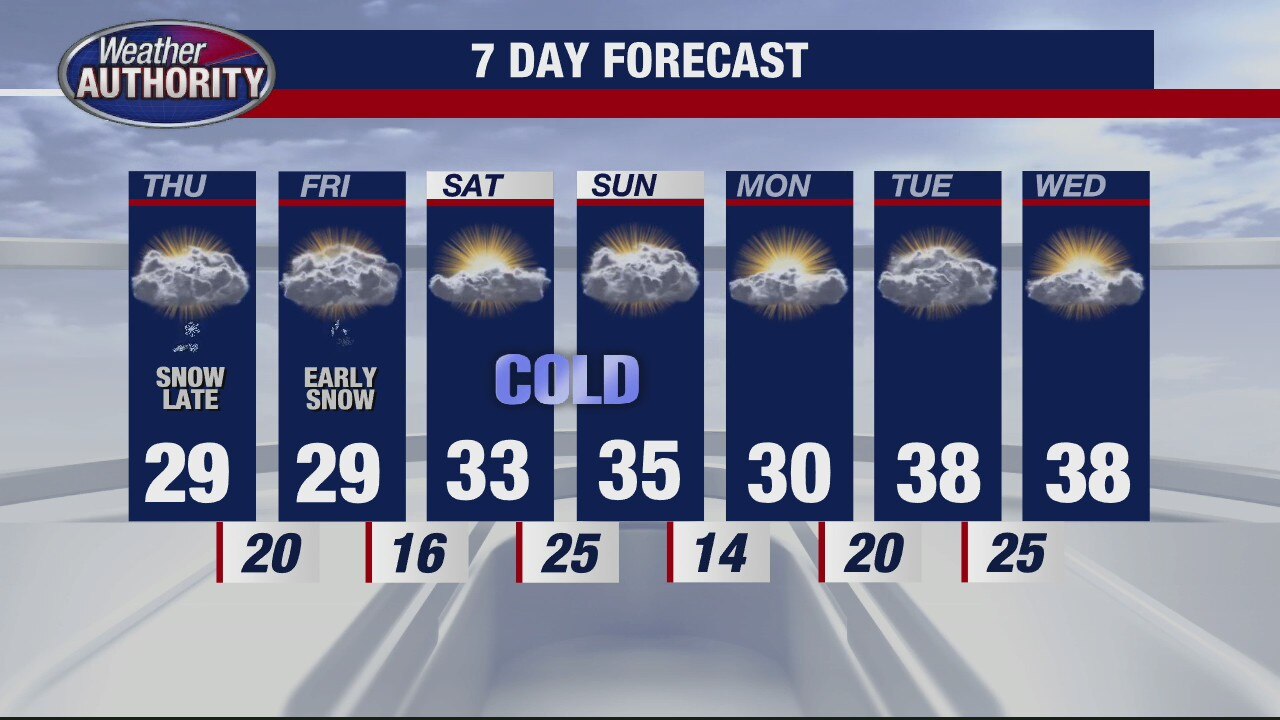
Get ready for another round of winter weather in Metro Detroit. Though most of Thursday look good under partly to mostly cloudy skies along with temperatures in the mid and upper 20s, snow showers are expected to move in after sunset. This snow will last through early Friday morning. 2 to 3"+ of snow is expected by the time everything is said and done. Roadways will be slick and slippery, so please take it easy first thing Friday morning.
Get ready for another round of winter weather in Metro Detroit. Though most of Thursday look good under partly to mostly cloudy skies along with temperatures in the mid and upper 20s, snow showers are expected to move in after sunset. This snow will last through early Friday morning. 2 to 3"+ of snow is expected by the time everything is said and done. Roadways will be slick and slippery, so please take it easy first thing Friday morning.
Chilly with some snow for Thursday
Rich Luterman has the forecast.
Rich Luterman has the forecast.

Cold winter temps have returned
Accumulating snow expected early Friday
Accumulating snow expected early Friday

Cold and Breezy Today
Though you'll notice a few flurries today along with cold and breezy air, more snow is on the way Thursday night into Friday morning. Generally speaking, 1 to 3 inches of snowfall is expected by midday Friday.
Though you'll notice a few flurries today along with cold and breezy air, more snow is on the way Thursday night into Friday morning. Generally speaking, 1 to 3 inches of snowfall is expected by midday Friday.

Cold air is moving in for rest of the week
Rich Luterman has the forecast.
Rich Luterman has the forecast.

Back to colder temps
Rich Luterman has the forecast.
Rich Luterman has the forecast.
Ice Up North but rain for us
Temps climb to nearly 55 degrees today.
Temps climb to nearly 55 degrees today.

Warmer - but very wet for Tuesday
Rich Luterman has the forecast.
Rich Luterman has the forecast.

A mild few days ahead
Temps climb all the way to 55 on Tuesday with some rain
Temps climb all the way to 55 on Tuesday with some rain