

Changes On The Way
Meteorologist Lori Pinson has your forecast
Meteorologist Lori Pinson has your forecast

Beautiful Weekend Ahead
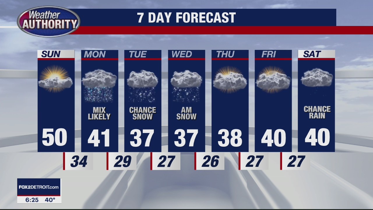
Get ready for a beautiful weekend ahead with lots of sunshine on Saturday. Highs should top out in the mid 40s today with a few more clouds rolling into Metro Detroit by Sunday evening. Accumulating snow is on the way by Monday, Tuesday and Wednesday.
Get ready for a beautiful weekend ahead with lots of sunshine on Saturday. Highs should top out in the mid 40s today with a few more clouds rolling into Metro Detroit by Sunday evening. Accumulating snow is on the way by Monday, Tuesday and Wednesday.

Dry Weekend Ahead
Meteorologist Lori Pinson has your forecast
Meteorologist Lori Pinson has your forecast

Mostly Cloudy Friday
Although we are expecting more clouds today, more sunshine is in our forecast this weekend. Enjoy it while it lasts because snow showers move back into Metro Detroit to start the next workweek.
Although we are expecting more clouds today, more sunshine is in our forecast this weekend. Enjoy it while it lasts because snow showers move back into Metro Detroit to start the next workweek.

Cloudy and Dry Thanksgiving
It's a dry turkey day if you are planning on being out and about today. After some of that patchy fog begins to burn off this morning, you will notice plenty of clouds during the day. Thankfully, those clouds are not expected to produce any more rain. Highs this afternoon should make it to around 50 degrees. Temperatures will fall into the upper 30s overnight. This will set the stage for a decent looking Friday and a beautiful weekend with lots of sunshine expected on Saturday with highs in the 40s.
It's a dry turkey day if you are planning on being out and about today. After some of that patchy fog begins to burn off this morning, you will notice plenty of clouds during the day. Thankfully, those clouds are not expected to produce any more rain. Highs this afternoon should make it to around 50 degrees. Temperatures will fall into the upper 30s overnight. This will set the stage for a decent looking Friday and a beautiful weekend with lots of sunshine expected on Saturday with highs in the 40s.

Detroit's Thanksgiving Day Forecast
Thankfully, we are expecting drier air in place in Metro Detroit on Thanksgiving Thursday. As for today, scattered rain is in our forecast from start to finish with the heaviest of the rainfall taking place in the afternoon. In total, we could pick up between 0.25" and 0.50" of rain by the time everything is said and done. High should make it into the mid 40s this afternoon which is right on par for this time of the year. After today, we should dry things out which will set the stage for a beautiful weekend ahead of us.
Thankfully, we are expecting drier air in place in Metro Detroit on Thanksgiving Thursday. As for today, scattered rain is in our forecast from start to finish with the heaviest of the rainfall taking place in the afternoon. In total, we could pick up between 0.25" and 0.50" of rain by the time everything is said and done. High should make it into the mid 40s this afternoon which is right on par for this time of the year. After today, we should dry things out which will set the stage for a beautiful weekend ahead of us.

Wet Wednesday weather fades by Thanksgiving!
Dry Thanksgiving with the potential for some snow early next week.
Dry Thanksgiving with the potential for some snow early next week.

Holiday Week Outlook
Meteorologist Lori Pinson has your forecast
Meteorologist Lori Pinson has your forecast

Light rain/snow showers break out Tuesday afternoon, wet weather wins on Wednesday.
But we're looking at a dry Thanksgiving Day!
But we're looking at a dry Thanksgiving Day!

Few flurries or sprinkles end early, more rain/snow arrives late Tuesday!
Wet weather wins out with our next system
Wet weather wins out with our next system

Weather update with Lori Pinson (11/22)
Weather update with Lori Pinson (11/22)
Weather update with Lori Pinson (11/22)

A Look INSIDE the Giant Uniroyal Tire in Allen Park, Michigan
FOX 2 News Weekend
FOX 2 News Weekend

Snowy Sunday in Metro Detroit
FOX 2 News Weekend
FOX 2 News Weekend
Rain/Snow Mix Expected Sunday
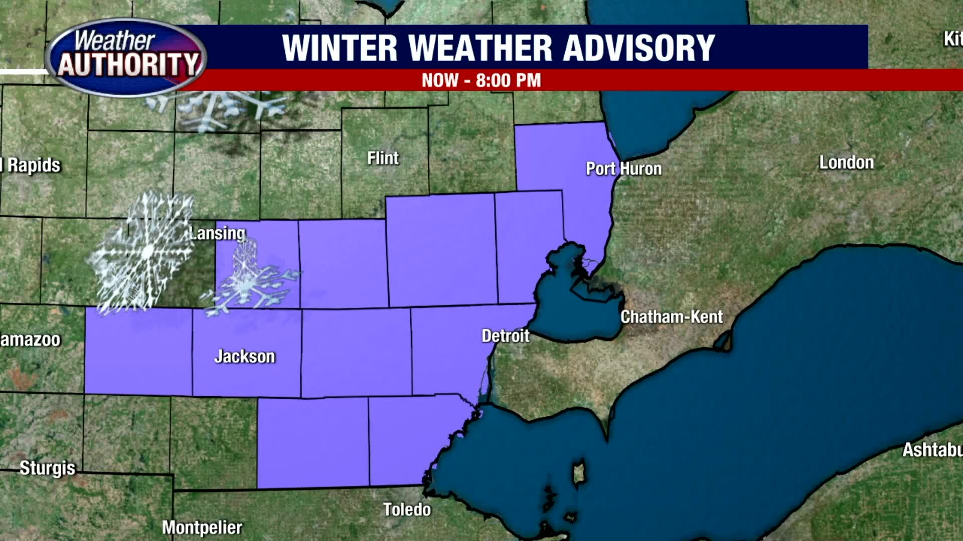
A rain and snow mix is expected on Sunday. A winter weather advisory is in effect this morning through this evening for all areas of Metro Detroit. Light snowfall accumulations are expected which could lead to slick and slippery spots on the roadways. Highs will only make it into the 30s.
A rain and snow mix is expected on Sunday. A winter weather advisory is in effect this morning through this evening for all areas of Metro Detroit. Light snowfall accumulations are expected which could lead to slick and slippery spots on the roadways. Highs will only make it into the 30s.

Rain Mix Possible on Sunday
Today looks good under partly sunny skies. Temperatures will be noticeably cooler with highs only in the mid 40s. Get your outdoor errands completed today because more rain and some snow showers are expected on Sunday. No big time accumulations are expected, but a few areas could pick up just under a half an inch of snow by the time everything is said and done on Sunday.
Today looks good under partly sunny skies. Temperatures will be noticeably cooler with highs only in the mid 40s. Get your outdoor errands completed today because more rain and some snow showers are expected on Sunday. No big time accumulations are expected, but a few areas could pick up just under a half an inch of snow by the time everything is said and done on Sunday.
Cold Front brings a chilly Saturday
Meteorologist Lori Pinson has your forecast
Meteorologist Lori Pinson has your forecast
Cold Front Chill Down
Meteorologist Lori Pinson has your forecast
Meteorologist Lori Pinson has your forecast

Colder Weekend
Meteorologist Lori Pinson has your forecast
Meteorologist Lori Pinson has your forecast

A warm finish to the week, with some rain and snow on the way for the weekend!
Another 60 degree day in SE Michigan!
Another 60 degree day in SE Michigan!

Unseasonably warm temps continue
Rich Luterman has the forecast.
Rich Luterman has the forecast.