

Detroit snow forecast: Early model shows significant snow in Southeast Michigan

Metro Detroit snow incoming, how much to expect
Southeast Michigan can expect to see a few inches of snow this week and more coming this weekend.
DETROIT (FOX 2) - With another five weeks before spring starts, Metro Detroit is bundled up and locked into winter. And this week, we're expecting some big snowfalls across Southeast Michigan.
The start of the week is typical for February: cold, sunny at times, cloudy, etc. You get it. But that's all about to change.
Wednesday, you're going to want to make sure the snowblowers are ready. You'll want to identify where that extra shovel is and the backup supply of ice after you get it all cleared.
Stay ahead of the weather with the FOX 2 Weather app. It's free on your phone and provides live radar, alerts, and more.
What to expect:
The snow will start pretty calm in Michigan around 2 p.m. on Wednesday – but it's going to pick up, making the drive home from work and school on Wednesday a slippery mess.
The snow is going to continue to fall throughout the afternoon, night, and Thursday morning. By the time it's all said and done, we could be looking at our highest snowfalls of the season for some of us.
The roads will be a mess that morning as you head to work and school, assuming there is school. If we get a lot of snow, expect a growing list of school closings.
How much snow in Metro Detroit?
One model is showing up to a foot of snow could fall in Lansing and Lapeer. But in reality, we're still too far away to know for sure.
That same model shows a little more than two inches of snow in Detroit, almost 6 inches in Pontiac, and just an inch in Monroe.
In other words, the heaviest bands are north and west of Detroit. But all of that could change. The heavy snow could slide in a different direction.
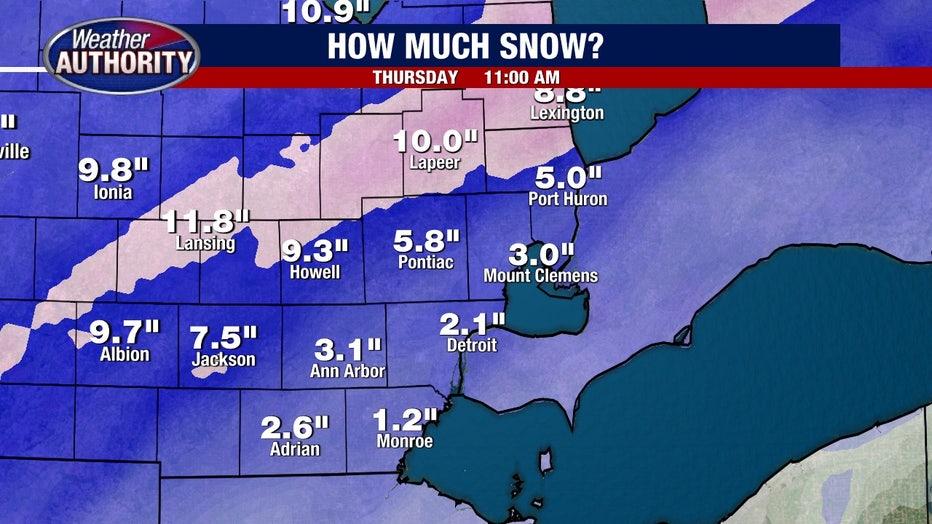
There's a band of freezing rain that could slide into Detroit. If it slides farther north, the lower the snow totals will be. But if it stays south of Michigan, we're looking at a decent snowmaker.
So, as of Monday at 11:30 a.m., more than 48 hours before the snow arrives, we're expecting at least 2 inches of snow and at most 10 inches. But the most likely result is between 3 and 6 inches of snow.
Where is the storm right now?
If you're looking to see what others are seeing with this system, you're out of luck. The storm isn't even dropping snow anywhere in the U.S.
The elements that are bringing the snow to Metro Detroit are still coming together over the Pacific Ocean.
The snow storm will be coming up from the southwest as it tracks over the Great Lakes.
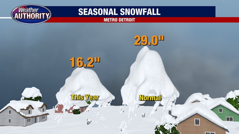
How much snow has Detroit seen this season?
Typically, by Feb. 10, we'll have close to 30 inches of snow for the season. But this year, we've had just 16.2 inches of snow.
Even if we were to get a decent amount, we still wouldn't catch up to where we normally are for this time of year.
Here's why that's tricky: those official measurements are all taken at Detroit Metro airport, meaning if the airport gets lower snow totals, the yearly average could be different from what you're seeing at your own home.
But don't fret – another snow system is moving in on Saturday, which could bring a decent amount as well. We won't go to deep into that one, yet. We'll stay focused on Wednesday and then update on Saturday's possible snow as we get closer.
The Source: FOX 2 Meteorologists Derek Kevra and Alan Longstreet.