

Metro Detroit Weather: Severe storms push in Tuesday night in Southeast Michigan

Strong storms move through the area, but the worst is over
Rich Luterman has an update on tonight's severe weather
DETROIT (FOX 2) - As if we have not had enough of the severe weather this summer, the season isn't over yet and, unfortunately, neither is our severe weather chance as we could see strong winds and even possibly a tornado Tuesday evening.
The following counties are all under a severe thunderstorm watch until 11 p.m.: Alcona, Allegan, Arenac, Barry, Bay, Berrien, Branch, Calhoun, Cass, Clinton, Eaton, Genesee, Gladwin, Gratiot, Hillsdale, Huron, Ingham, Ionia, Iosco, Isabella, Jackson, Kalamazoo, Kent, Lapeer, Lenawee, Livingston, Macomb, Midland, Monroe, Montcalm, Oakland, Ogemaw, Ottawa, Saginaw, Sanilac, Shiawassee, St. Clair, St. Joseph, Tuscola, Van Buren, Washtenaw, and Wayne.
The severe weather has left a number of power outages with DTE Energy reporting 39,000 outages as of 9:30 p.m. CLICK HERE to see the outage map.
If you were outside at any point Tuesday, you felt the heat and the humidity. It was MUGGY, like the middle of July muggy and temperatures hit almost 90. That's crazy! But that's all mixing together and a cold front is pushing in, bringing the potential for some severe weather targeting southeast Michigan.
The line of strong to severe storms is expected to develop between 4 and 01 p.m. on Tuesday with the first thunderstorms popping up in the northern part of the Thumb around 4 p.m.
The storms are then going to push to the southeast and may pop up supercells or multi-cells before becoming a broken line with possible bowing segments. That's when things could be dangerous as those could produce damaging winds and even possibly a tornado.

FOX 2 offers a mobile app dedicated to weather with an improved experience for all users.
The FOX 2 Weather app is available for free to all iPhone, iPad and Android users.
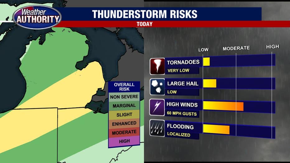
The biggest threat with this event is damaging winds which could hit 60 mph. That means power outages.
There's also the concern of large hail - up to an inch in diameter - and isolated flash flooding. Given the setup of this storm, the concern of tornadoes isn't out of the question. While it's not terribly high, it's not zero either.
By 10 p.m., this system should have pushed southeast out of the Detroit area.
Once we wake up on Wednesday, the weather will be much cooler with nothing more than a spotty shower.