

Michigan Congressional Districts - what to know about the new electoral map for 2022 elections
(FOX 2) - The 2022 Midterm elections this August and November will be the first that Michigan voters cast their ballots in the state's newly drawn districts.
The boundaries drawn for Michigan's Congressional races, as well as state senate and representative races will be the first created using a new nonpartisan redistricting committee tasked with organizing districts.
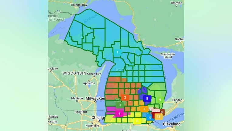
The first difference in Michigan's new Congressional map is that it has one less district. That's because the state's population growth didn't keep pace with other states, leading to only 13 seats in Congress. Here's where they are and the cities and counties that make up each district.
Read more 2022 midterm election coverage here.
Southeast Michigan Congressional Districts
District 13
The 13th District is made up of 775,674 people and encompasses the eastern half of Detroit and the middle portion of Wayne County.
The cities also included in the district include Melvindale, River Rouge, Lincoln Park, Allen Park, Wyandotte, Taylor, Wayne, Southgate, and Romulus.
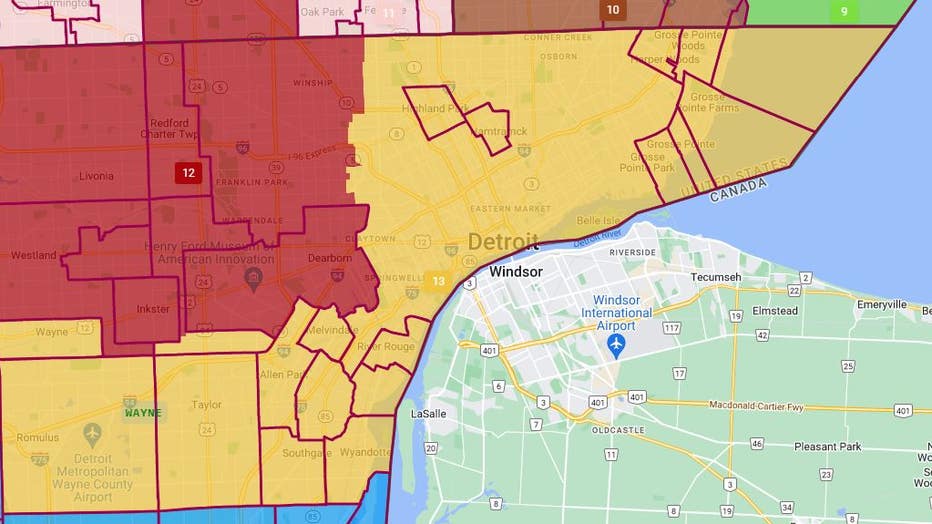
District 13 (Yellow)
District 12
The 12th District has 775,234 people in it and includes the western side of Detroit and parts of Wayne County, as well as a portion of Oakland County.
The cities include Detroit, Redford, Livonia, Dearborn, Dearborn Heights, Inkster, Westland, and Garden City in Wayne County. It also includes Southfield in Oakland County.
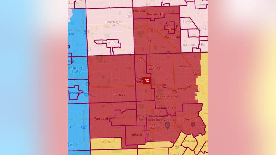
District 12 (Red)
District 11
The 11th District has 775,481 people in it and includes communities in southern Oakland County.
The cities include Farmington Hills, Farmington, Wixom, Walled Lake, Commerce Township, Waterford, Bloomfield, West Bloomfield, Bloomfield Township, Bloomfield Hills, Pontiac, White Lake, Auburn Hills, Clawson, Birmingham, Troy, Royal Oak, Oak Park, Berkley, Pleasant Ridge, Ferndale, Hazel Park, Madison Heights, and Hunting Woods.
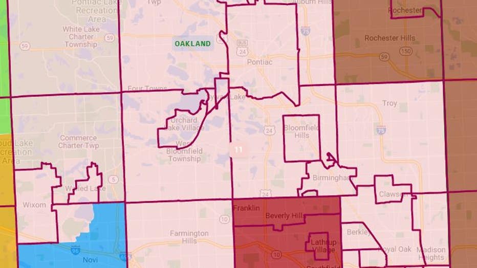
District 11 (Light Pink)
District 10
The 10th District has 775,218 people in it and includes southern Macomb County and a portion of Oakland County.
The cities in Macomb County include Warren, Center Line, Eastpointe, St. Clair Shores, Roseville, Fraser, Clinton Township, Mt Clemens, Harrison Township, Sterling Heights, Utica, and Shelby Township. In Oakland County, it includes Rochester and Rochester Hills.
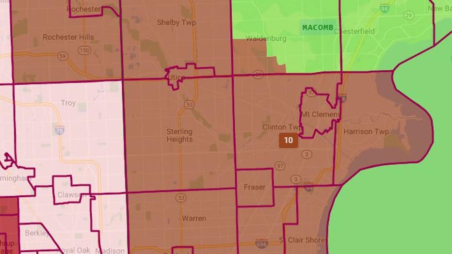
District 10 (Brown)
Lower Peninsula Michigan Congressional Districts
District 9
The 9th District has 776,555 people in it and includes most of the thumb of Michigan.
That includes portion of Macomb and Oakland counties, as well as Lapeer, St. Clair, Sanilac, Tuscola, and Huron counties.
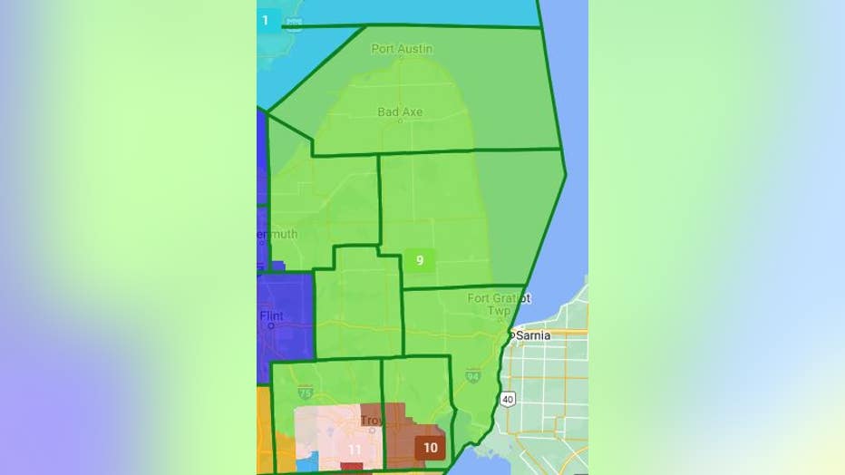
District 9 (Green)
District 8
The 8th District has 773,019 people in it and includes Genessee, Saginaw, Bay, and a portion of Midland counties.
The district includes cities like Grand Blanc, Flint, Saginaw, and Midland.
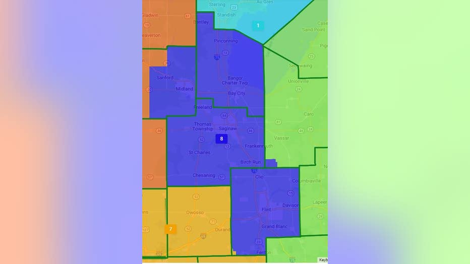
District 8 (Blue)
District 7
The 7th District has 775,373 people in it and includes much of mid-Michigan, stretching from the western edge of Oakland County to Eaton County.
Some larger cities include Brighton, Howell, Lansing, St. Johns, and Eaton Rapids.
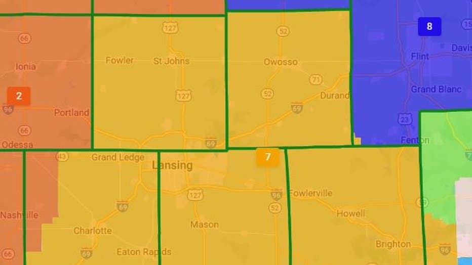
District 7 (Light Orange)
District 6
The 6th District has 776,619 people in it and stretches from the western edge of Lake Erie in southern Wayne County as well as portions of Oakland County and all of Washtenaw County.
The cities include Canton, Plymouth, Belleville, and Brownstown Charter Township in Wayne County, Novi in Oakland County, and Ann Arbor, Ypsilanti, Saline, Pittsfield Charter Township, Manchester, and Chelsea.
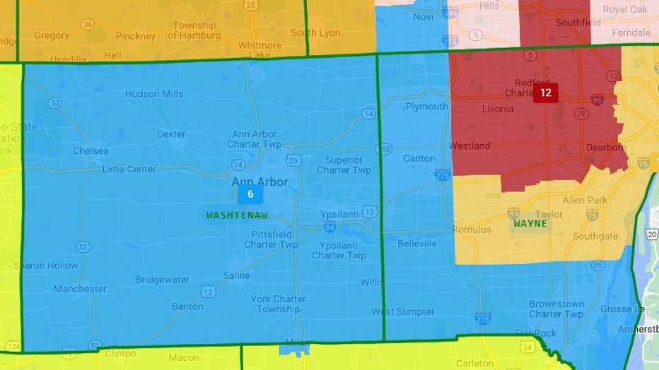
District 6 (Light Blue)
District 5
The 5th District has 771,861 people in it and stretches the entire length of the lower portion of the state of Michigan.
The district includes every county from Lake Erie to Lake Michigan along the southern border. That includes Monroe, Lenawee, Hillsdale, Branch, St. Joseph, Cass, and Berrien counties.
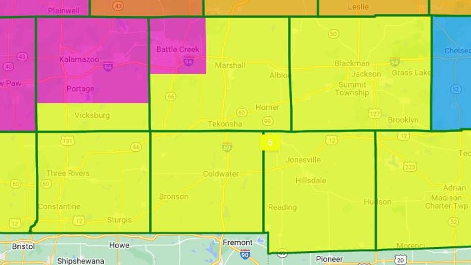
District 5 (Yellow)
District 4
The 4th District has 776,506 people and includes the western side of Michigan. It stretches from Benton Harbor to Holland and the southwest border of Grand Rapids.
The biggest cities include Kalamazoo, Portage, Battle Creek, and many coastal towns like South Haven and Saugatuck.
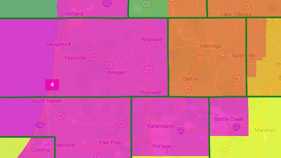
District 4 (Pink)
District 3
The 3rd District has 783,320 people in it and includes primarily west Michigan communities. That includes the entirety of Grand Rapids and surrounding communities.
Also included is Muskegon, Grand Haven, and the southern portion of Muskegon County.
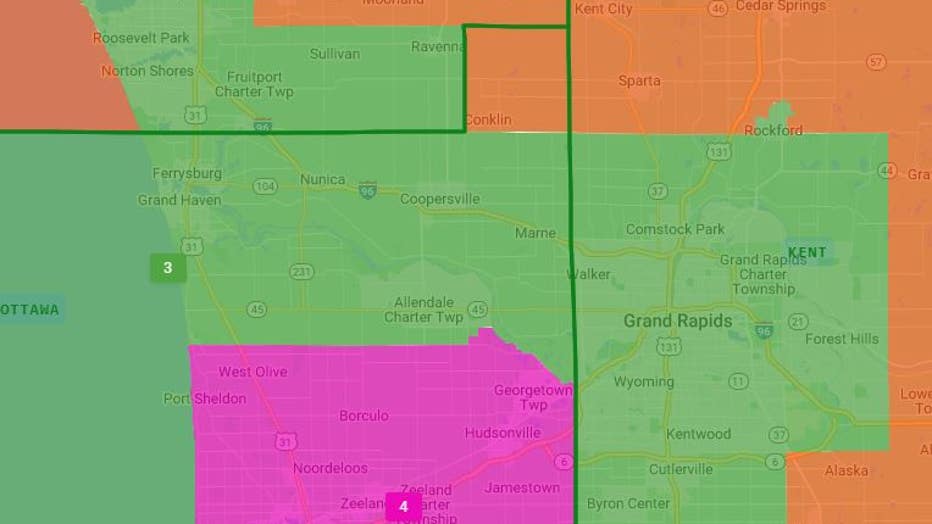
District 3 (Dark Green)
Northern Michigan Congressional Districts
District 2
The 2nd District has 766,784 people in it and includes a large portion of the lower peninsula's top half. It includes people in 18 counties, stretching from Barry County to Manistee and Wexford, where Cadillac is located.
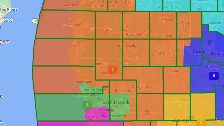
District 2 (Orange)
District 1
The 1st District has 775,684 people in it and has the largest portion of land of any district in the state. It includes the entire Upper Peninsula and 21 counties in the lower peninsula.
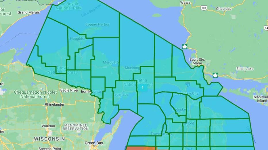
District 1 (Teal)