Fall moves in this week in Southeast Michigan with occasional rain chances and a drop in temperatures

Mid Week Chill Down
Scattered showers overnight give way to sun & clouds Monday. Much cooler temperatures by mid week. Meteorologist Lori Pinson has your forecast.
(FOX 2) - A cluster of storms is rolling through Southeast Michigan this morning with heavy rain and small hail possible through mainly the first part of the morning commute.
Those storms should wind down between 6-8 a.m. and the rest of the day remains dry.

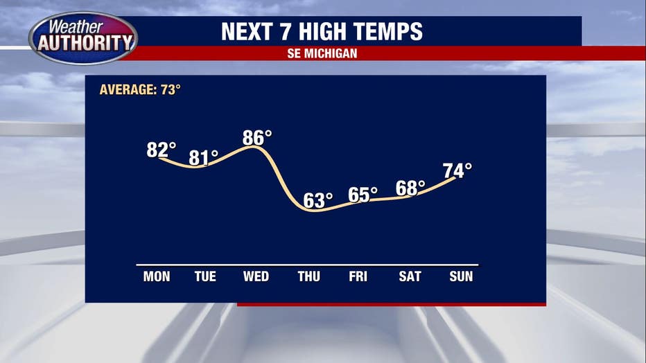
The morning storms are ahead of a cold front that slips through and lowers our humidity. Temperatures however stay above average until a late week cold front swings in at some point Wednesday.

If that front holds off until late Wednesday severe weather can't be ruled out. We're sitting under a marginal and slight risk, so isolated to widely scattered strong storms are possible, though I'd hesitate to call them likely at this point.

Behind the Wednesday front, temperatures plummet. The highs in the 60s and lows in the 40s by Friday morning, something we haven't felt since May.