

Metro Detroit school closings: Will cold weather lead to canceled classes Wednesday?

Tips for staying safe during dangerous cold
Temperatures in Metro Detroit are not only bitter, they're dangerous. Hypothermia and frostbite are just two conditions that can set in quickly when temperatures are so low.
DETROIT (FOX 2) - Metro Detroit woke up to another extremely cold start to the day as wind chills hovered near 10 below zero. But get ready, because Wednesday morning might be even worse.
READ: When the bitter cold stretch will end
Let's start with today. High temperatures will make it to 11 degrees but with a 20 mile an hour southwest wind. Plan on the wind chill to be close to -5. We are once again looking at a day where the wind chills will be below zero all day long.
The light snow from the morning will taper off, but the roads remain slick as the salt has a hard time working well with temperatures this cold. If you're hitting the road to go anywhere today, take it easy.

Metro Detroit road conditions: How driving is looking Tuesday morning
How are the roads? Here's a look at road conditions and the live traffic map in Southeast Michigan.
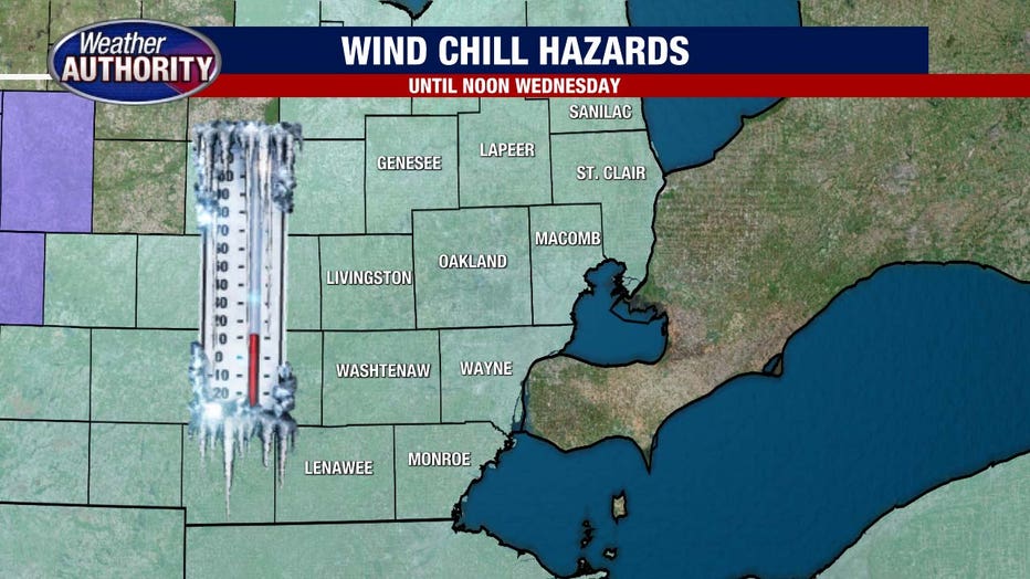
Tuesday night we will fall to 0° as the winds pick up to 25 mph. This creates a dangerously cold Tuesday night/Wednesday morning situation as a wind chill advisory kicks in. Wind chills will be as low as 20° below zero!
Track the weather wherever you are with the FOX 2 Weather App. It's completely free and shows live radar, temperatures, incoming weather, and so much more. It also works anywhere in the world! Wherever you go, take the FOX 2 Weather App with you.
The Wind Chill Advisory starts at 7 p.m. Tuesday for Wayne, Oakland, Macomb, Washtenaw, Monroe, St. Clair, Livingston, and Lapeer counties. It will be in effect until noon on Wednesday.
Tuesday, wind chills in the morning were in the negative single digits to about -10, depending on the area.
Hundreds of schools were closed due to Tuesday's cold, and more could also cancel classes Wednesday because of even more hazardous weather.
VIEW: School closings list
In temperatures as cold as this, it can take less than 20 minutes for frostbite to set in. Be very careful if you are outside or if you have pets that are outside.

Temperatures by Wednesday afternoon rise to the upper teens, and while cold it is an improvement. Wind chill values will be near five.
Long-term, we have to get through this weekend before we break that freezing barrier. Next week looks milder as high temperatures return to the mid-30s.
Bundle up and be careful!