

Metro Detroit snowfall continues with several inches, warmer temperatures into weekend

Continued snowfall in metro Detroit could make slippery conditions
It's another winter weather day in metro Detroit with several inches of snow expected Thursday and Friday, primarily in the mornings.
(FOX 2) - The frigid temperatures appear to be living over metro Detroit during this round of winter weather - however, more snowfall is expected over the next two days heading into the weekend.
Most commuters will awake to a fresh round of snow that's expected to fall over Southeast Michigan Thursday morning. Light precipitation will continue through the early hours before tapering off closer to noon. The bulk of snowfall totals will be found along I-69 and M-59, reaching two inches.
The snow is wet, so be extra careful on the roads, which could see conditions get slippery.
Luckily, temperatures will rebound back up to 26 degrees by midday Thursday. It won't be enough to melt any snow, but plan on some of relief from the cold.
Friday will offer more of the same, with snowfall expected to continue in the morning before tapering off in the afternoon.
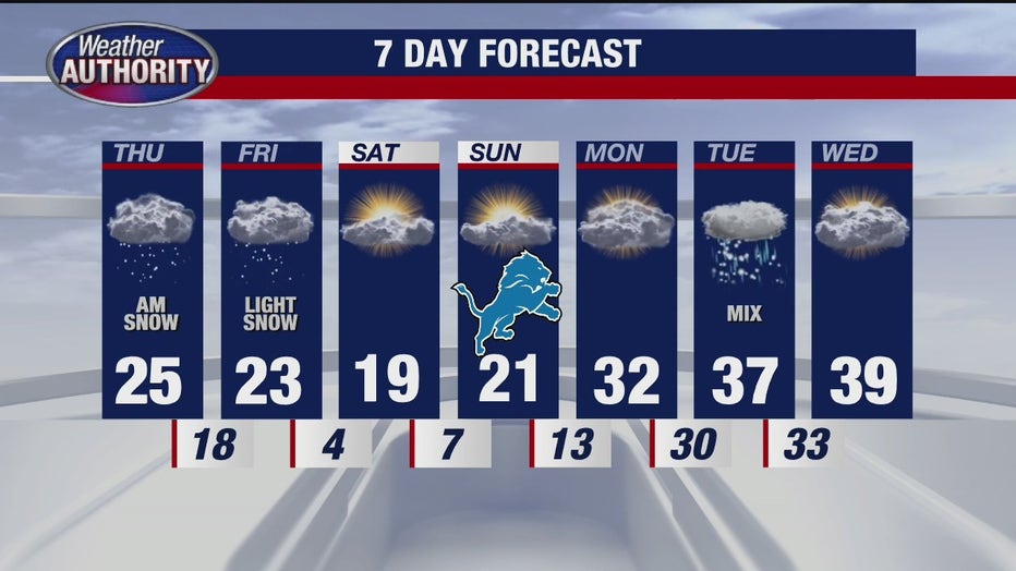
The National Weather Service is expecting up to 3 inches of snow in the heaviest hit places, partly because of lake effect snow. Temperatures will again hit the mid-20s.
MORE: Accidents, mechanical issues hinder plow trucks in Bloomfield Township during storm
It is expected to rebound back up near 40 degrees next week, which means all that snow that has fallen over the past week will likely disappear by then.