Metro Detroit Weather: Winter storm lurks for Michigan this week

Wednesday and Thursday Winter Storm System
We'll see rain, sleet, freezing rain and snow as temps plummet.
SOUTHFIELD, Mich. (FOX 2) - Tuesday's sunny but cold weather will lead to a transitional period on Wednesday with rain, then sleet, and snow all coming over the next few days. But how much snow we'll see here in Detroit is still up in the air.
First, though, let's about the warm-up. Temperatures will rise overnight to the upper 40s on Wednesday, more than 10 degrees above the norm as a warm front moves north across the state. This will also increase clouds and bring rain to the area by Wednesday afternoon, which will be heavy at times and a gusty wind will blow in from the south and we'll stay mild with overnight lows around 40 degrees.
Michigan snow: How does snow form and where did it come from?
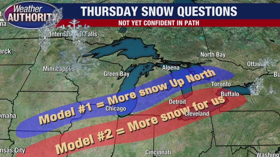
What happens next, however, is still a bit up on the air and there are two different projections as the second component to our winter storm sets up.
Thursday will be one of those days when our high temperature will happen after midnight and fall all day long.
A cold front will push in, bringing a sharp change in wind direction as it moves across Michigan. This will switch our south wind to a more northerly one, ushering in colder air. All this is happening while there is still moisture in the area.
Want to get the latest news and weather updates from your phone instantly? Download the FOX 2 app today on Android and iPhone today. You can also sign up for our FOX 2 newsletters to have breaking news delivered to your email. Sign up here to have them sent to you.
VIEW: School closings
So our rain will transition to snow late Thursday. And that's the challenge of this forecast. How long will the warm air stay in place?
One model suggests the mild air will linger and take longer to transition to colder air. In that scenario, our accumulating snowfall totals would occur farther north. For example, Howell could receive close to four inches, while Detroit and closer suburbs would be in the one to two inch range.
Before the rain, sleet, and then snow even start, you NEED the FOX 2 Weather app. It's 100% free and gives you live radar, projections, and the alerts that are the most important for your day.
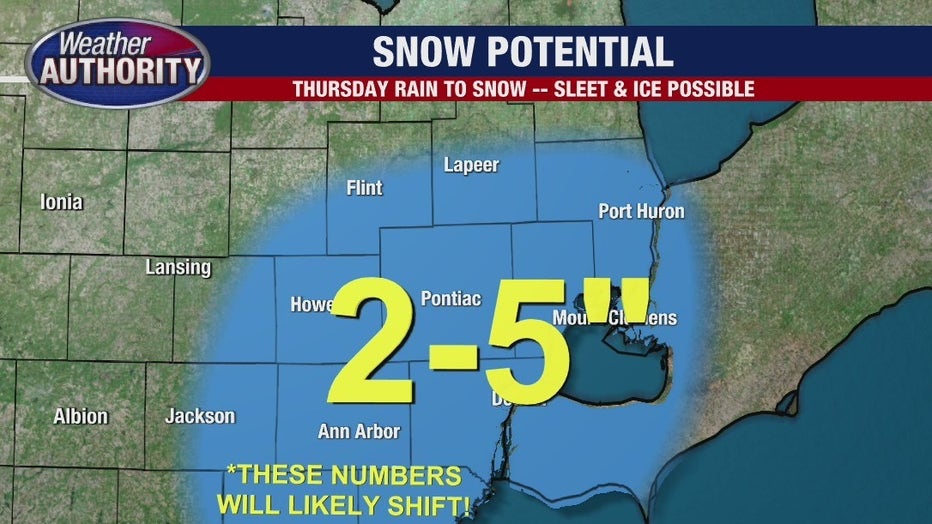
Option number two would bring heavier snow totals to the city. This occurs if the transition time from warm to cold air is faster. That weather model suggests a general two to five inches of snow on Thursday with perhaps lingering snow Friday on the back side of the low pressure system moving through the state.
Through both models though, windy conditions won't stop.
More: How to drive in a snowstorm
Whatever falls and for however long a duration, Thursday night/Friday morning temperatures suggest widespread icing with overnight lows near 10 degrees and wind chill values (because of the persistent gusty wind) in the single digits.
A brief period of snow is also forecasted for Saturday morning, still breezy, with highs before the wind chill near 27 degrees.
Winter storm warning: How to deal with frozen pipes
Fortunately, by Sunday the temperatures turn around again, with highs in the 40s.
Keep it right here for more weather updates and download our Fox2 Weather App for the latest changes in your area.