

Michigan severe weather: 75 mph winds, hail, and tornado potential may strike region Monday night

(FOX 2) - There is a legitimate chance that we could be seeing some severe weather today in Southeast Michigan, and if it travels in our direction you'll need to be prepared.
A weather system called a Mesoscale Convective System (MCS for short) is expected to gain strength over the next six hours and could impact some locations after 8 p.m. Monday evening.
The system is gaining instability and energy as it travels from Minnesota and into Wisconsin. By 5 p.m. it will begin to travel over Lake Michigan, where it may lose a little organization, which it will regather by the time it starts over Western Michigan.
Monday evening near 9 p.m., it'll start diving QUICKLY through the state, getting larger and more well organized. All indications are that we will see the storms between 10 p.m. and 2 a.m. this morning, with then lingering storms passing over us all night long.
The biggest concern with this storm - the MCS - is that as it moves at 40 mph, portions of the storm could begin to bow. This typically aligns with even stronger winds, meaning we could see the gusts up to 75 mph. If any of the upper winds aloft start to descend to the surface we could see an isolated tornado develop.
Additionally, large hail is a possibility with diameters possibly reaching 1 inch.
RELATED: Heavy storm potential tonight, extreme heat Wednesday
Rounds of heavy rain could trail the system overnight, and this could lead to some isolated flooding. Rainfall totals may exceed 1.5 inches.
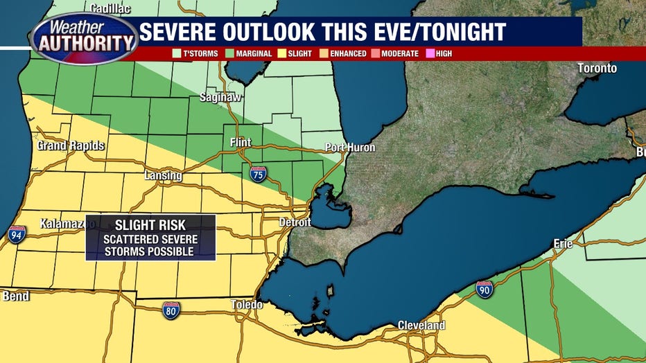
As of now, the storm track looks to dive through South central Michigan, BUT I fear that Washtenaw, Wayne, Lenawee and Monroe Counties are all at risk of seeing some of this severe weather.
Other counties are not immune, but as of now look to remain slightly out of the path of the worst of it.
RELATED: Flooding victims could find disaster relief from one of these 26 programs
Mesoscale Convective Systems have some uncertainty involved with them, in terms of where and how they develop. It is possible that the strongest storms may dive through Southwest and Southcentral Michigan and we may be on the outside looking in.
But to me, the threat and the risk are there, and I think some severe weather will impact us this evening and tonight.