

Southeast Michigan's rainy weather stretch comes to a close - and so does the humidity

One more day with rain, then we're good to go for the weekend!
Isolated to scattered showers/storms develop midday.
DETROIT - Our rainy stretch of weather is coming to a close!
Isolated to scattered showers should pop up midday into the afternoon with a stray rumble of thunder possible which means most of the day will be dry. We won't all see the rain and what rain we do see will be less than days past.
Speaking of moisture! Our humidity has been through the roof, but with the wind shifting to the north drier and cooler air will spill into Southeast Michigan.
Humidity levels will drop over the course of today and high temps today and tomorrow don't hit 80 with overnight lows falling into the 50s.
Rain chances look limited all the way through the weekend.
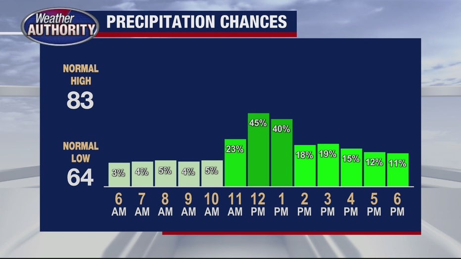
Isolated to scattered showers should pop up midday into the afternoon with a stray rumble of thunder possible which means most of the day will be dry
I'll keep Friday, Saturday, and Sunday dry with partly to mostly sunny skies and the heat turning back up by the 4th of July with high temps set to make a run to 90°.
Looking toward next week
Hot weather likely sticks around through the first part of the week without any major systems showing up in the data, but a cold front may bring a shower or storm by Tuesday.