


Some Tuesday morning showers with lower humidity on the way!
It will be windy and less humid this afternoon.
It will be windy and less humid this afternoon.

Storms expected early Tuesday
Rich Luterman has the forecast.
Rich Luterman has the forecast.

Chance for storms Tuesday
Rich Luterman has the forecast
Rich Luterman has the forecast

Spotty Showers Monday
Do not forget your umbrella this morning. We are tracking a few spotty showers across Metro Detroit to get your Monday started. Through the afternoon, though an isolated shower is possible, we will start to dry things out. Highs today should jump into the mid 80s this afternoon with lots of humidity. Scattered showers and thunderstorms are expected Tuesday morning as a cold front moves through. No severe weather is expected at this time. Cooler air is on the way by midweek.
Do not forget your umbrella this morning. We are tracking a few spotty showers across Metro Detroit to get your Monday started. Through the afternoon, though an isolated shower is possible, we will start to dry things out. Highs today should jump into the mid 80s this afternoon with lots of humidity. Scattered showers and thunderstorms are expected Tuesday morning as a cold front moves through. No severe weather is expected at this time. Cooler air is on the way by midweek.

Father's Day Sunday Forecast
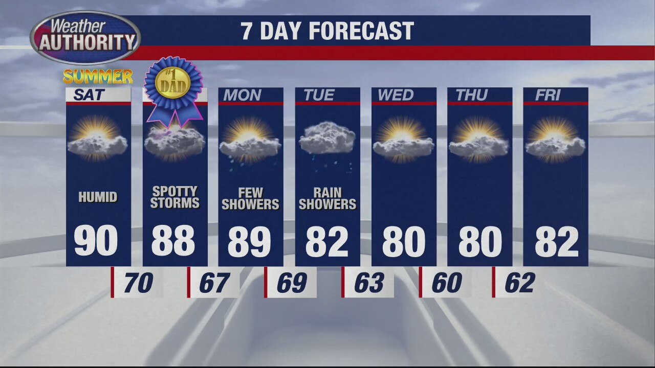
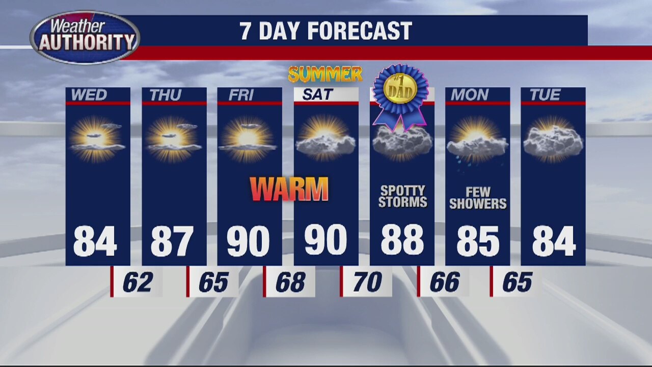
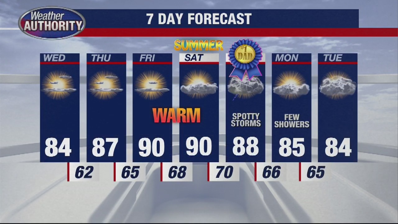
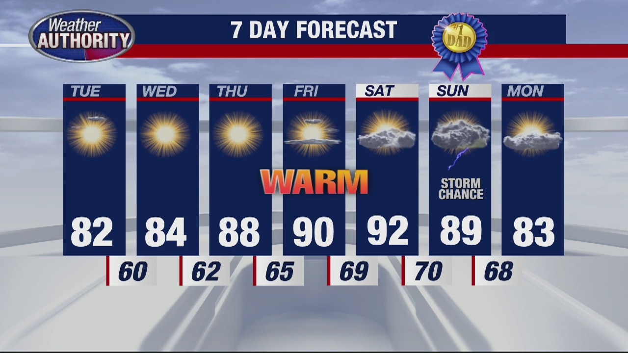
If you're heading out with dad today, be on the lookout for a few spotty showers and thunderstorms. The morning looks great, but it is into this afternoon with the passage of a weak cold front that may trigger some rain and storms. Thankfully, no severe weather is expected. Highs should make it into the upper 80s today with a light southwest breeze.
If you're heading out with dad today, be on the lookout for a few spotty showers and thunderstorms. The morning looks great, but it is into this afternoon with the passage of a weak cold front that may trigger some rain and storms. Thankfully, no severe weather is expected. Highs should make it into the upper 80s today with a light southwest breeze.

Sizzling Saturday
After a mild start this morning, we are expecting temperatures to soar into the low 90s this afternoon under partly sunny skies. You will feel the humidity later this afternoon which will make it even even warmer than the actual temperature this afternoon. Make sure you are staying well hydrated. Your Father's Day Sunday morning looks good, but showers and a few thunderstorms are possible during the afternoon.
After a mild start this morning, we are expecting temperatures to soar into the low 90s this afternoon under partly sunny skies. You will feel the humidity later this afternoon which will make it even even warmer than the actual temperature this afternoon. Make sure you are staying well hydrated. Your Father's Day Sunday morning looks good, but showers and a few thunderstorms are possible during the afternoon.
Chance of storms for Father's Day
Rich Luterman has the forecast.
Rich Luterman has the forecast.
Hot and Humid Weekend Ahead
If you are heading out and about today, make sure you are staying well hydrated. It is going to be very warm with highs today jumping into the upper 80s to near 90 degrees this Friday afternoon. Skies should remain partly to mostly sunny with an isolated shower possible. Thankfully, most areas should stay nice and dry. More heat and humidity are on the way Saturday and Sunday with temperatures in the low 90s. If this is too warm for you, not to worry, a cool down is on the way by the end of next week.
If you are heading out and about today, make sure you are staying well hydrated. It is going to be very warm with highs today jumping into the upper 80s to near 90 degrees this Friday afternoon. Skies should remain partly to mostly sunny with an isolated shower possible. Thankfully, most areas should stay nice and dry. More heat and humidity are on the way Saturday and Sunday with temperatures in the low 90s. If this is too warm for you, not to worry, a cool down is on the way by the end of next week.
Sweet weather again to finish the week, temps near 90? through the weekend!
A spotty shower is possible this afternoon.
A spotty shower is possible this afternoon.

Sunny and warm pattern continues
Rich Luterman has the forecast.
Rich Luterman has the forecast.
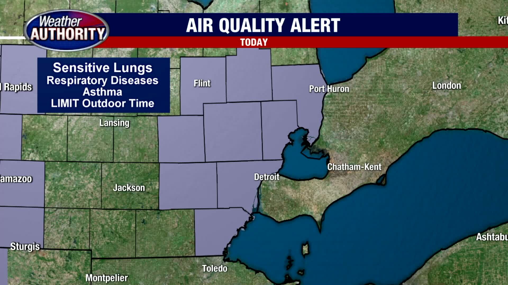
Air Quality Alert Thursday. We're heading toward 90? by the weekend!
A spotty shower chance on Friday with a better bet for some wet weather over the weekend.
A spotty shower chance on Friday with a better bet for some wet weather over the weekend.

Still sunny and warm
Rich Luterman has the winning forecast.
Rich Luterman has the winning forecast.

Weather perfection continues another day with some changes lurking late week/weekend.
80's with sun today near 90 Friday/Saturday.
80's with sun today near 90 Friday/Saturday.
Warming trend continues through the week
Rich Luterman has the forecast.
Rich Luterman has the forecast.
Great stretch of weather continues as temps get warmer
Rich Luterman has the forecast.
Rich Luterman has the forecast.

Another Beautiful Day
Warm and sunny week continues
Warm and sunny week continues
Tuesday weather is taking a bit of a turn... Temps are heading up!
Low 80's today, 90? by the end of the week.
Low 80's today, 90? by the end of the week.
Temps warm up by weekend
Rich Luterman has the forecast.
Rich Luterman has the forecast.

A chilly Monday morning with a warm up coming!
Temps make a run for 90 by the weekend.
Temps make a run for 90 by the weekend.
Cool and Breezy Sunday
Although it is a cool start this Sunday morning with temperatures in the 40s and 50s, with more sunshine this afternoon, we will warm things up into the low 70s under mostly sunny skies. Thankfully, that sunshine should last all day long with a northeast breeze between 5 to 15 mph gusting at times up to 30 mph. If you are heading out on Lake St. Clair, we are expecting 1 to 2 foot waves on the water, so it could be a little choppy at times. Otherwise, look for temperatures to fall into the low 50s overnight. This upcoming workweek looks great with highs eventually jumping into the 80s by Tuesday, Wednesday and Thursday before topping out around 90 by Friday.
Although it is a cool start this Sunday morning with temperatures in the 40s and 50s, with more sunshine this afternoon, we will warm things up into the low 70s under mostly sunny skies. Thankfully, that sunshine should last all day long with a northeast breeze between 5 to 15 mph gusting at times up to 30 mph. If you are heading out on Lake St. Clair, we are expecting 1 to 2 foot waves on the water, so it could be a little choppy at times. Otherwise, look for temperatures to fall into the low 50s overnight. This upcoming workweek looks great with highs eventually jumping into the 80s by Tuesday, Wednesday and Thursday before topping out around 90 by Friday.