


Meet Smores!
FOX 2 News Weekend
FOX 2 News Weekend

Meet Gracie aka Pooches!
FOX 2 News Weekend
FOX 2 News Weekend

Much Colder Saturday
We are noticeably cooler today than we were yesterday. Highs will only make it into the mid and upper 40s. We made it close to 80 degrees on Friday. This cooler pattern will settle in not only today, but also tomorrow and into next workweek.
We are noticeably cooler today than we were yesterday. Highs will only make it into the mid and upper 40s. We made it close to 80 degrees on Friday. This cooler pattern will settle in not only today, but also tomorrow and into next workweek.
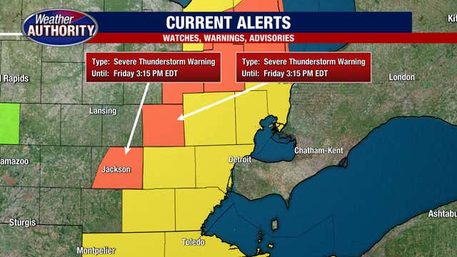

Severe thunderstorm watch in effect Friday afternoon for all of southeast Michigan
A severe thunderstorm watch is in effect for all of southeast Michigan until 9 p.m. Friday.
A severe thunderstorm watch is in effect for all of southeast Michigan until 9 p.m. Friday.

Afternoon Rain and Storms
The first half of Friday looks great! Enjoy the sunshine and warm temperatures. Highs should top out in the mid 70s this afternoon. With the approach of a cold front, showers and thunderstorms are expected mainly between 3pm to 8pm. Damaging winds is our primary threat with hail, lightning and ponding on the roadways possible as well. Temperatures will crash after the cold front and storms move through with lows falling into the 30s. Temperatures on Saturday are only forecast in the 40s.
The first half of Friday looks great! Enjoy the sunshine and warm temperatures. Highs should top out in the mid 70s this afternoon. With the approach of a cold front, showers and thunderstorms are expected mainly between 3pm to 8pm. Damaging winds is our primary threat with hail, lightning and ponding on the roadways possible as well. Temperatures will crash after the cold front and storms move through with lows falling into the 30s. Temperatures on Saturday are only forecast in the 40s.

Warmer and stormy Friday!
Severe storms are possible this afternoon.
Severe storms are possible this afternoon.

Morning Showers Again
But the afternoon will dry out and begin to warm up
But the afternoon will dry out and begin to warm up

Thursday morning rain may be heavy at times, drying this afternoon.
Temps still set to make a run for 70 Friday.
Temps still set to make a run for 70 Friday.

Early rain for Thursday
Rich Luterman has the forecast.
Rich Luterman has the forecast.

Wednesday showers fade early, sun comes back later.
Temps near 60 with a wind kicking up this morning.
Temps near 60 with a wind kicking up this morning.


NASA mission touches down on asteroid Bennu: Here’s what you need to know
After orbiting the near-Earth asteroid Bennu for nearly two years, NASA’s OSIRIS-REx spacecraft collected a sample from its surface on Tuesday.
After orbiting the near-Earth asteroid Bennu for nearly two years, NASA’s OSIRIS-REx spacecraft collected a sample from its surface on Tuesday.

Chance of rain rest of week
Rich Luterman has the forecast.
Rich Luterman has the forecast.
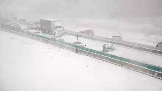

Winter weather brings 'multiple' rounds of snow to Upper Midwest, Iowa hit with snow squalls
Several weather systems will spread snow from the Northern Rockies through the Northern Plains and Upper Midwest this week.
Several weather systems will spread snow from the Northern Rockies through the Northern Plains and Upper Midwest this week.

Tuesday temps moving up a touch. Rain stays away for the day.
Rain showers return tonight, late week warm up is still on tap.
Rain showers return tonight, late week warm up is still on tap.

Still chilly for Tuesday
Rich Luterman has the forecast
Rich Luterman has the forecast

A chilly Monday with some rain followed by a late week warm up!
Near 70 by week's end.
Near 70 by week's end.

Meet Noah!
FOX 2 News Weekend
FOX 2 News Weekend

Cloudy, Cool and Wet Sunday
Grab your umbrellas if you plan on being out and about today. Periods of rain are expected not only this morning, but more so through this afternoon and evening as a cold front moves through Metro Detroit. We are only expecting between 0.10 and 0.25 inches of rain. Highs will struggle to make it into the upper 50s. We should fall to around 40 degrees overnight. By mid to late week, though warmer air is on the way, showers and perhaps a few thunderstorms will also work their way into the picture.
Grab your umbrellas if you plan on being out and about today. Periods of rain are expected not only this morning, but more so through this afternoon and evening as a cold front moves through Metro Detroit. We are only expecting between 0.10 and 0.25 inches of rain. Highs will struggle to make it into the upper 50s. We should fall to around 40 degrees overnight. By mid to late week, though warmer air is on the way, showers and perhaps a few thunderstorms will also work their way into the picture.

Showers Sunday
Meteorologist Lori Pinson has your forecast
Meteorologist Lori Pinson has your forecast
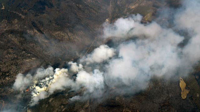

Strong winds fan Cameron Peak wildfire, largest in Colorado's history
The largest wildfire in Colorado history grew overnight as high winds pushed the blaze through rural communities and the forecast predicts more “extreme fire behavior” on Saturday.
The largest wildfire in Colorado history grew overnight as high winds pushed the blaze through rural communities and the forecast predicts more “extreme fire behavior” on Saturday.