

Metro Detroit Weather: Snowstorm totals down on Thursday, still expect 8 to 12 inches

Metro Detroit likely to see a foot of snow Wednesday and Thursday
A massive winter storm spanning almost the entire midwest and much of the northeast is here and we expect to get about a foot of snow over two days.
DETROIT (FOX 2) - A major winter storm is still expected to bury southeast Michigan in snow, although new model data coming in has shifted the forecast a bit and we are looking at a little less snow than originally expected.
That all being said, we're still going to get a LOT of snow and a winter storm warning has been issued for all of southeast Michigan.
Want to get the latest news and weather updates from your phone instantly? Download the FOX 2 app today on Android and iPhone today. You can also sign up for our FOX 2 newsletters to have breaking news delivered to your email. Sign up here to have them sent to you.
How long will it snow in Metro Detroit?
The timing of the snow will end much earlier than previously expected due to a southern shift in Thursday's storm track.
This means that the majority of our accumulating snow will happen on Wednesday, with a few more inches expected Thursday.
MORE: 7 creative winter activities besides snowball fights that everyone will love
Overall this shifts our higher end totals DOWN a bit from what was first expected earlier this week.
Tuesday evening/night rain showers will transition into snowflakes between 3-4AM early Wednesday morning.
The city of Detroit will give an update at 3 p.m. on its plan to keep the streets as clear as possible as the snowstorm moves through. You can watch it in the player below.
Before the rain, sleet, and then snow even start, you NEED the FOX 2 Weather app. It's 100% free and gives you live radar, projections, and the alerts that are the most important for your day.
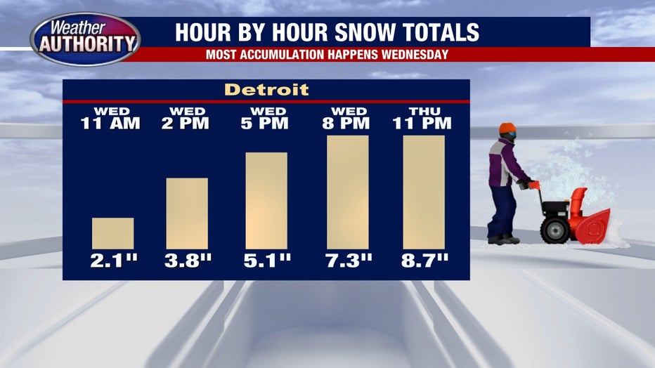
Snow will then fall for almost the entire day Wednesday, shifting between moderate and heavy snow throughout the day. Wednesday morning commuters should plan on roughly 1" of snow on the ground by the time they drive into work between 6-8 am.
How much snow will Michigan get?
We expect most cities to fall within our range of 8 to 12 inches, with higher amounts still possible in Monroe, Lenawee and Southern Washtenaw Counties. With this snowstorm, the closer you are to the Ohio and Indiana state lines, the more snow you'll see.
MORE: What to have on hand if the power goes out during a winter storm
The snow will pile up quickly on Wednesday, by lunchtime there will likely be 2 to 4 inches on the ground.
The commute time home on Wednesday evening will be a mess, with between 5 and 7 already piling up. Traffic will be moving slowly as plow trucks do the best they can.
RELATED: How to drive in a snowstorm
Snow will continue to fall through the evening and overnight but by midnight the bulk of the accumulation will come to an end. At this point, we will have around 8-10" of snow.

When does the snow end in Michigan?
Thursday's storm path has shifted south, meaning areas in Indiana and Ohio will still see several more inches of accumulating snow. However, most of us in southeast Michigan will not.
Outside of Monroe and Lenawee Counties (more on them in a second) the vast majority of us will only get 1-2" additional snow on Thursday giving us two day totals solidly in the 8-12" range. Thursday will see occasional light to moderate snow, but nothing like what we expect on Wednesday.
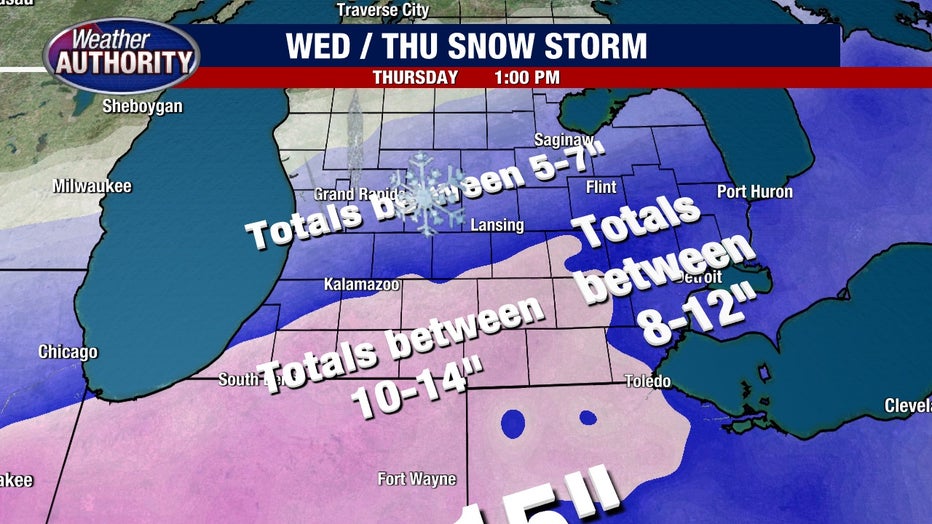
The caveat is Monroe and Lenawee Counties. On Thursday both counties will still be in the target zone, and could pick up 2-4" more snow. Two day totals in this region will likely exceed 12".
Will schools close from the snow in Southeast Michigan?
Yes.
Schools will absolutely close through pretty much the entire area. It will be up to each district whether they close in advance of the storm or not.
Stay up to date on school closings on this page here - where you can also watch our live coverage all day every day.