

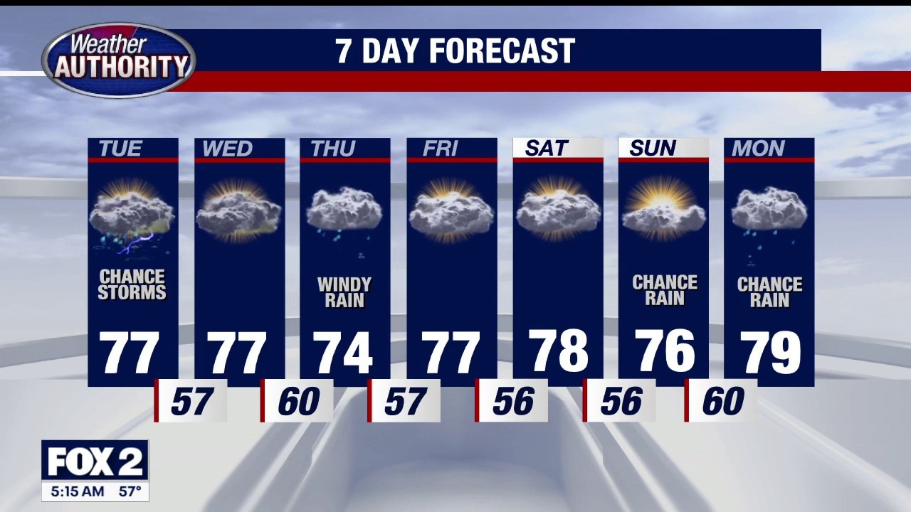
EXTREME HEAT WATCH: Tuesday afternoon through Thursday evening this week. Heat index values could top 105 midweek.
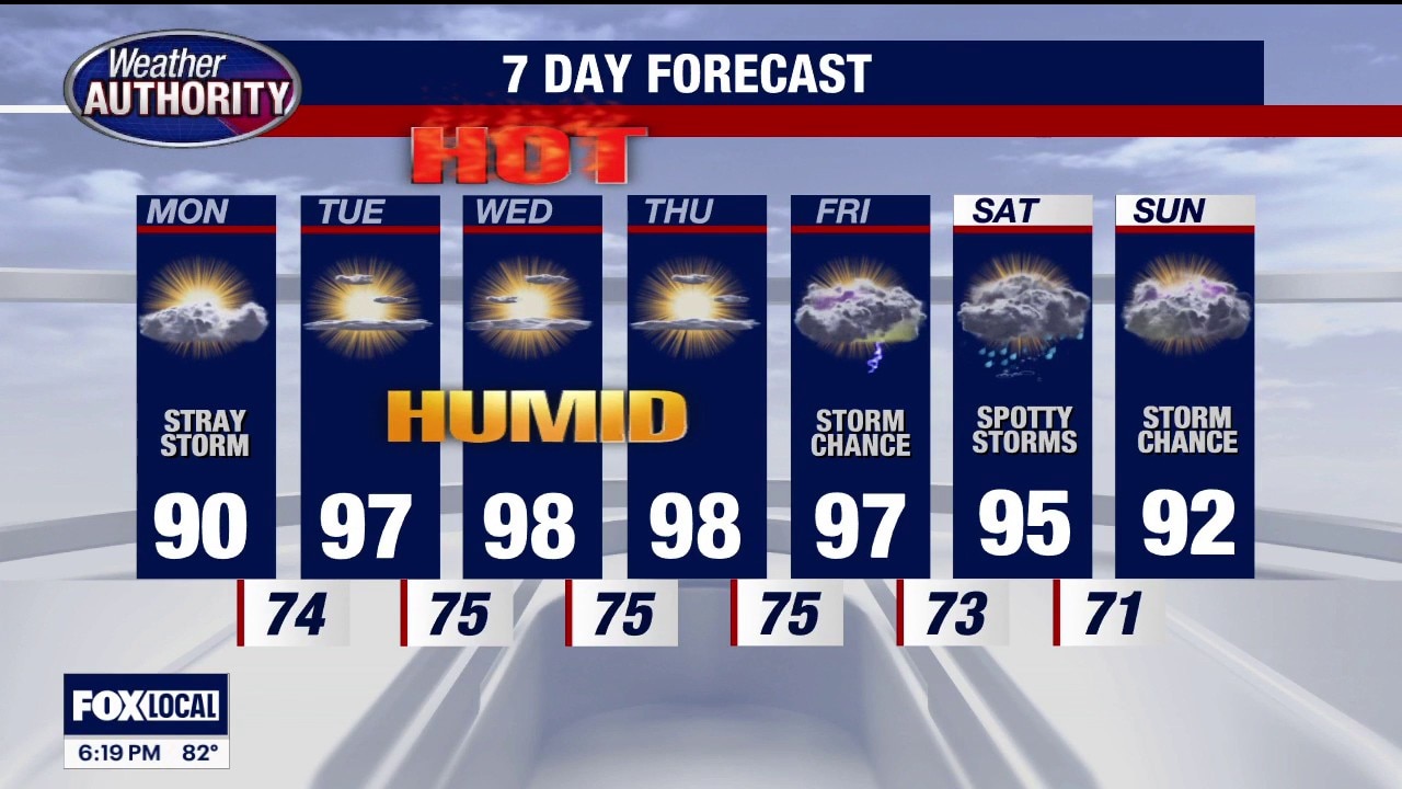
Sunday evening/night: Partly cloudy. Very mild. Low 66. Monday: Partly sunny. VERY WARM & MORE HUMID. Chance for a stray thunderstorm. High near 90. Tuesday: Hazy. HOT AND HUMID. High 97. Wednesday: Hazy. HOT AND HUMID. High 98. Thursday: Hazy. HOT AND HUMID. High 98. Friday: Hazy. HOT AND HUMID. Storm chance. High 97. Saturday (July 4): VERY WARM AND HUMID. With spotty storms. High 95. Sunday: VERY WARM AND HUMID. Storm chance. High 92.
Sunday evening/night: Partly cloudy. Very mild. Low 66. Monday: Partly sunny. VERY WARM & MORE HUMID. Chance for a stray thunderstorm. High near 90. Tuesday: Hazy. HOT AND HUMID. High 97. Wednesday: Hazy. HOT AND HUMID. High 98. Thursday: Hazy. HOT AND HUMID. High 98. Friday: Hazy. HOT AND HUMID. Storm chance. High 97. Saturday (July 4): VERY WARM AND HUMID. With spotty storms. High 95. Sunday: VERY WARM AND HUMID. Storm chance. High 92.
Warmer Sunday
The last day this week without high heat and humidity. Temps this week could exceed 100 degrees. Meteorologist Lori Pinson has your forecast.
The last day this week without high heat and humidity. Temps this week could exceed 100 degrees. Meteorologist Lori Pinson has your forecast.
All eyes are on next week's heat
Some extreme humidity and heat start Monday
Some extreme humidity and heat start Monday
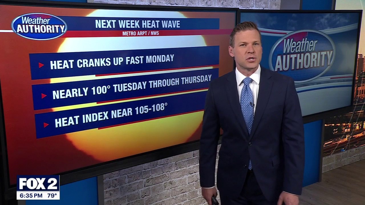
Extreme heat on the way for all of next week
Excessive heat watches and warnings are likely
Excessive heat watches and warnings are likely
Warmer Saturday
Near seasonal values today yet slightly warmer than yesterday. Hot & humid weather on the way next week. Meteorologist Lori Pinson has your forecast
Near seasonal values today yet slightly warmer than yesterday. Hot & humid weather on the way next week. Meteorologist Lori Pinson has your forecast
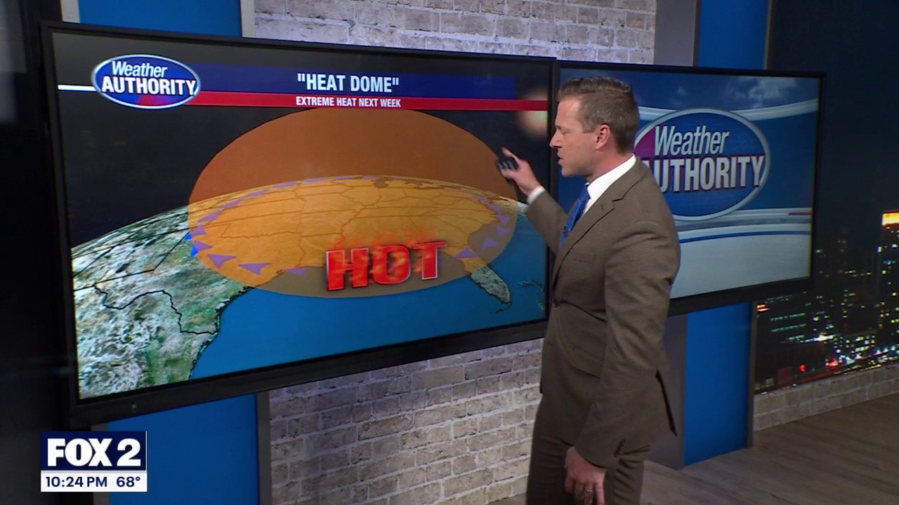
Extreme heat builds in next week
Weekend temps look quite nice!
Weekend temps look quite nice!
Some extreme heat to build in next week
The weekend looks quite nice though!
The weekend looks quite nice though!
Showers return this afternoon
Showers arriving this afternoon with highs in the mid 70s! Rain moves out Thursday with heat and humidity builing through next week!
Showers arriving this afternoon with highs in the mid 70s! Rain moves out Thursday with heat and humidity builing through next week!
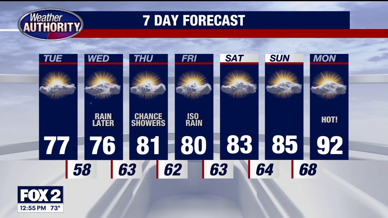
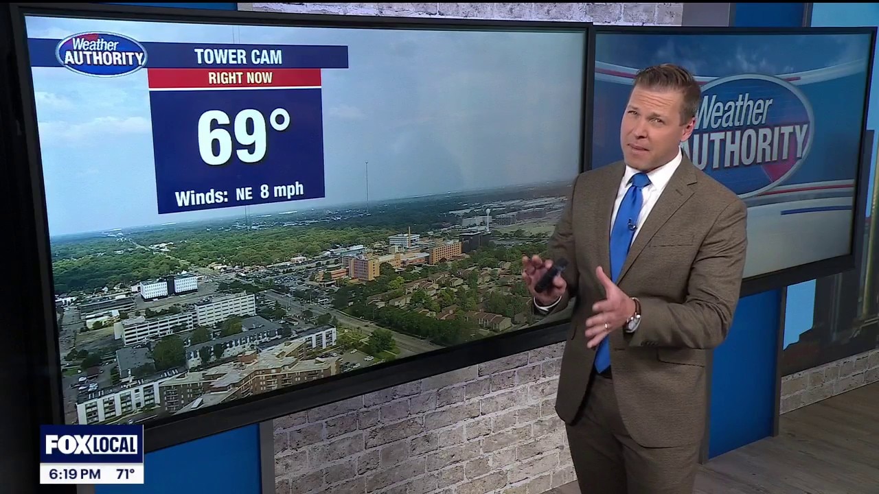
Mild Tuesday
Mostly sunny & warm today with any rain holding off until tomorrow. Hotter temps by the weekend. Meteorologist Lori Pinson has your forecast.
Mostly sunny & warm today with any rain holding off until tomorrow. Hotter temps by the weekend. Meteorologist Lori Pinson has your forecast.


Metro Detroit weather: Wet start to the week, but rain tapers off ahead of Ford Fireworks
It’s a wet start to the day, but we’ll be good to go well before the Ford Fireworks tonight in Downtown Detroit.
It’s a wet start to the day, but we’ll be good to go well before the Ford Fireworks tonight in Downtown Detroit.
Wet start but the rain tapers off before the afternoon
Waking up, it's wet outside, but the rain is expected to move out between 8 a.m. and noon, meaning it will be dry for the Ford Fireworks tonight in Detroit.
Waking up, it's wet outside, but the rain is expected to move out between 8 a.m. and noon, meaning it will be dry for the Ford Fireworks tonight in Detroit.
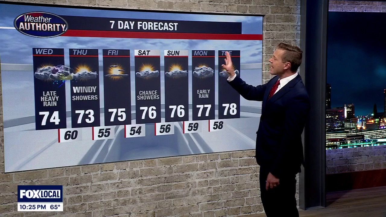
Rain returns
Rain returns this evening with periods of heavy rain closer to Ohio state line. Rain will move out by mid morning Monday. 70s for a good portion of the week!
Rain returns this evening with periods of heavy rain closer to Ohio state line. Rain will move out by mid morning Monday. 70s for a good portion of the week!
Sunny Sunday
Below average temps on this Summer Solstice. Cooler Monday, consistent temps throughout the work week, Meteorologist Lori Pinson has more
Below average temps on this Summer Solstice. Cooler Monday, consistent temps throughout the work week, Meteorologist Lori Pinson has more
Scattered Showers
Most of SE Michigan will remain dry today as a cold front moves across the state. Rain mainly confined north of the city. Father's Day looks sunny and mile. Meteorologist Lori Pinson has your forecast.
Most of SE Michigan will remain dry today as a cold front moves across the state. Rain mainly confined north of the city. Father's Day looks sunny and mile. Meteorologist Lori Pinson has your forecast.
A decent Father's Day forecast
But some rain chances each day
But some rain chances each day
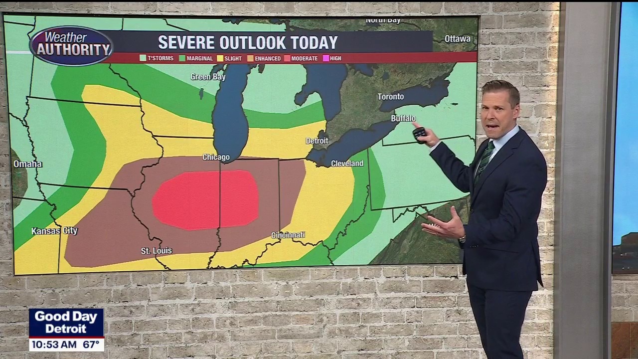
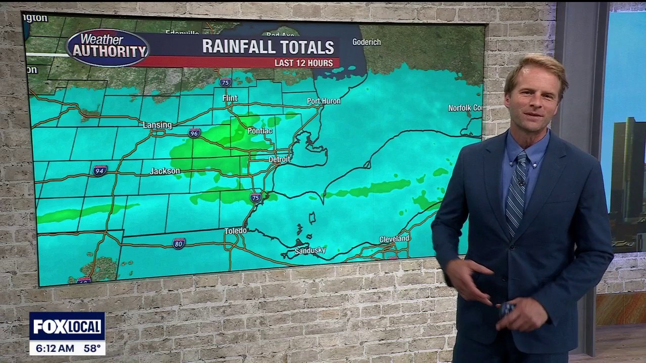
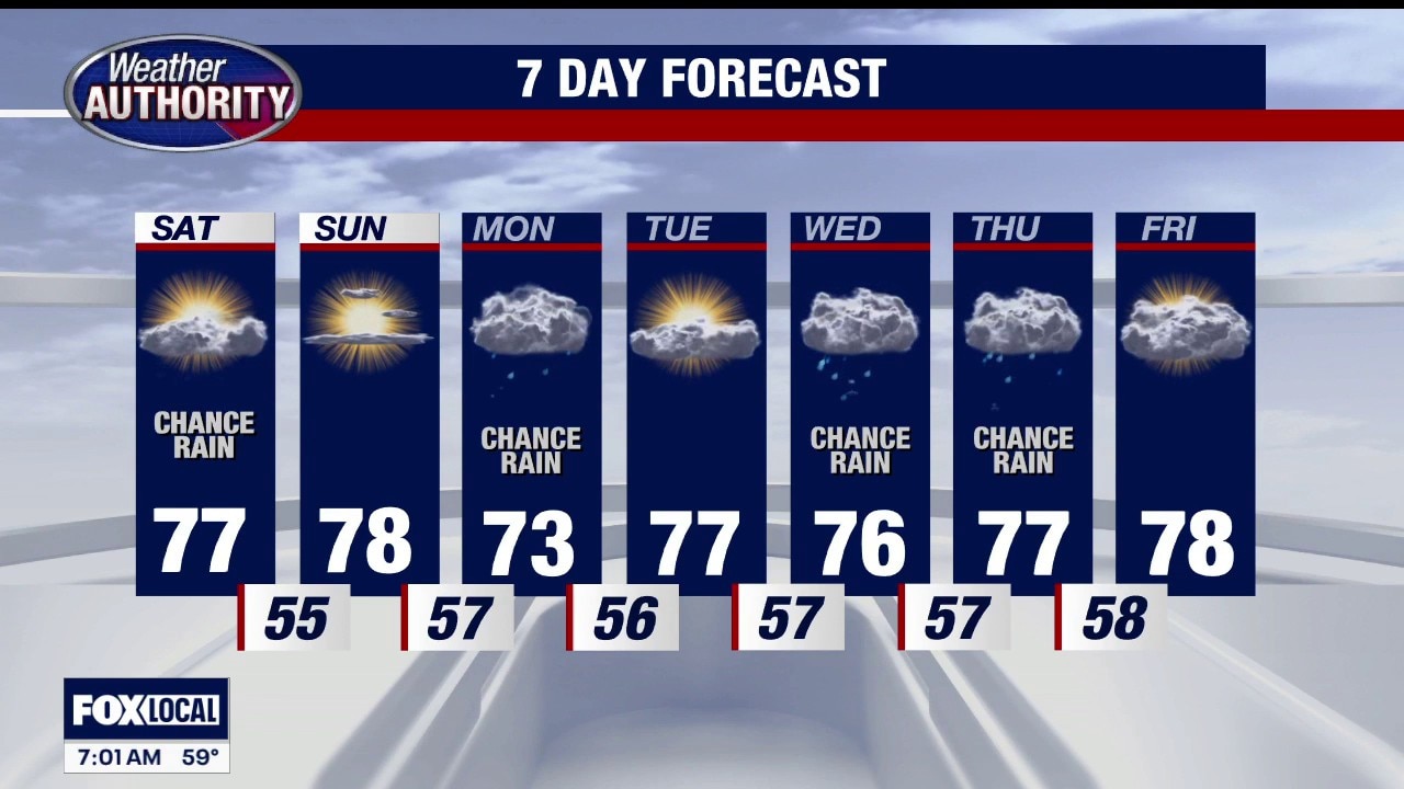
Severe storms and flooding possible Wednesday
The rain could start around 4PM and end near 2AM
The rain could start around 4PM and end near 2AM
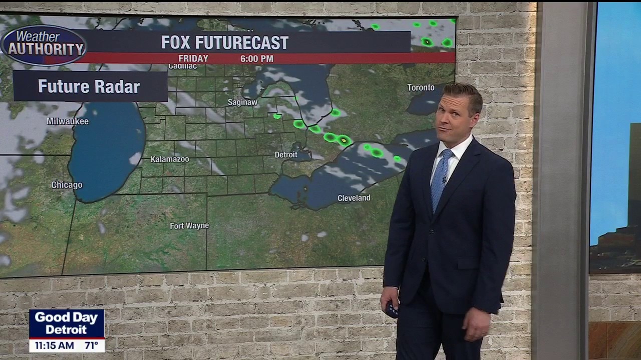
Showers and storms coming to an end tonight
Heaviest rain may push farther south and miss SE MI Wednesday
Heaviest rain may push farther south and miss SE MI Wednesday
Scattered t'storms are still possible through this evening
Heavy rain and possible flooding Wednesday evening too
Heavy rain and possible flooding Wednesday evening too
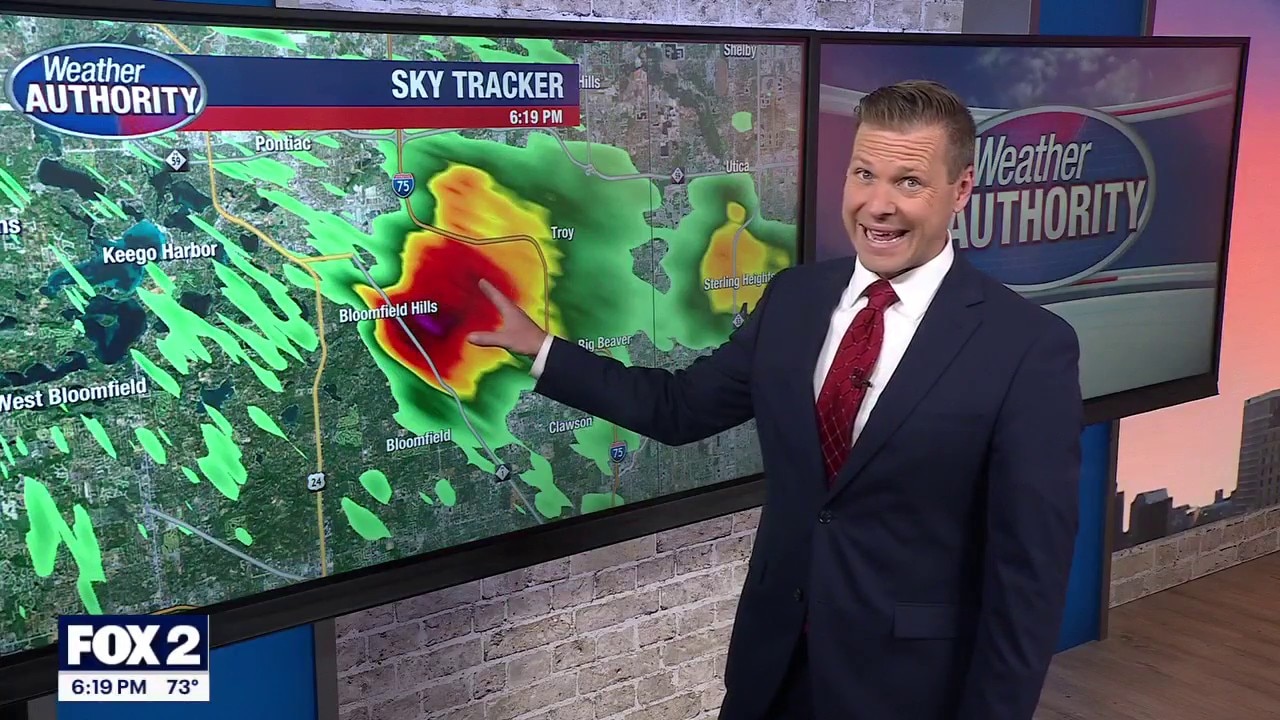
Storm this afternoon and evening
Storm chances return this afternoon and evening wih an isolated storm turning severe. Gusty winds, hail and tornado all in play. More heavy rain arrives Wednesday night with flooding being the main concern Wednesday with 2-3" of rain by early Thursday morning.
Storm chances return this afternoon and evening wih an isolated storm turning severe. Gusty winds, hail and tornado all in play. More heavy rain arrives Wednesday night with flooding being the main concern Wednesday with 2-3" of rain by early Thursday morning.
Storms Possible Today
The potential for severe weather today for later this afternoon extending into the evening. Meteorologist Lori Pinson has your forecast.
The potential for severe weather today for later this afternoon extending into the evening. Meteorologist Lori Pinson has your forecast.