


Michigan severe weather: Live updates as storms roll through Metro Detroit
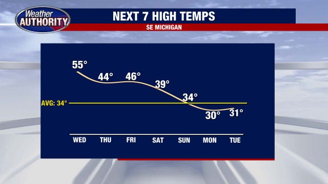
After a week of warmer weather in Metro Detroit, showers and thunderstorms are starting to form, with some rolling into the area Wednesday evening.
After a week of warmer weather in Metro Detroit, showers and thunderstorms are starting to form, with some rolling into the area Wednesday evening.


Lake Tahoe avalanche: 8 backcountry skiers dead, 1 still missing
Nevada County Sheriff Shannan Moon said in addition to those who died, there were six people rescued, whose ages range from 30 to 55.
Nevada County Sheriff Shannan Moon said in addition to those who died, there were six people rescued, whose ages range from 30 to 55.


Rain end late this afternoon
Drier second half of te day with highs ranging from the 40s to the upper 50s! Another chance for rain to end the week with winter returns this weekend.
Drier second half of te day with highs ranging from the 40s to the upper 50s! Another chance for rain to end the week with winter returns this weekend.

Metro Detroit weather: Rainy with highs in the 50s before temps start heading back down
Much of Southeast Michigan will see highs in the 50s today before temps start dropping back toward seasonal.
Much of Southeast Michigan will see highs in the 50s today before temps start dropping back toward seasonal.


Wet and warmer day in Metro Detroit
Highs will be in the 50s Wednesday, but with it comes rain and even the possibility for a rumble of thunder.
Highs will be in the 50s Wednesday, but with it comes rain and even the possibility for a rumble of thunder.


A chance for 60 degrees on Wednesday
Rich Luterman has the forecast.
Rich Luterman has the forecast.


Nice day today; Rain returns Wednesday morning!
Another nice day with highs in the upper 40s to lower 50s with a mix of sun and clouds! Rain returns overnight and through early Wednesday morning. Highs will also soar to the lower 60s Wednesay. More rain to end te week with much colder conditions this weekend!
Another nice day with highs in the upper 40s to lower 50s with a mix of sun and clouds! Rain returns overnight and through early Wednesday morning. Highs will also soar to the lower 60s Wednesay. More rain to end te week with much colder conditions this weekend!


Metro Detroit weather: Another foggy start to a dry day before the rain arrives
Tuesday starts foggy but will remain dry before rain and temperatures near 60 arrive in Metro Detroit.
Tuesday starts foggy but will remain dry before rain and temperatures near 60 arrive in Metro Detroit.


Dense Fog Advisory
Patchy dense fog is bringing the visibility down to 0 in some locations. Give yourself extra time if you're headed out this morning. Rain moving in overnight. Meteorologist Lori Pinson has your forecast.
Patchy dense fog is bringing the visibility down to 0 in some locations. Give yourself extra time if you're headed out this morning. Rain moving in overnight. Meteorologist Lori Pinson has your forecast.


Foggy start to Tuesday
Another foggy start to another day with above seasonal temperatures.
Another foggy start to another day with above seasonal temperatures.


Berkley crews working to fix broken water mains amid warmer weather
Much of southeast Michigan is getting a welcomed break from the harsh winter weather, with some parts of metro Detroit seeing temperatures in the 50s on Monday. But unfortunately, the warmer weather often leads to water main breaks.
Much of southeast Michigan is getting a welcomed break from the harsh winter weather, with some parts of metro Detroit seeing temperatures in the 50s on Monday. But unfortunately, the warmer weather often leads to water main breaks.


Mostly cloudy and mild for Tuesday
Rich Luterman has the forecast.
Rich Luterman has the forecast.


Mild start to the weekend
A great day with a mix of sun and clouds. We'll see that spill over into Tuesday. Next chance for rain and wind arrive Wednesday with highs approaching 60°!
A great day with a mix of sun and clouds. We'll see that spill over into Tuesday. Next chance for rain and wind arrive Wednesday with highs approaching 60°!


Metro Detroit weather: Foggy start to another day with highs above average
Air quality will again be an issue in Metro Detroit for people who have respiratory concerns, as snow continues to melt.
Air quality will again be an issue in Metro Detroit for people who have respiratory concerns, as snow continues to melt.


Air Quality Advisory This Morning
If you have respiratory concerns, limit the time you'll be outdoors today. Air Quality Advisory expires at noon. Patchy fog for some to start the day. Meteorologist Lori Pinson has your forecast.
If you have respiratory concerns, limit the time you'll be outdoors today. Air Quality Advisory expires at noon. Patchy fog for some to start the day. Meteorologist Lori Pinson has your forecast.


Temps could hit 60 by midweek
An air quality alert continues through noon Monday. Our mild pattern continues this week. Some wet weather comes Wednesday and Friday morning. Rest of Sunday evening / night…. Partly cloudy… areas of fog…. Low 28 Monday (PRESIDENTS DAY): Mostly cloudy… breezy at times… high 47 Tuesday: Mostly cloudy… high 45 Wednesday: Cloudy with rain showers… VERY MILD…. high 57 Thursday: Mostly cloudy…. still mild….high 52 Friday: Cloudy…. morning showers…high 47 Saturday: Mostly cloudy…. cooler…. high 39
An air quality alert continues through noon Monday. Our mild pattern continues this week. Some wet weather comes Wednesday and Friday morning. Rest of Sunday evening / night…. Partly cloudy… areas of fog…. Low 28 Monday (PRESIDENTS DAY): Mostly cloudy… breezy at times… high 47 Tuesday: Mostly cloudy… high 45 Wednesday: Cloudy with rain showers… VERY MILD…. high 57 Thursday: Mostly cloudy…. still mild….high 52 Friday: Cloudy…. morning showers…high 47 Saturday: Mostly cloudy…. cooler…. high 39


Air quality alert continues through Monday; warmer weather this week
An air quality alert continues through noon Monday. Our mild pattern continues this week. Some wet weather comes Wednesday and Friday morning. Rest of Sunday evening / night…. Partly cloudy… areas of fog…. Low 28 Monday (PRESIDENTS DAY): Mostly cloudy… breezy at times… high 47 Tuesday: Mostly cloudy… high 45 Wednesday: Cloudy with rain showers… VERY MILD…. high 57 Thursday: Mostly cloudy…. still mild….high 52 Friday: Cloudy…. morning showers…high 47 Saturday: Mostly cloudy…. cooler…. high 39
An air quality alert continues through noon Monday. Our mild pattern continues this week. Some wet weather comes Wednesday and Friday morning. Rest of Sunday evening / night…. Partly cloudy… areas of fog…. Low 28 Monday (PRESIDENTS DAY): Mostly cloudy… breezy at times… high 47 Tuesday: Mostly cloudy… high 45 Wednesday: Cloudy with rain showers… VERY MILD…. high 57 Thursday: Mostly cloudy…. still mild….high 52 Friday: Cloudy…. morning showers…high 47 Saturday: Mostly cloudy…. cooler…. high 39


Sunday Morning Fog
Patchy fog reported this morning reducing visibilities to a mile. Above seasonal temperatures continue. Meteorologist Lori Pinson has your forecast
Patchy fog reported this morning reducing visibilities to a mile. Above seasonal temperatures continue. Meteorologist Lori Pinson has your forecast


Nice end to the weekend
Mild but cloudy end to the weekened. Highs through the first half of the work week look to come close to 50° with sun and clouds. Mid weel system brings in rain and wind!
Mild but cloudy end to the weekened. Highs through the first half of the work week look to come close to 50° with sun and clouds. Mid weel system brings in rain and wind!