


Severe weather watches and warnings in effect overnight
Derek Kevra tells us what to expect.
Derek Kevra tells us what to expect.

Severe weather moves in with two bands of storms
Derek Kevra has details on the severe storms moving through SE Michigan.
Derek Kevra has details on the severe storms moving through SE Michigan.

Severe weather rolling through SE Michigan
Strong storms are moving into the area, here is what to expect
Strong storms are moving into the area, here is what to expect

Strong storms moving into SE Michigan
High winds, heavy rain and severe thunderstorms are expected from 10 p.m. to 2 a.m.
High winds, heavy rain and severe thunderstorms are expected from 10 p.m. to 2 a.m.

Storms to finish the week may pack a punch. Severe weather is possible late today into the night.
We're drying out for most of the weekend!
We're drying out for most of the weekend!

Chance for strong storms Friday night
Rich Luterman has the forecast.
Rich Luterman has the forecast.
Warming up
Rich Luterman has the forecast.
Rich Luterman has the forecast.


Massive Saharan dust plume reaches US — here’s what you need to know
The plume of dusty air reached the United States Thursday, bringing dust particles to sections of the South.
The plume of dusty air reached the United States Thursday, bringing dust particles to sections of the South.


Saharan dust cloud may come to Michigan, likely to be dampened by rain
Particles of dust from the Saharan Desert in Africa may make it to Michigan this weekend.
Particles of dust from the Saharan Desert in Africa may make it to Michigan this weekend.

Friday Night Storms
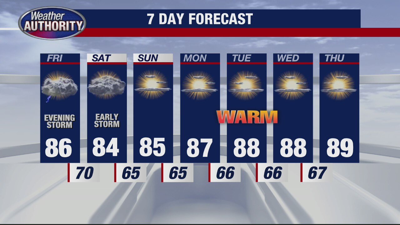
Thursday looks great here in Metro Detroit. Expect a mix of clouds and sunshine along with temperatures in the upper 70s to near 80 degrees. Though an isolated shower is possible, most of us should stay nice and dry today. Friday morning and Friday afternoon look good with highs spiking in the mid and upper 80s. That heat and humidity will help to fuel a line of scattered showers and thunderstorms Friday evening after sunset. Our main threat will be damaging winds. Down trees and power lines are possible. Stay weather aware Friday after sunset through sunrise on Saturday.
Thursday looks great here in Metro Detroit. Expect a mix of clouds and sunshine along with temperatures in the upper 70s to near 80 degrees. Though an isolated shower is possible, most of us should stay nice and dry today. Friday morning and Friday afternoon look good with highs spiking in the mid and upper 80s. That heat and humidity will help to fuel a line of scattered showers and thunderstorms Friday evening after sunset. Our main threat will be damaging winds. Down trees and power lines are possible. Stay weather aware Friday after sunset through sunrise on Saturday.

How Dust from the Sahara Desert Gets to the United States
By this point, I?m sure you?ve heard that there is a large plume of Saharan Dust from the African continent that has traveled across the Atlantic Ocean and is having significant impacts on the daylight and air quality in the Caribbean.
By this point, I?m sure you?ve heard that there is a large plume of Saharan Dust from the African continent that has traveled across the Atlantic Ocean and is having significant impacts on the daylight and air quality in the Caribbean.

Another "cool" day with the summer feel lurking. Storms roll through Friday night!
Friday night storms may be strong or severe.
Friday night storms may be strong or severe.

Chance for a shower Thursday
Rich Luterman has the forecast and things will be warming up.
Rich Luterman has the forecast and things will be warming up.
A warm up for the weekend
Rich Luterman has the forecast.
Rich Luterman has the forecast.


The Arctic is on fire: Siberian heat wave alarms scientists
On Saturday, the thermometer hit a likely record of 38 degrees Celsius — or 100.4 degrees Fahrenheit — in the Siberian town of Verkhoyansk in Russia’s Sakha Republic.
On Saturday, the thermometer hit a likely record of 38 degrees Celsius — or 100.4 degrees Fahrenheit — in the Siberian town of Verkhoyansk in Russia’s Sakha Republic.

Weekend Storm Chances
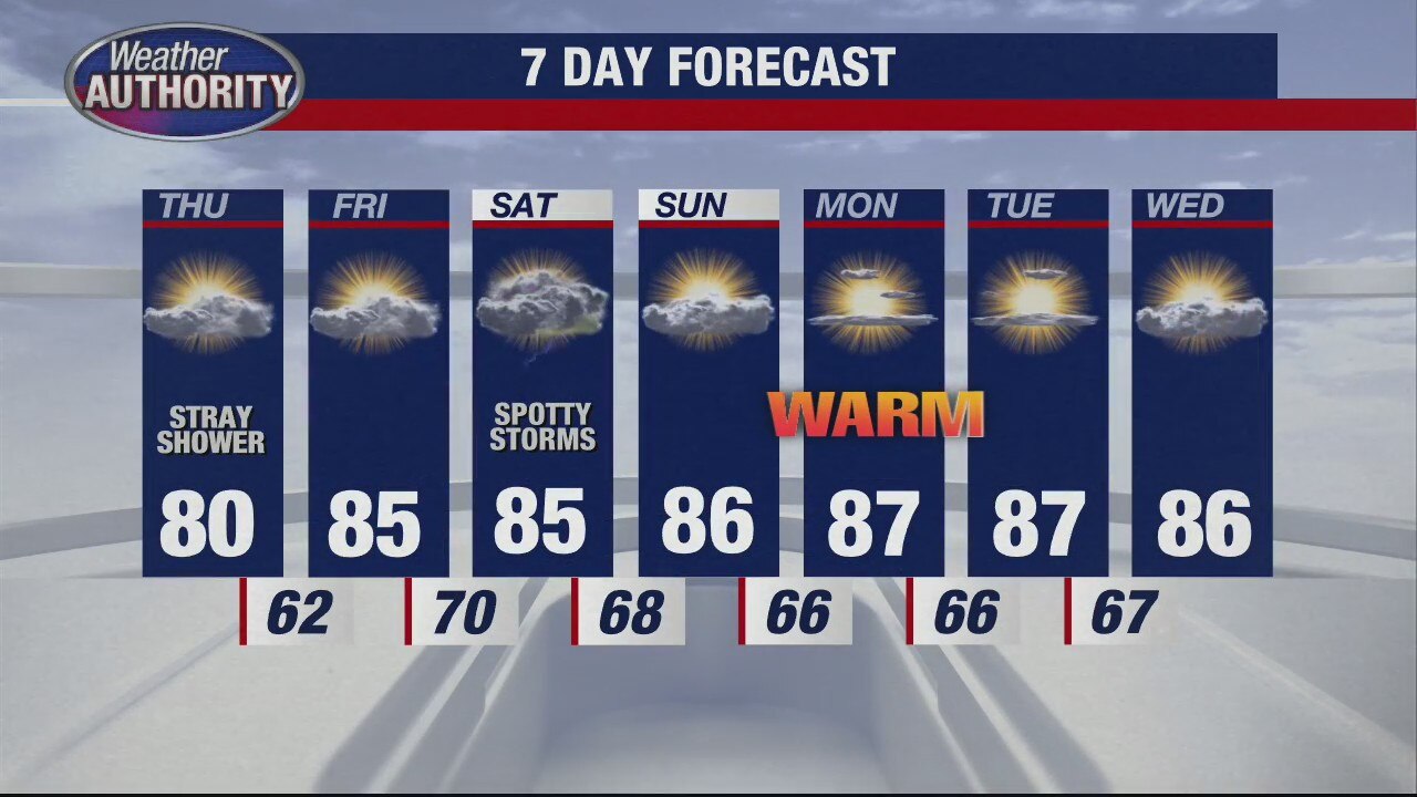
What a beautiful Wednesday in southeast Michigan. We are noticeably cooler with lower humidity. High temperatures should make it into the mid and upper 70s. Though a passing sprinkle is possible in Sanilac and St. Clair counties, most areas should stay nice and dry. Upper 50s and low 60s are expected overnight under mostly clear skies. Another great day is on top tomorrow with 70s and sunshine. Enjoy the refreshingly cool air because we will warm things back up into the 80s by Friday and beyond.
What a beautiful Wednesday in southeast Michigan. We are noticeably cooler with lower humidity. High temperatures should make it into the mid and upper 70s. Though a passing sprinkle is possible in Sanilac and St. Clair counties, most areas should stay nice and dry. Upper 50s and low 60s are expected overnight under mostly clear skies. Another great day is on top tomorrow with 70s and sunshine. Enjoy the refreshingly cool air because we will warm things back up into the 80s by Friday and beyond.

Cooler for a couple with a weekend warm up on the way!
Temps linger in the 70's without much rain for the week.
Temps linger in the 70's without much rain for the week.

The cool down is here
Rich Luterman has the mild forecast.
Rich Luterman has the mild forecast.

Tuesday morning rain is ending, wind is picking up a bit.
Our midweek cool down is coming!
Our midweek cool down is coming!

Some Tuesday morning showers with lower humidity on the way!
It will be windy and less humid this afternoon.
It will be windy and less humid this afternoon.