


Extremely cold weather continues for Metro Detroit
Wind Chill numbers will bottom out near -13 degrees
Wind Chill numbers will bottom out near -13 degrees

Sub Zero Wind Chills Tonight
Falling temperatures today coupled with a strong wind brings wind chills in the single digits and sub zero range overnight. Meteorologist Lori Pinson has your forecast.
Falling temperatures today coupled with a strong wind brings wind chills in the single digits and sub zero range overnight. Meteorologist Lori Pinson has your forecast.

Frigid weekend
Teens to start and end the weekend with light snow early Saturday morning. Sub-zero windchills Sunday morning!
Teens to start and end the weekend with light snow early Saturday morning. Sub-zero windchills Sunday morning!

Arctic chill ready to arrive this weekend
Dangerous cold weather on tap for Saturday night and Sunday morning
Dangerous cold weather on tap for Saturday night and Sunday morning


Metro Detroit weather: Bitter cold weekend with negative wind chills ahead
After a wild week of weather, a calm finish is on the way, but it leads into a bitter cold weekend in Metro Detroit.
After a wild week of weather, a calm finish is on the way, but it leads into a bitter cold weekend in Metro Detroit.

Bitter cold weekend ahead
The week ends calm, but the cold is really starting to settle in for the weekend.
The week ends calm, but the cold is really starting to settle in for the weekend.

Cloudy and cool for Friday
Rich Luterman has the forecast.
Rich Luterman has the forecast.

Some flurries and cold air for your Thursday
Icy conditions persist for the weekend and beyond
Icy conditions persist for the weekend and beyond


Metro Detroit weather: Snow is gone, but the cold is just getting started
The snow’s gone and the cold is just getting started in Metro Detroit, with bitter temps arriving for the weekend.
The snow’s gone and the cold is just getting started in Metro Detroit, with bitter temps arriving for the weekend.

Snow moves out but bitter cold approaches
The weather has quieted down after two rounds of snow in Metro Detroit, bitter cold is on the way.
The weather has quieted down after two rounds of snow in Metro Detroit, bitter cold is on the way.

Cold stretch ahead
Cold tonight with windchills in the single digits. Icy start with highs in the lower to mid 20s. 20s stick around through the weekend.
Cold tonight with windchills in the single digits. Icy start with highs in the lower to mid 20s. 20s stick around through the weekend.

The heavy snow is over but some remaining rain/snow could affect us
By dinner time we will see the whole system leave, as we dry out
By dinner time we will see the whole system leave, as we dry out


Metro Detroit weather: Rain mixing in after snow could lead to tricky driving later Wednesday
A burst of overnight snow has rendered the roads a mess, but the good news is rain is mixing in and temps are climbing, helping road cleanup as we move through the morning.
A burst of overnight snow has rendered the roads a mess, but the good news is rain is mixing in and temps are climbing, helping road cleanup as we move through the morning.

Rain mixing in this morning after overnight snow
Snow is coating Southeast Michigan roads, but rain is mixing in and rain is falling, so the roads should begin clearing as we move through the morning. Alan Longstreet has what to expect for the rest of the day.
Snow is coating Southeast Michigan roads, but rain is mixing in and rain is falling, so the roads should begin clearing as we move through the morning. Alan Longstreet has what to expect for the rest of the day.

Winter weather conditions crescendo as second wave of snow brings dangerous conditions
Things get more interesting by Wednesday morning as most areas in the tri-county area could see snow transition to rain. Monroe and Lenawee counties can expect to see that switch first as the line of below- and above-freezing temperatures pushes north.
Things get more interesting by Wednesday morning as most areas in the tri-county area could see snow transition to rain. Monroe and Lenawee counties can expect to see that switch first as the line of below- and above-freezing temperatures pushes north.

Snow then rain take aim at Metro Detroit
The winter weather is not done in Southeast Michigan with another band of snow taking aim at the region. Complicating the forecast is the chance for rain to replace snow by Wednesday morning.
The winter weather is not done in Southeast Michigan with another band of snow taking aim at the region. Complicating the forecast is the chance for rain to replace snow by Wednesday morning.
Snow overnight
Snow arrives tonight at about 10 pm! 2-4" by Wednesday morning. Turning uch colder through the end of the week with highs in the 20s through the weekend!
Snow arrives tonight at about 10 pm! 2-4" by Wednesday morning. Turning uch colder through the end of the week with highs in the 20s through the weekend!

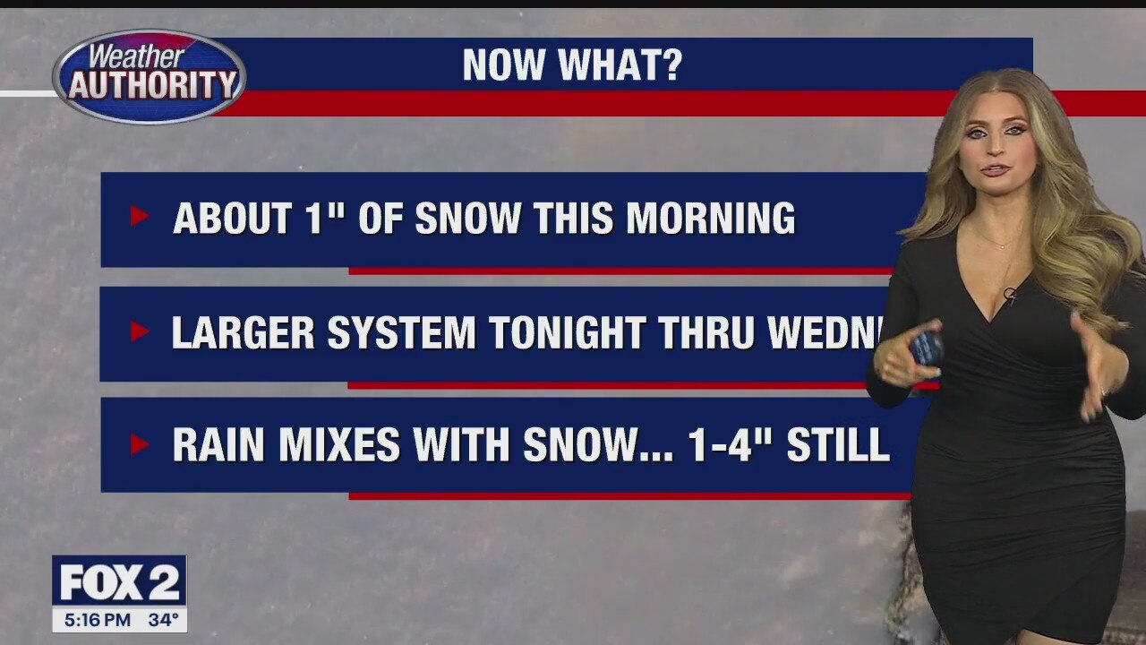
Snow Returning Tonight
Snow ending this morning with most areas receiving between 1 and 2 inches. Snow returning this evening, mixing with rain, but increasing snow totals tomorrow. Meteorologist Lori Pinson has your forecast.
Snow ending this morning with most areas receiving between 1 and 2 inches. Snow returning this evening, mixing with rain, but increasing snow totals tomorrow. Meteorologist Lori Pinson has your forecast.

Light Snow This Morning
Light snow reducing visibilities this morning will taper off by the afternoon. A mix of rain and snow Wednesday. Meteorologist Lori Pinson has your forecast.
Light snow reducing visibilities this morning will taper off by the afternoon. A mix of rain and snow Wednesday. Meteorologist Lori Pinson has your forecast.


Metro Detroit weather: 2 rounds of snow today and tomorrow
Southeast Michigan is set to see two rounds of snow between Tuesday and Wednesday. See expected snow totals for Metro Detroit here.
Southeast Michigan is set to see two rounds of snow between Tuesday and Wednesday. See expected snow totals for Metro Detroit here.