


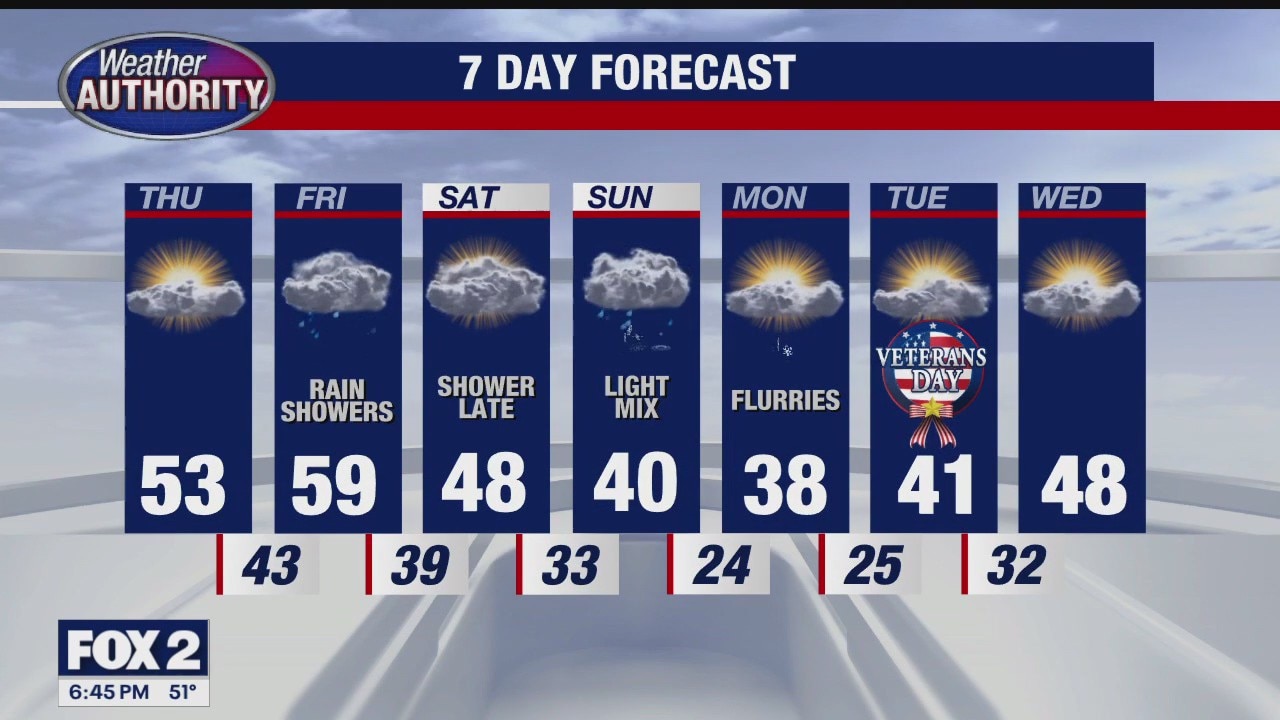
Warmer for Wednesday
Rich Luterman has the forecast.
Rich Luterman has the forecast.
Some flurries possible on your Tuesday
Temperatures start climbing up beginning tomorrow
Temperatures start climbing up beginning tomorrow


Metro Detroit weather: Another cold day before the warm-up begins
It will be another cold day in Metro Detroit, but a change of wind direction later will lead to warmer temps as the week progresses.
It will be another cold day in Metro Detroit, but a change of wind direction later will lead to warmer temps as the week progresses.

Veterans Day Outlook
Another cold start to the day with wind chills in the teens. A warm up starts tomorrow. Meteorologist Lori Pinson has your forecast.
Another cold start to the day with wind chills in the teens. A warm up starts tomorrow. Meteorologist Lori Pinson has your forecast.

Cold, winter like weather continues
Snow threats remain low but cold, icy conditions stick around
Snow threats remain low but cold, icy conditions stick around

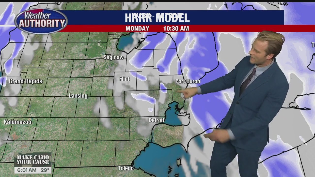
Cold, Windy Monday
Wind chill values in the teens today with lake effect snow possible. Meteorologist Lori Pinson has your forecast
Wind chill values in the teens today with lake effect snow possible. Meteorologist Lori Pinson has your forecast


Metro Detroit weather: Snow fades but cold remains
The snow’s done, but the cold is here to stay – for now.
The snow’s done, but the cold is here to stay – for now.
Snow gone but cold remains
The weekend snow has faded, but the cold sticks around for a bit.
The weekend snow has faded, but the cold sticks around for a bit.

Snowy Sunday
Snow continues, with wind chills in the 20s and reduced visibilities today. Meteorologist Lori Pinson has your forecast
Snow continues, with wind chills in the 20s and reduced visibilities today. Meteorologist Lori Pinson has your forecast

Wintry Sunday!
Rain/snow mix with slushy conditions through the day! Snow accumulation looks minimal with most spots between 1"-2". Turning colder to start the week with feel like temperatures in the teens Monday morning!
Rain/snow mix with slushy conditions through the day! Snow accumulation looks minimal with most spots between 1"-2". Turning colder to start the week with feel like temperatures in the teens Monday morning!

Wintry Mix Coming
Dry to start your Saturday. Rain by evening, changing to snow overnight. Meteorologist Lori Pinson has your forecast.
Dry to start your Saturday. Rain by evening, changing to snow overnight. Meteorologist Lori Pinson has your forecast.

Weekend snow chances
Snow arrives Sunday morning with accumulations between 1"-2"! The follows the cold! Temps top out in the 30s with feel like temperatures Monday morning in the teens!
Snow arrives Sunday morning with accumulations between 1"-2"! The follows the cold! Temps top out in the 30s with feel like temperatures Monday morning in the teens!

Sunday snow looks likely.. but how much?
Rain mixing in as well as warm ground temps may limit accumulation
Rain mixing in as well as warm ground temps may limit accumulation


Metro Detroit weather: Some rain Friday before chance of snow this weekend
Metro Detroit will see rain to end the week, but by Sunday, that rain will be changing as the area is expected to see its first snowflakes of the season.
Metro Detroit will see rain to end the week, but by Sunday, that rain will be changing as the area is expected to see its first snowflakes of the season.

Metro Detroit's first chance of snow this weekend
It's going to be a cold - and potentially snowy - weekend for Metro Detroit. The area's first chance of snow is expected to mix in with Sunday rain, with some areas predicted to even see measurable snow on the grass.
It's going to be a cold - and potentially snowy - weekend for Metro Detroit. The area's first chance of snow is expected to mix in with Sunday rain, with some areas predicted to even see measurable snow on the grass.

Sunday snow still looks likely
Still some questions as to how much and if rain mixes in
Still some questions as to how much and if rain mixes in


Metro Detroit weather: Sunny day with highs in the 50s before the weekend cold
Winter’s coming this weekend for Metro Detroit, but we have to make it through the week first.
Winter’s coming this weekend for Metro Detroit, but we have to make it through the week first.

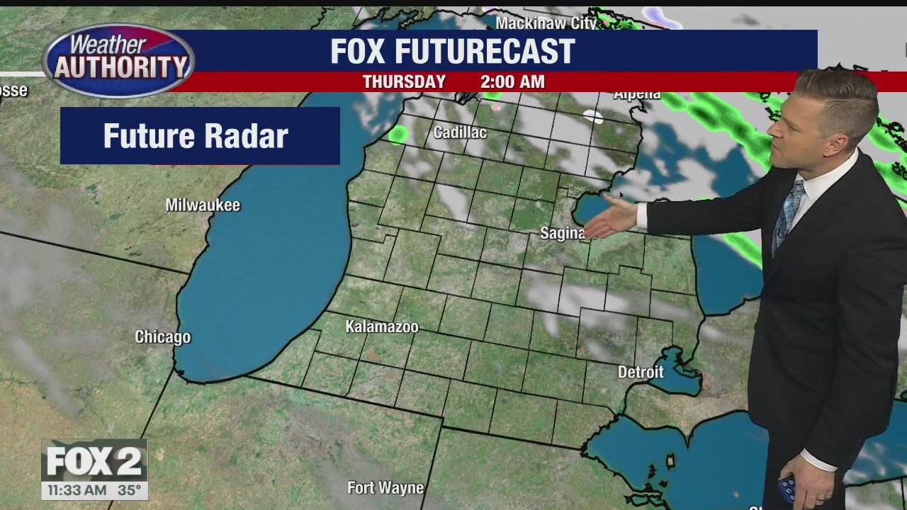
Sunshine again Thursday
A cool start ahead of a sunny day with highs in the low 50s.
A cool start ahead of a sunny day with highs in the low 50s.
Colder Weekend Ahead
Dry weather expected overnight into Thursday. Rain Friday then much colder air with the chance of a wintry mix by the weekend. Meteorologist Lori Pinson has your forecast.
Dry weather expected overnight into Thursday. Rain Friday then much colder air with the chance of a wintry mix by the weekend. Meteorologist Lori Pinson has your forecast.

Some showers today but everyone watching Sunday snow
Yes it's likely but how much?
Yes it's likely but how much?