


Wind Advisory overnight with some rain Thursday
Rich Luterman has the forecast.
Rich Luterman has the forecast.
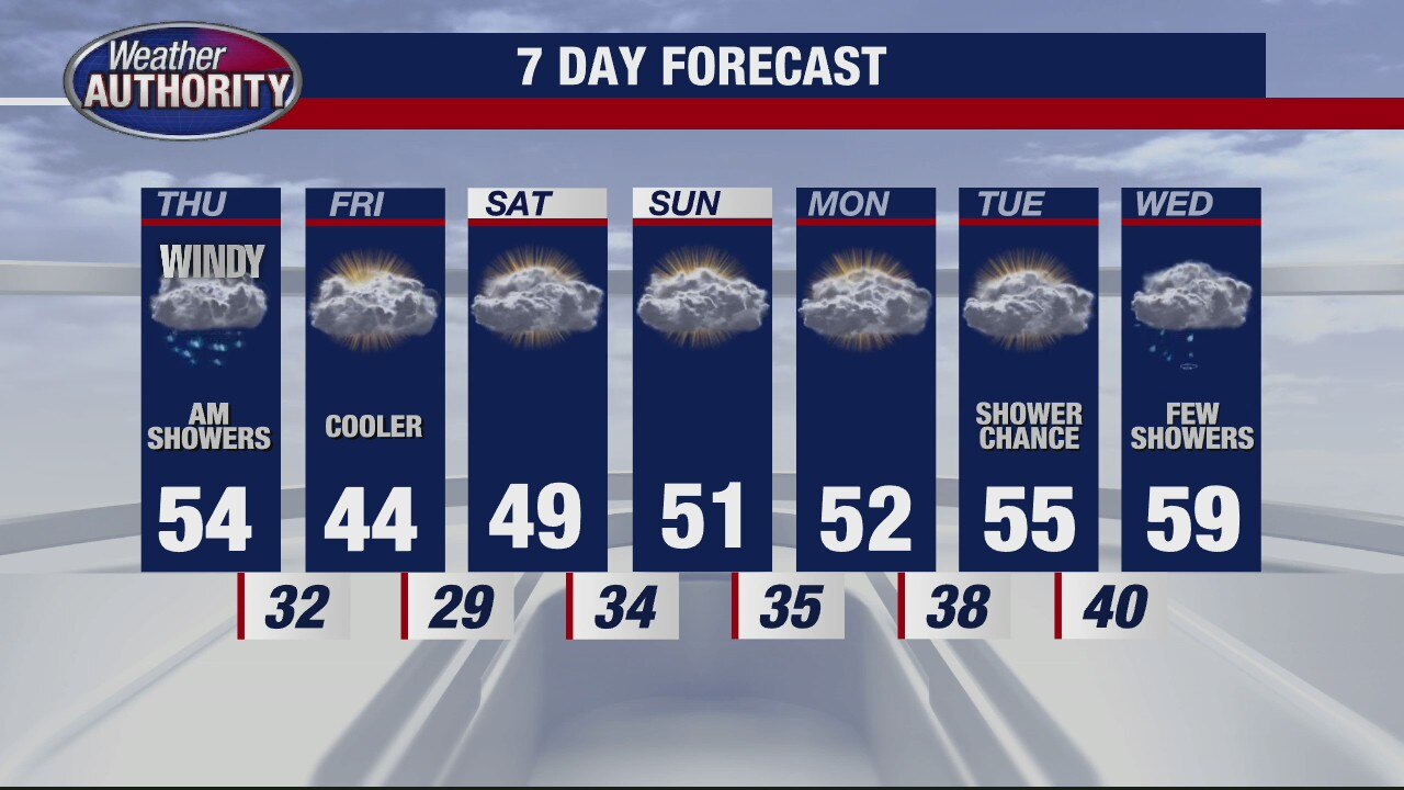
Blustery with some early rain Thursday
Rich Luterman has the forecast.
Rich Luterman has the forecast.


Metro Detroit under Wind Advisory from midnight to 4 p.m. Thursday
Strong southwest winds from about 20 to 25 mph with gusts up to 45 to 50 miles per hour are expected tonight into Thursday. Peak wind gusts are anticipated in the 6 a.m. to 12 p.m. timeframe.
Strong southwest winds from about 20 to 25 mph with gusts up to 45 to 50 miles per hour are expected tonight into Thursday. Peak wind gusts are anticipated in the 6 a.m. to 12 p.m. timeframe.

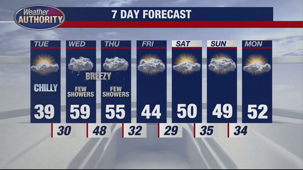
Warmer air coming our way
But the showers still stick around
But the showers still stick around


Strong solar storm could trigger Northern Lights as far south as Iowa
NOAA's Space Weather Prediction Center has issued a Geomagnetic Storm Watch and predicts the storm could reach level 3 on their 5-level scale when the flares arrive around Wednesday evening.
NOAA's Space Weather Prediction Center has issued a Geomagnetic Storm Watch and predicts the storm could reach level 3 on their 5-level scale when the flares arrive around Wednesday evening.


Freezing rain Wednesday morning before temperatures surge into the 50s
During periods of freezing rain, bridges, overpasses, and ramps will be susceptible to icing, as will a lot of other roads that could be slick before sunrise. After the sun is up, it'll look like a very different day.
During periods of freezing rain, bridges, overpasses, and ramps will be susceptible to icing, as will a lot of other roads that could be slick before sunrise. After the sun is up, it'll look like a very different day.

Slick Spots Wednesday Morning
Freezing Rain is possible this morning! That will lead to slick and slippery spots especially on bridges, overpasses, on-ramps and off-ramps. Temperatures will eventually warm above freezing by late morning. By this afternoon, highs will surge into the 50s before topping out near 60 degrees this evening. Rain and wind is expected tonight and through the day tomorrow.
Freezing Rain is possible this morning! That will lead to slick and slippery spots especially on bridges, overpasses, on-ramps and off-ramps. Temperatures will eventually warm above freezing by late morning. By this afternoon, highs will surge into the 50s before topping out near 60 degrees this evening. Rain and wind is expected tonight and through the day tomorrow.

Wintery mix overnight - then warmer temps
Rich Luterman has the forecast.
Rich Luterman has the forecast.


Winter weather Tuesday night will bring burst of snow, freezing rain to Southeast Michigan
Temperatures may warm as high as 60 degrees Wednesday. That's the good news. The bad news is the snow and freezing rain expected to fall overnight.
Temperatures may warm as high as 60 degrees Wednesday. That's the good news. The bad news is the snow and freezing rain expected to fall overnight.


Winter weather advisory in Southeast Michigan Tuesday night and 60 degree weather Wednesday
Get ready for a bit of chaos in the weather world the next two days as conditions swing from winter and a burst of snow tonight to a surge in temperatures tomorrow.
Get ready for a bit of chaos in the weather world the next two days as conditions swing from winter and a burst of snow tonight to a surge in temperatures tomorrow.

Cold temps stick around for one more day
Rich Luterman has the forecast.
Rich Luterman has the forecast.
Still cold for Tuesday
Rich Luterman has the forecast.
Rich Luterman has the forecast.


Winter not done yet with a freezing start to the week in Southeast Michigan
A brutal wind chill starts us out in the single digits Monday morning. Conditions will get better but warm air won't arrive until the mid-week when temperatures swing up near 60 degrees.
A brutal wind chill starts us out in the single digits Monday morning. Conditions will get better but warm air won't arrive until the mid-week when temperatures swing up near 60 degrees.
Sunday Morning Snow Flurries
Although we're tracking snow flurries this morning, expect more clouds, more wind and more cold air this afternoon. The lake effect snow flurries should wind down around lunchtime today with highs only in the upper 20s and low 30s.
Although we're tracking snow flurries this morning, expect more clouds, more wind and more cold air this afternoon. The lake effect snow flurries should wind down around lunchtime today with highs only in the upper 20s and low 30s.

Preventing Ticks and Fleas this Spring Season
The one and only, Mike Palmer, from Premier Pet Supply joined us to talk about what we can do to help prevent ticks and fleas from jumping on our furry friends as we head into the spring and summer months.
The one and only, Mike Palmer, from Premier Pet Supply joined us to talk about what we can do to help prevent ticks and fleas from jumping on our furry friends as we head into the spring and summer months.
A cold weekend continues
More light snowflakes are possible too.
More light snowflakes are possible too.

All About Lightning
Beautiful to look at but potentially deadly to be around, lightning doesn't have to strike you directly to harm or kill. In this Weather or Not, Meteorologist Lori Pinson discusses lightning formation and hazards.
Beautiful to look at but potentially deadly to be around, lightning doesn't have to strike you directly to harm or kill. In this Weather or Not, Meteorologist Lori Pinson discusses lightning formation and hazards.

Saturday Morning Snow Showers
Get your snow gear ready! More morning snow showers are on this way this morning. The snow should begin to taper by late morning. In total, we should pick up between a trace to 1" of snow with a couple spots picking up a little more than 1 inch. Bridges, overpasses, on-ramps and off-ramps could get slick and slippery.
Get your snow gear ready! More morning snow showers are on this way this morning. The snow should begin to taper by late morning. In total, we should pick up between a trace to 1" of snow with a couple spots picking up a little more than 1 inch. Bridges, overpasses, on-ramps and off-ramps could get slick and slippery.


Snow (just a little) expected for Saturday
Light rain will change over to snow as colder air settles in overnight. About one to two inches are possible north of the city, a half-inch to 1 inch south of Detroit. Overnight lows near 33.
Light rain will change over to snow as colder air settles in overnight. About one to two inches are possible north of the city, a half-inch to 1 inch south of Detroit. Overnight lows near 33.

Snow for Saturday
Rain moving in Friday night will transition to snow into Saturday morning. Meteorologist Lori Pinson has your forecast
Rain moving in Friday night will transition to snow into Saturday morning. Meteorologist Lori Pinson has your forecast