


Cold Weekend
A cold start to your Saturday after arctic air streams in. This sets us up for more below average temperatures through Tuesday. Meteorologist Lori Pinson has your forecast
A cold start to your Saturday after arctic air streams in. This sets us up for more below average temperatures through Tuesday. Meteorologist Lori Pinson has your forecast

Chilly Weekend
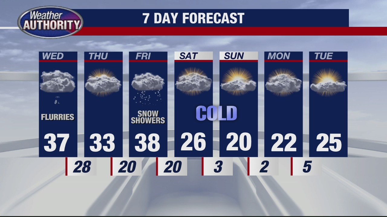
Temperatures both Saturday and Sunday will be a good 10 to 15 degrees below normal under mostly cloudy skies along with a few flurries from time to time. With overnight lows at and below zero, our mornings are going to be especially chilly.
Temperatures both Saturday and Sunday will be a good 10 to 15 degrees below normal under mostly cloudy skies along with a few flurries from time to time. With overnight lows at and below zero, our mornings are going to be especially chilly.


Whirlwind romance follows after tornado crashes Kansas couple's wedding
The events that unfolded on their wedding day nearly 10 years ago, which locals still bring up in town, are a true testament to a life of dedication.
The events that unfolded on their wedding day nearly 10 years ago, which locals still bring up in town, are a true testament to a life of dedication.

Weekend Chill Down
Much colder air expected for the weekend as a cold front moves across the state Friday night. Meteorologist Lori Pinson has your forecast
Much colder air expected for the weekend as a cold front moves across the state Friday night. Meteorologist Lori Pinson has your forecast

Colder Weekend
A shift in wind direction will bring much colder air in time for the weekend. Meteorologist Lori Pinson has your forecast
A shift in wind direction will bring much colder air in time for the weekend. Meteorologist Lori Pinson has your forecast

Frigid Weekend Ahead
Although we're in the upper 30s this afternoon with a rain mix at times, temperatures will nose dive into the teens for highs by both Saturday and Super Bowl Sunday.
Although we're in the upper 30s this afternoon with a rain mix at times, temperatures will nose dive into the teens for highs by both Saturday and Super Bowl Sunday.


A burst of snow Friday morning before temperatures seesaw from warm to freezing this weekend
Up to an inch of snow and rain mix is expected to fall Friday morning before temperatures rise near 40 degrees by the afternoon. Conditions expect to plummet over the weekend.
Up to an inch of snow and rain mix is expected to fall Friday morning before temperatures rise near 40 degrees by the afternoon. Conditions expect to plummet over the weekend.

Metro Detroit weather: Some light snow before temps dip
Rich Luterman has what to expect outside.
Rich Luterman has what to expect outside.

Metro Detroit weather: More cold before a warmup
Rich Luterman has the full forecast.
Rich Luterman has the full forecast.
Friday Morning Snow Showers
Though we are mostly cloudy along with sprinkles and a few flakes today, more light accumulating snow is expected Friday morning. A coating to 1" is possible which could make tomorrow morning's commute a little tricky at times.
Though we are mostly cloudy along with sprinkles and a few flakes today, more light accumulating snow is expected Friday morning. A coating to 1" is possible which could make tomorrow morning's commute a little tricky at times.


Burst of snow and rain expected Thursday night and freezing temperatures over the weekend
Some lingering snow and rain this morning is expected to end by 8 a.m. However, there is a chance for a slushy inch of snow to fall late tonight and early tomorrow morning.
Some lingering snow and rain this morning is expected to end by 8 a.m. However, there is a chance for a slushy inch of snow to fall late tonight and early tomorrow morning.


Isolated snow to turn into rain as temperatures rise throughout Wednesday
A cloudier, warmer day is on the docket for Southeast Michigan this Wednesday. It'll be the first of two potential snowmakers this week, although accumulation looks unlikely as snowfall will transition to rain during both events.
A cloudier, warmer day is on the docket for Southeast Michigan this Wednesday. It'll be the first of two potential snowmakers this week, although accumulation looks unlikely as snowfall will transition to rain during both events.
Warmer for Wednesday with a little snow
Rich Luterman has the forecast.
Rich Luterman has the forecast.

Not too frigid and a little snow
Enjoy the break from the extreme cold while it lasts.
Enjoy the break from the extreme cold while it lasts.


A mix of freezing temperatures and sunshine Tuesday before warmer air moves in
The next precipitation on the way will come Wednesday when temperatures climb above freezing, and that means rain. It'll begin during the afternoon and could linger into Thursday.
The next precipitation on the way will come Wednesday when temperatures climb above freezing, and that means rain. It'll begin during the afternoon and could linger into Thursday.

Warmer temps for the week
Rich Luterman has the forecast.
Rich Luterman has the forecast.


Multiple chances for snow this week with flurries expected Monday
While none of the systems carry the threat of severe weather like last week's, multiple systems are expected drop a mixture of snow and rain throughout the next five days.
While none of the systems carry the threat of severe weather like last week's, multiple systems are expected drop a mixture of snow and rain throughout the next five days.

Chilly Sunday Sunshine
We're mostly sunny this morning becoming partly sunny this afternoon with chilly temperatures in the mid 20s for highs. A few snow flurries are in the forecast on Monday with a light dusting possible.
We're mostly sunny this morning becoming partly sunny this afternoon with chilly temperatures in the mid 20s for highs. A few snow flurries are in the forecast on Monday with a light dusting possible.

Sunday Chill
Another below freezing morning greets you for Sunday. Mainly dry with the wind picking up, making it feel colder. A chance for light snow Monday. Meteorologist Lori Pinson has your forecast
Another below freezing morning greets you for Sunday. Mainly dry with the wind picking up, making it feel colder. A chance for light snow Monday. Meteorologist Lori Pinson has your forecast
Freezing Cold Weekend
Temperatures this weekend will struggle to make it into the low 20s for highs along with a few snow flurries from time to time. Thankfully a little warm up is expected by the middle of the next workweek.
Temperatures this weekend will struggle to make it into the low 20s for highs along with a few snow flurries from time to time. Thankfully a little warm up is expected by the middle of the next workweek.