


Metro Detroit weather: Lingering morning snow to start a cold day
Light snow with minor accumulations this morning could make for a slick commute in Metro Detroit, so take your time.
Light snow with minor accumulations this morning could make for a slick commute in Metro Detroit, so take your time.


Southeast Michigan school closings: Several schools delayed after overnight snow
Some Southeast Michigan schools have delayed classes by two hours to leave time for the roads to be cleared
Some Southeast Michigan schools have delayed classes by two hours to leave time for the roads to be cleared


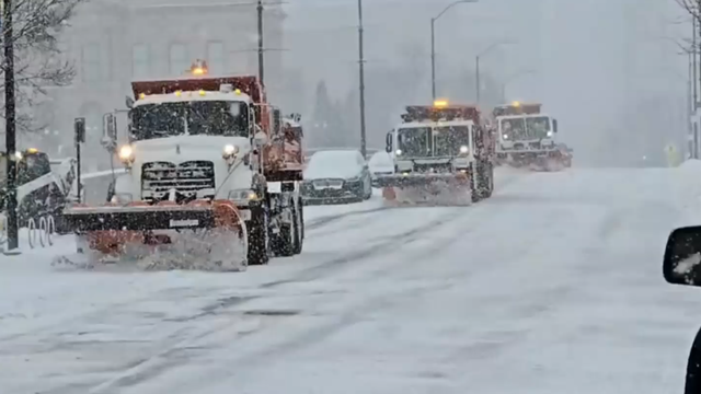
Southeast Michigan road conditions: Slippery commute in some areas after overnight snow
The morning commute is slick in some areas of Metro Detroit, with crashes popping up around Southeast Michigan. Check the live road conditions here:
The morning commute is slick in some areas of Metro Detroit, with crashes popping up around Southeast Michigan. Check the live road conditions here:


Light Snow, Cold Day
Light snow this morning is tapering off leaving minor accumulation. Temperatures only near freezing today with much colder air by Thursday. Meteorologist Lori Pinson has your forecast.
Light snow this morning is tapering off leaving minor accumulation. Temperatures only near freezing today with much colder air by Thursday. Meteorologist Lori Pinson has your forecast.


Metro Detroit overnight snow: Winter weather could affect morning commuters
Metro Detroit residents will see more snow overnight on Monday that could affect commuters Tuesday morning before colder temperatures hit the area later in the week.
Metro Detroit residents will see more snow overnight on Monday that could affect commuters Tuesday morning before colder temperatures hit the area later in the week.


Michigan sees first major winter weather of the 2025 season
Winter is here and that means more snow is coming to Metro Detroit. The good news is that this system isn't going to bring as much snow as people saw Saturday night. Southeast Michigan north of Detroit is expected to see one inch of snow while those south of the city will get two inches.
Winter is here and that means more snow is coming to Metro Detroit. The good news is that this system isn't going to bring as much snow as people saw Saturday night. Southeast Michigan north of Detroit is expected to see one inch of snow while those south of the city will get two inches.


Snow overnight; arctic chill moves in later this week
Another round of light snow is coming our way for late Monday night. There is no warm-up in sight for Metro Detroit. The official start of winter is still three weeks away - yikes.
Another round of light snow is coming our way for late Monday night. There is no warm-up in sight for Metro Detroit. The official start of winter is still three weeks away - yikes.


Detroit apartment tenants forced to vacate units over failed payment to DTE
The owners of The Leland told tenants in a letter sent late November that it had exhausted all possible options and must now close the complex. DTE plans to shut off power to the building on Dec. 3.
The owners of The Leland told tenants in a letter sent late November that it had exhausted all possible options and must now close the complex. DTE plans to shut off power to the building on Dec. 3.


Snow overnight; frigid temps come end of week
Rich Luterman has the forecast.
Rich Luterman has the forecast.


Detroit snow timeline: When to expect Monday night's flakes
More snow is coming to Metro Detroit Monday night. here's what to expect and when it should start in Southeast Michigan.
More snow is coming to Metro Detroit Monday night. here's what to expect and when it should start in Southeast Michigan.


More snow coming to Metro Detroit
Another blast of snow is coming to Metro Detroit as we settle into the winter months. This one could make the drive to work on Tuesday tricky.
Another blast of snow is coming to Metro Detroit as we settle into the winter months. This one could make the drive to work on Tuesday tricky.


Arctic blast ushers in freezing, potentially record cold for 235 million Americans to kick off La Niña winter
Monday is set to be the coldest day of the arctic air outbreak, where temperatures will be subzero across Montana, the Dakotas, Wyoming, Minnesota and Wisconsin.
Monday is set to be the coldest day of the arctic air outbreak, where temperatures will be subzero across Montana, the Dakotas, Wyoming, Minnesota and Wisconsin.


Metro Detroit weather: A cold start to a week that will get even colder
The week starts - and stays - cold in Metro Detroit.
The week starts - and stays - cold in Metro Detroit.


Cold start to a week that will end with a bitter freeze
The week starts cold, and will get even colder. Stephanie Mead has what to expect in Metro Detroit.
The week starts cold, and will get even colder. Stephanie Mead has what to expect in Metro Detroit.

When is the official start of winter? Here's why meteorological winter begins on December 1
Calendars found in homes across the country usually say winter begins on Dec. 21, when in reality the season starts three weeks earlier on Dec. 1.
Calendars found in homes across the country usually say winter begins on Dec. 21, when in reality the season starts three weeks earlier on Dec. 1.


Snow, cold weather in the forecast for this week
A cold weather pattern is expected for the next two weeks. With more chances for some light snow Monday night and again Wednesday night. Rest of Sunday evening / night… Brisk and COLD with some light snow showers… low 18 Monday: Increasing clouds…. COLD…. snow arrives late Monday evening and lasts through Monday night…. 1-2 inches. High ner 30 Tuesday: Mostly cloudy…. some morning flurries…. COLD…. high 32 Wednesday: Mostly cloudy… some light snow late Wed. night…. high 32 Thursday: Sun and clouds…. VERY COLD….. high 25 Friday: Mostly cloudy…. VERY COLD….. high 26 Saturday: Mostly cloudy…. still COLD…. high near 30
A cold weather pattern is expected for the next two weeks. With more chances for some light snow Monday night and again Wednesday night. Rest of Sunday evening / night… Brisk and COLD with some light snow showers… low 18 Monday: Increasing clouds…. COLD…. snow arrives late Monday evening and lasts through Monday night…. 1-2 inches. High ner 30 Tuesday: Mostly cloudy…. some morning flurries…. COLD…. high 32 Wednesday: Mostly cloudy… some light snow late Wed. night…. high 32 Thursday: Sun and clouds…. VERY COLD….. high 25 Friday: Mostly cloudy…. VERY COLD….. high 26 Saturday: Mostly cloudy…. still COLD…. high near 30


Lori's Stories: Squid Game the Challenge pt 2
What are the games like on Squid Game the Challenge? Player #263 answers that and more in this continuation of Lori's Stories
What are the games like on Squid Game the Challenge? Player #263 answers that and more in this continuation of Lori's Stories


Lori's Stories: Squid Game the Challenge
On today's Lori's Stories, Lori Pinson talks with Livonia native Kelly Bernadyn, also known as player #263 from the reality show Squid Game: the Challenge. We get an exclusive look at her audition tape and the process of contestant selection.
On today's Lori's Stories, Lori Pinson talks with Livonia native Kelly Bernadyn, also known as player #263 from the reality show Squid Game: the Challenge. We get an exclusive look at her audition tape and the process of contestant selection.


Cold, Windy Sunday
Snow tapering off this morning with most areas receiving 4" of accumulation. Cold, windy conditions with wind chills in the teens and single digits. A cold week ahead. Meteorologist Lori Pinson has your forecast.
Snow tapering off this morning with most areas receiving 4" of accumulation. Cold, windy conditions with wind chills in the teens and single digits. A cold week ahead. Meteorologist Lori Pinson has your forecast.


Heavy snow fall expected through 2 a.m. lighter accumulation into late Sunday morning
Alan Longstreet says that the heaviest of the snow will be done around 2 a.m., with light flurries continuing through lunchtime on Sunday.
Alan Longstreet says that the heaviest of the snow will be done around 2 a.m., with light flurries continuing through lunchtime on Sunday.